Log in
All resources
Create a design
27,441 Free Images of Maps
koninklijke bibliotheek
maps by jakob van der schley
engraving on paper
jakob van der schley
joan blaeu
david rumsey historical map collection
latin-language maps
atlas map
maps of the west-indische compagnie
1747 maps of africa
coats of arms of cities in oise
pierre de la ramée
old maps of guernsey
old maps of jersey
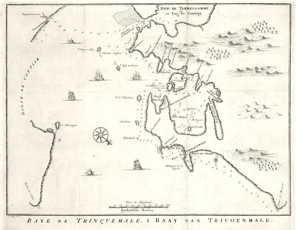
maps of the dutch east india company - sri lanka
1753 maps
eran laor cartographic collection
matthew paris
r. hausermann, carte de la terre sainte, 1914
eran laor cartographic collection
maps of tangier by braun & hogenberg
maps of asilah by braun & hogenberg
everett d. graff collection of western americana
stephen f. austin
maps of landkreis elbe-elster
old maps of saxony
old maps of the sea of marmara
catalan atlas
maps of the dutch east india company - indonesia
18th-century maps of new guinea
johannes nessel
1658 maps
historisk atlas (stockholm, norstedt & söner, 1880)
maps showing 843
ptolemy's 9th asian map
bologna ptolemy
old maps of the new kingdom of granada
1680
media from the national library of finland
classicism
guide joanne espagne et portugal-1906
french-language maps
nouvelle géographie universelle, vol. xii
charles eugène perron
maps made in the 17th century
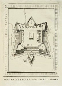
forts in the netherlands
eran laor cartographic collection
latin-language maps
maps by willem and johannes blaeu
maps of erkelenz
18th-century maps of zeeland
maps by isaak tirion
maps from the earth and its inhabitants, vol. xii
africa in the 1890s
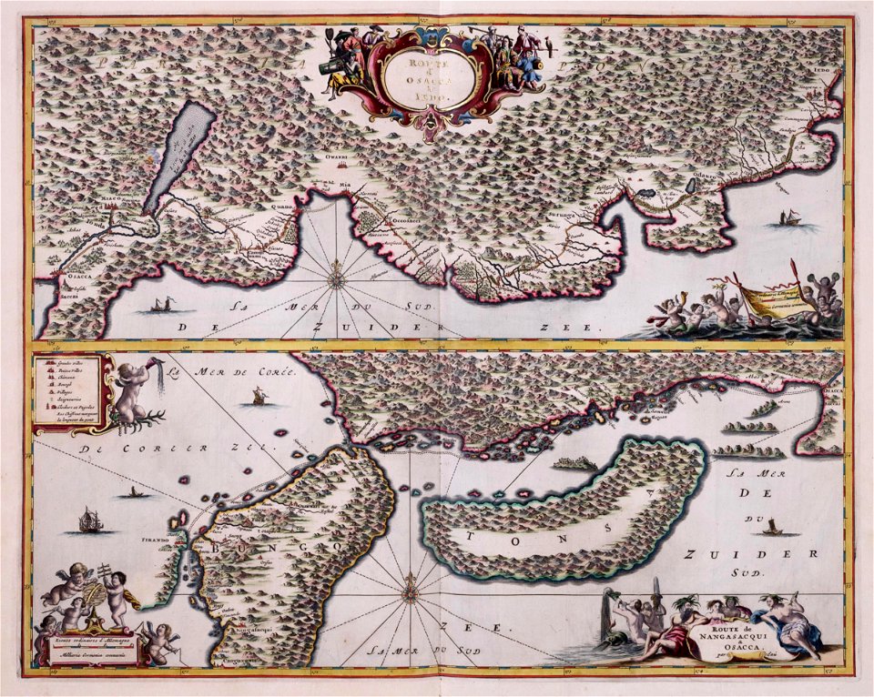
maps of the dutch east india company - japan
1669 maps
maps of the west-indische compagnie
1662
maps of the west-indische compagnie
1747 maps of africa
maps of the west-indische compagnie
1747 maps of africa
maps of the west-indische compagnie
1747 maps of africa
maps of the west-indische compagnie
1747 maps of africa
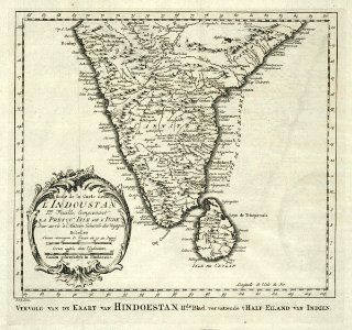
maps of the dutch east india company - india
1755 maps
maps of the west-indische compagnie
1747 maps of africa
maps of the dutch east india company - indonesia
claudius anthony van luepken
atlas des anciens plans de paris by imprimerie nationale, 1900 from the david rumsey historical map collection
maps of paris from the david rumsey historical map collection
atlas des anciens plans de paris by imprimerie nationale, 1900 from the david rumsey historical map collection
maps of paris from the david rumsey historical map collection
description de l'universe
1680s maps of england
daniel de la feuille
1747 maps
1747 maps of new hampshire
english-language maps
1891 maps of austria-hungary
maps from gallica
maps by john cary
1799 maps
atlas des anciens plans de paris by imprimerie nationale, 1900 from the david rumsey historical map collection
maps of paris from the david rumsey historical map collection
maps of paris from the david rumsey historical map collection
map of paris by françois quesnel
maps of paris from the david rumsey historical map collection
map of paris by françois quesnel
maps of paris from the david rumsey historical map collection
map of paris by françois quesnel
old maps of the arctic
maps by emanuel bowen
norman heathcote
maps of st kilda
guide joanne normandie-1912
1912 maps of france
maps from the earth and its inhabitants, vol. vi
population density maps of russia
maps from the earth and its inhabitants, vol. vii
population density maps of china
maps from the earth and its inhabitants, vol. xviii
maps of the conquest of peru
maps from the earth and its inhabitants, vol. vi
ferdinand von richthofen
maps from the earth and its inhabitants, vol. xvi
guillaume le testu
postcards of alaska
map postcards
media contributed by university of illinois urbana-champaign university library
negroland
maps in the stadsarchief amsterdam
17th-century maps of amsterdam
foire saint-germain on old maps
baroque
engravings of topographia bohemiae moraviae et silesiae
baroque
media from the national library of finland
classicism
africa and its inhabitants, vol. ii
charles eugène perron
french-language maps
1742 maps
fra mauro map details
fra mauro map
maps from the earth and its inhabitants, vol. vi
1891 maps of georgia
compass roses on maps
compasses in spain
maps in the library of congress
old maps of new york (state)
eran laor cartographic collection
william henry toms
ptolemy's 1st european map
bologna ptolemy
eran laor cartographic collection
thesaurus philopoliticus
maps of the great western railway
charles frederick cheffins
atlas maior, vol 11 (asia) - joan blaeu, 1667 - bl 114.h(star).11
1667 maps
17th-century maps of bordeaux
17th-century maps of dordogne
1720s maps showing history
1727 maps of africa
old maps of charente-maritime
maps by nicolas sanson
atlas maior, vol 4 (netherlands) - joan blaeu, 1667 - bl 114.h(star).4
1667 maps
1660s maps of spain
1667 maps
17th-century maps of xaintonge
old maps of charente-maritime
victory expedition
northwest passage
maps by willem and johannes blaeu
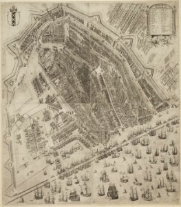
old maps of amsterdam
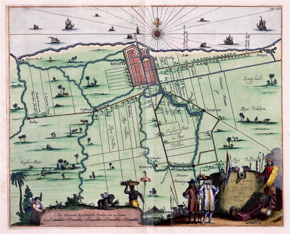
maps of the dutch east india company - indonesia
17th-century maps of batavia
old maps of lindisfarne
joan blaeu
amsterdam in the 1590s
pieter bast
media from the national library of finland
classicism
kasteel batestein (vianen)
maps of vianen
maps of territories in the burgundian circle
1645 maps of belgium
cartes de franz schrader
1894 maps of france
arabian expedition (1761-1767)
historical images of yemen
ancona (galleria delle carte geografiche)
ancona in art
maps in the british museum
1780s maps of france
maps of seto inland sea
osaka castle in art
old maps of north brabant
jacobus harrewijn
gemeente atlas van nederland - north holland
19th-century maps of amsterdam
gemeente atlas van nederland - north holland
amsterdam in the 1860s
maps of the history of sweden
1386 in sweden
former new york life insurance company building
sanborn maps of manhattan published in 1905
maps by emanuel bowen
1750s maps of germany
maps from the mechanical curator collection
19th-century maps of the nile river
siege of geertruidenberg 1593
maps of geertruidenberg
1470s maps of the world
latin-language maps
18th-century maps of puerto rico
1785 maps
french-language maps of asia
1750s maps of asia
maps by gerard valck
atlas beudeker
maps of paris from the barry lawrence ruderman antique maps inc.
key sheet of the turgot map of paris
gloucester, massachusetts, in the 19th century
1851 maps of massachusetts
2501 - 2600 of 27,441
Next page
/ 275