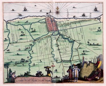
Map of batavia and environs taken from the atlas van der hagen, koninklijk bibliotheek, the hague, part 4. Black & whiteversion of the same map: koninklijke bibliotheek, inv. Nr. 388 a 9 deel ii, na p. 196. Cf. Westfries museum, inv. Nr. 15252, tropenmuseum / kit, inv. Nr. 5681-3 and koninklijke bibliotheek, inv. Nr. 2102a 7, p. 118. Date: 1682. Dimensions: height: 36 cm (14.1 in); width: 28 cm (11 in). Medium: copperplate printing on paper. Collection: Koninklijke Bibliotheek. AMH-5641-KB Map of Batavia and environs
Loading...