Map of the minor Antilles, Joan Blaeu, 1662

Map of the minor Antilles, Joan Blaeu, 1662

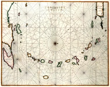
Map of the minor antilles. Canibales insulae. This map of the antilles was published in 1662 in the 11th part of joan blaeu's (1598-1673) 'atlas maior'. The indigenous population of the caribbean region called themselves 'canibales'. They ate human flesh, which was considered so unusual that the name 'canibales' came to be used as the name for consumers of human flesh in almost every language. Date: 1662. Dimensions: height: 54 cm (21.2 in); width: 42 cm (16.5 in). Medium: coloured engraving on paper. Collection: Koninklijke Bibliotheek. AMH-7753-KB Map of the minor Antilles
Edit image
Published by:
Creazilla
Author: Joan BlaeuSource: commons.wikimedia.org

Loading...

0 downloads
Loading...
maps of the west-indische compagnie166217th-century maps of the caribbeanmaps by willem and johannes blaeucoloured engraving on paperkoninklijke bibliotheekjoan blaeu

MORE LIKE THIS

Creazilla logo
Over 10 million free graphic resources for content creators and designers.
© 2018 - 2025 Creazilla
Our resourcesAll imagesPhotosDigital illustrationsClipartIconsPNG ImagesEmojisSilhouettesTraditional Art3D ModelsVectorsFontsColor namesColor palettesGradientsAudioAnimationVideosTemplates
InformationAbout CreazillaTerms of useTech teamPrivacy policyLicence Information
FeedbackContact Us