Log in
All resources
Create a design
85 Free Artworks of Gemeente Atlas Van Nederland North Holland
1860s maps of north holland
media from regionaal archief alkmaar
jacob kuyper
old maps of haarlem
maps of texel
old maps of alkmaar
19th-century maps of amsterdam
maps of barsingerhorn
old maps of hoorn, north holland
oudkarspel
gemeente atlas van nederland - north holland
maps of haarlemmerliede en spaarnwoude
noordzeekanaal
maps of velsen
gemeente atlas van nederland - north holland
19th-century maps of amsterdam
gemeente atlas van nederland - north holland
1860s maps of north holland
gemeente atlas van nederland - north holland
sloten (amsterdam)
gemeente atlas van nederland - north holland
maps of kwadijk
media from regionaal archief alkmaar
maps of barsingerhorn
media from regionaal archief alkmaar
maps of texel
gemeente atlas van nederland - north holland
maps of beets, north holland
gemeente atlas van nederland - north holland
maps of jisp
gemeente atlas van nederland - north holland
old maps of hoorn, north holland
media from regionaal archief alkmaar
oudkarspel
gemeente atlas van nederland - north holland
maps of hoogkarspel
gemeente atlas van nederland - north holland
maps of ursem
gemeente atlas van nederland - north holland
maps of wieringerwaard
gemeente atlas van nederland - north holland
maps of avenhorn
gemeente atlas van nederland - north holland
maps of hensbroek
gemeente atlas van nederland - north holland
maps of wormerveer
gemeente atlas van nederland - north holland
maps of westzaan
gemeente atlas van nederland - north holland
maps of katwoude
gemeente atlas van nederland - north holland
maps of wognum
gemeente atlas van nederland - north holland
maps of middelie
gemeente atlas van nederland - north holland
maps of wijdewormer
gemeente atlas van nederland - north holland
maps of spanbroek
gemeente atlas van nederland - north holland
maps of landsmeer
gemeente atlas van nederland - north holland
maps of twisk
gemeente atlas van nederland - north holland
maps of ilpendam
gemeente atlas van nederland - north holland
maps of schellinkhout
gemeente atlas van nederland - north holland
maps of hoogwoud
gemeente atlas van nederland - north holland
maps of opperdoes
gemeente atlas van nederland - north holland
maps of opmeer
gemeente atlas van nederland - north holland
maps of urk
gemeente atlas van nederland - north holland
maps of obdam
gemeente atlas van nederland - north holland
maps of sijbekarspel
gemeente atlas van nederland - north holland
maps of oosthuizen
gemeente atlas van nederland - north holland
old maps of hoorn, north holland
gemeente atlas van nederland - north holland
maps of venhuizen
media from regionaal archief alkmaar
winkel, north holland
gemeente atlas van nederland - north holland
old maps of haarlem
gemeente atlas van nederland - north holland
maps of broek in waterland
gemeente atlas van nederland - north holland
maps of bussum
gemeente atlas van nederland - north holland
maps of bergen, north holland
old maps of koedijk
old maps of alkmaar
gemeente atlas van nederland - north holland
blokker
media from regionaal archief alkmaar
maps of wieringen
gemeente atlas van nederland - north holland
maps of schoorl
gemeente atlas van nederland - north holland
maps of stede broec
gemeente atlas van nederland - north holland
old maps of castricum
media from regionaal archief alkmaar
maps of wieringerwaard
gemeente atlas van nederland - north holland
maps of heiloo
gemeente atlas van nederland - north holland
old maps of castricum
media from regionaal archief alkmaar
old maps of schagen
gemeente atlas van nederland - north holland
maps of diemen
gemeente atlas van nederland - north holland
amsterdam in the 1860s
media from regionaal archief alkmaar
oudkarspel
gemeente atlas van nederland - north holland
19th-century maps of den helder
gemeente atlas van nederland - north holland
bennebroek
gemeente atlas van nederland - north holland
old maps of heemstede, north holland
gemeente atlas van nederland - north holland
maps of schermer
gemeente atlas van nederland - north holland
maps of texel
gemeente atlas van nederland - north holland
maps of bloemendaal
gemeente atlas van nederland - north holland
maps of uithoorn
gemeente atlas van nederland - north holland
maps of zandvoort
media from regionaal archief alkmaar
sint pancras
gemeente atlas van nederland - north holland
old maps of haarlem
media from regionaal archief alkmaar
maps of barsingerhorn
gemeente atlas van nederland - north holland
old maps of alkmaar
media from regionaal archief alkmaar
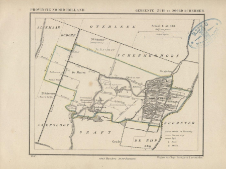
zuidschermer
media from regionaal archief alkmaar
old maps of koedijk
media from regionaal archief alkmaar
limmen
media from regionaal archief alkmaar
schoorl
media from regionaal archief alkmaar
oterleek
gemeente atlas van nederland - north holland
old maps of amsterdam
media from regionaal archief alkmaar
maps of heiloo
media from regionaal archief alkmaar
scharwoude
media from regionaal archief alkmaar
sint pancras
media from regionaal archief alkmaar
egmond-binnen
gemeente atlas van nederland - north holland
old maps of haarlem
gemeente atlas van nederland - north holland
egmond-binnen
gemeente atlas van nederland - north holland
old maps of beverwijk
media from regionaal archief alkmaar
broek op langedijk
gemeente atlas van nederland - north holland
ransdorp
old maps of schagen
maps of zijpe
gemeente atlas van nederland - north holland
maps of egmond aan zee
gemeente atlas van nederland - north holland
maps of texel
1 - 85 of 85
/ 1