Log in
All resources
Create a design
82 Free Artworks of Old Maps Showing History
english-language maps showing history
the comprehensive history of england (1876)
1870s maps showing history
bibliothèque nationale de france
dutch-language maps
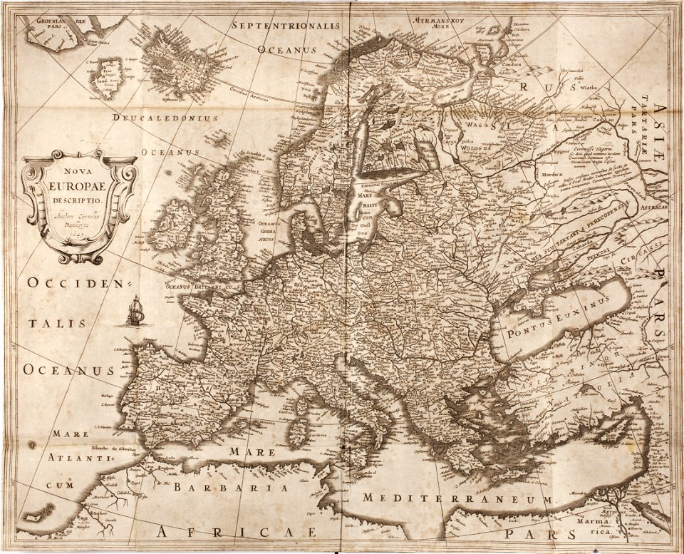
latin-language maps
old maps of the white sea
maps of the barents sea
whales on maps
baptista van doetecum
third voyage of willem barentsz
history of dutch sea fisheries
the voyage of the vega round asia and europe
third voyage of willem barentsz
european interpretation of islamic art
old maps of baghdad
itinerario (jan huygen van linschoten)
latin-language maps
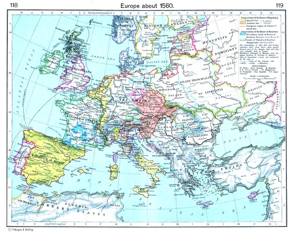
old maps showing history of europe
old maps of the holy roman empire
prints from dankaerts historis at the peace palace library
cornelis danckerts (i)
old maps of the carolingian empire
old maps of europe
maps showing 18th-century history
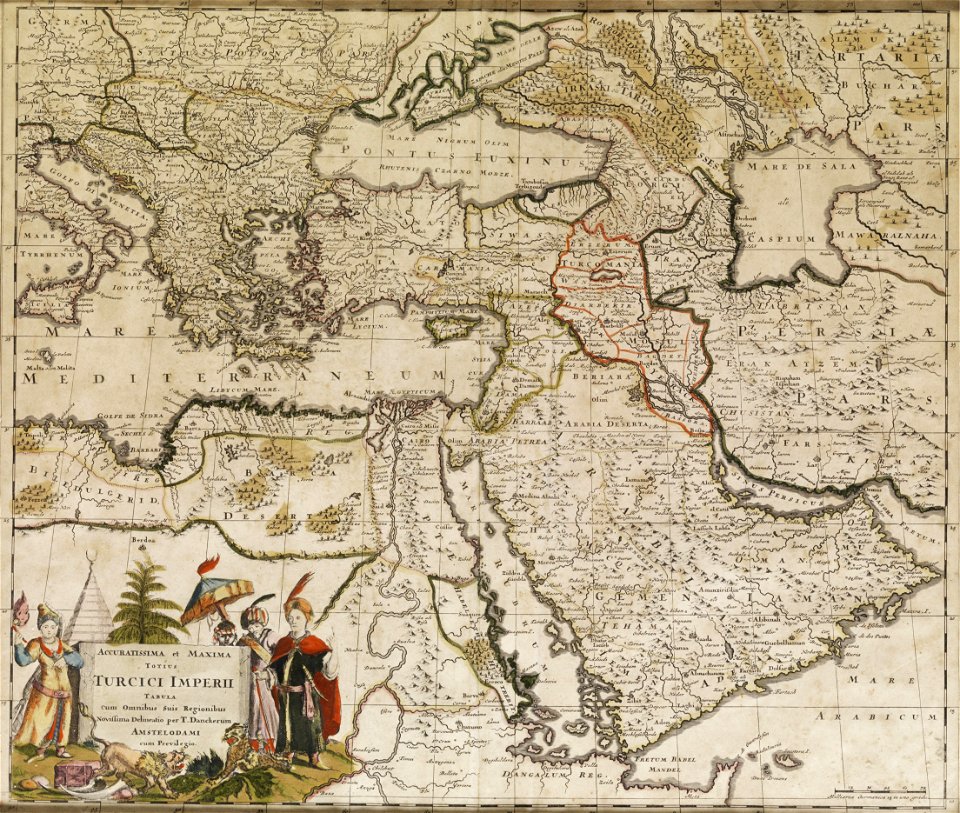
old maps of the ottoman empire
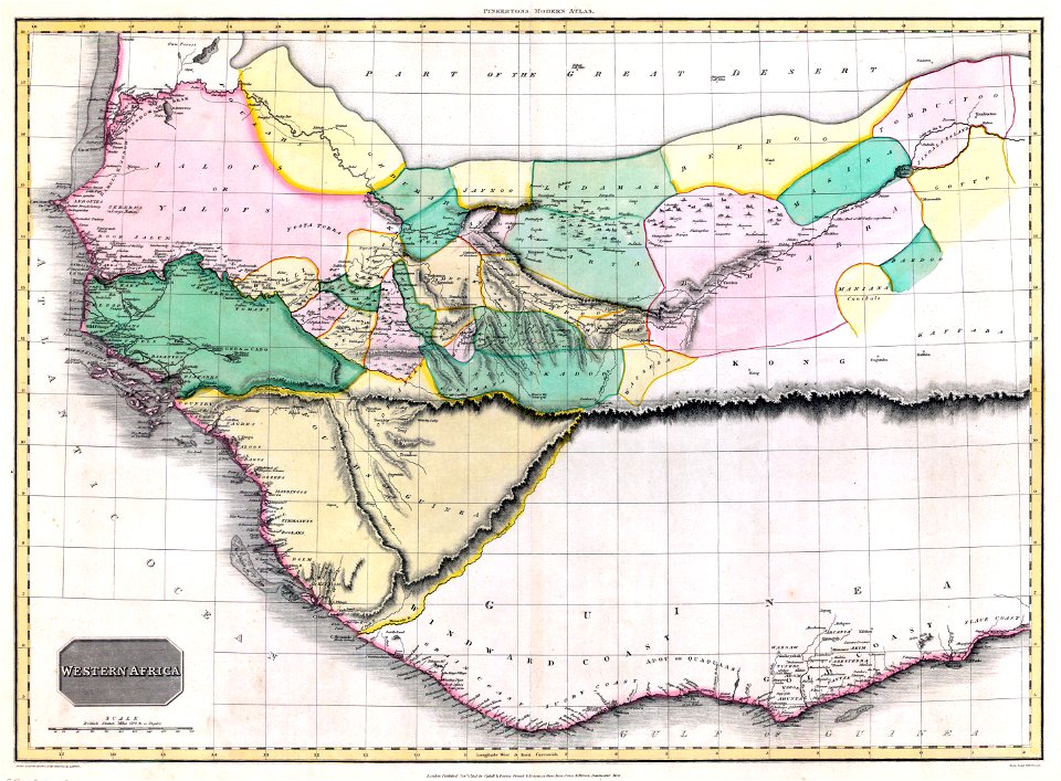
old maps of guinea-bissau
old maps of liberia
18th-century maps of puerto rico
18th-century maps of cuba
german-language maps showing history of europe
maps by brockhaus
maps showing 19th-century history
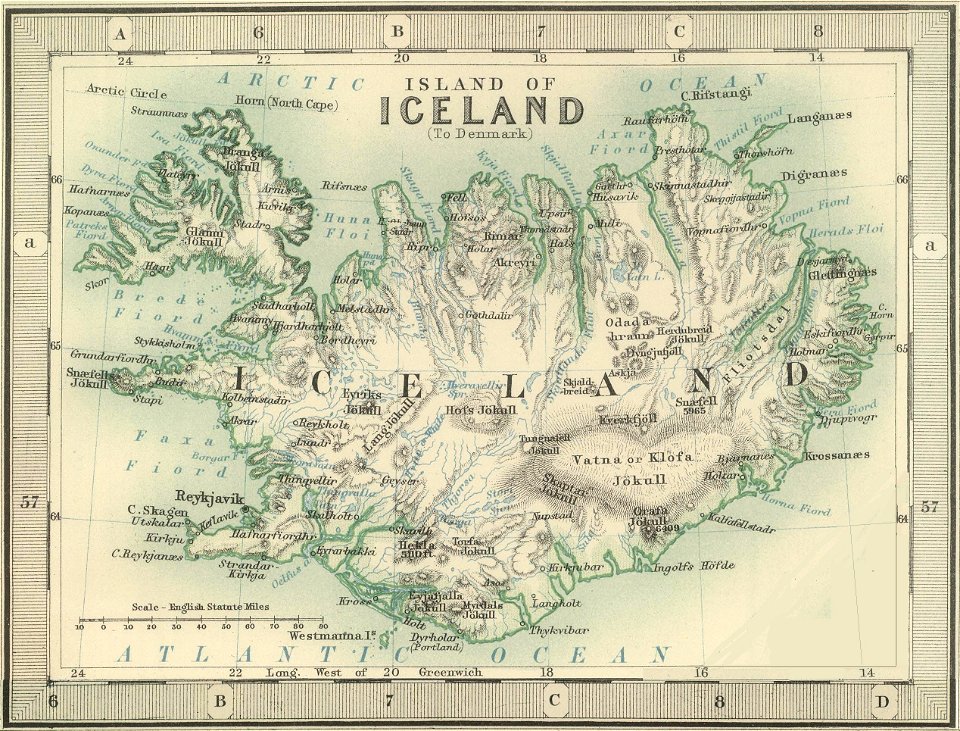
old maps of iceland
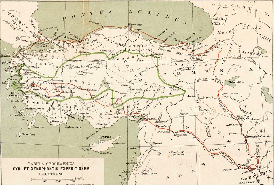
ten thousand campaign
old maps of turkey
david rumsey historical map collection
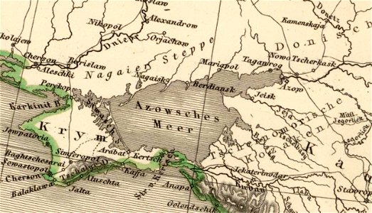
old maps of the sea of azov
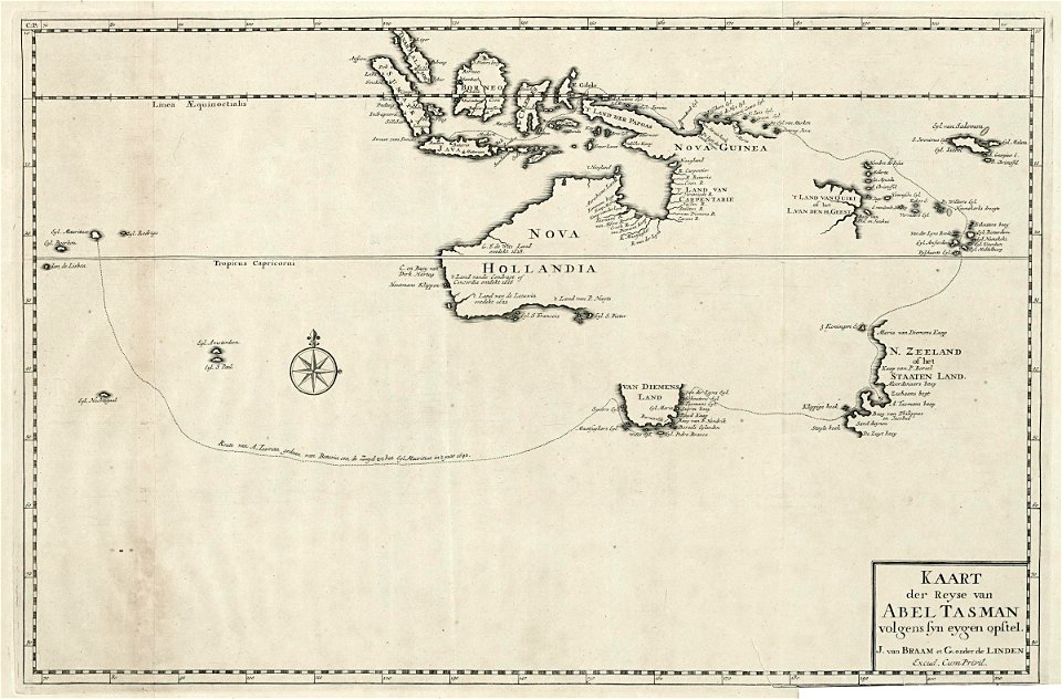
abel tasman
1724 maps
maps from allgemeiner historischer handatlas
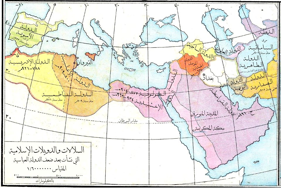
arabic-language maps
johann baptist homann
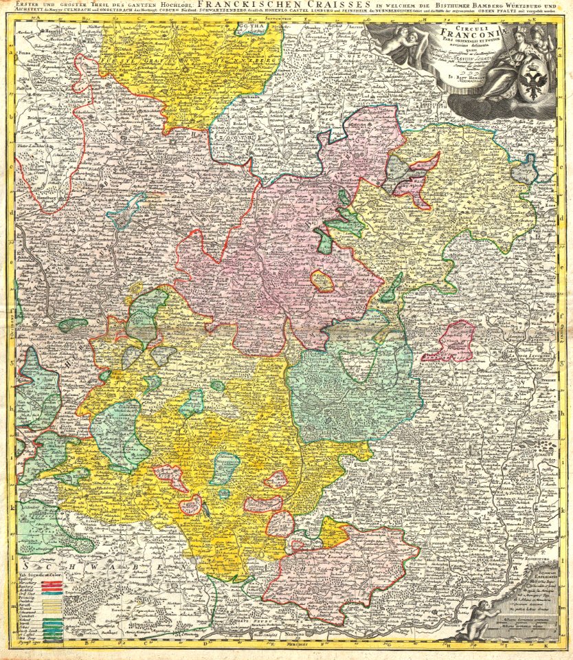
maps of franconia
old maps showing history of europe
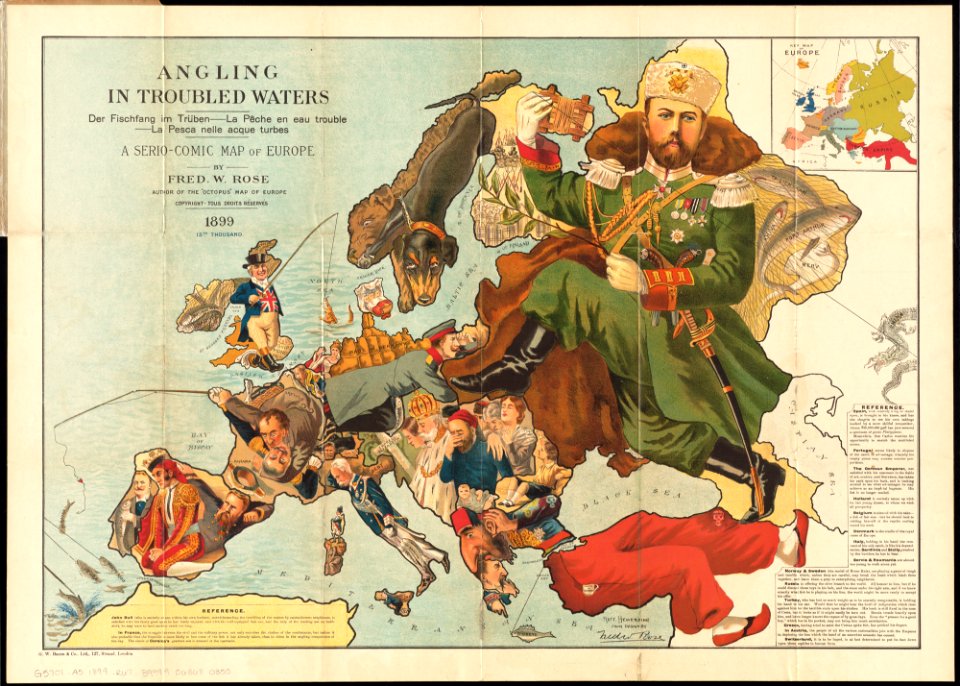
1899 maps
dutch 18th-century prints in the rijksmuseum amsterdam
hendrik de leth
itinerario (jan huygen van linschoten)
latin-language maps
old administrative maps of the ottoman empire
1909 maps of asia
itinerario (jan huygen van linschoten)
latin-language maps
john rocque's 1746 map of london
details of old maps of london
maps of nieuwkoop
aarlanderveen
old maps of the kingdom of france (987-1792)
19th-century maps of the british isles
engravings of buildings
maps by pieter mortier
old maps of rhineland-palatinate
old maps of alsace
maps showing 19th-century history
19th-century maps of south asia
old maps of são paulo (city)
maps of são paulo (city)
john rocque's 1746 map of london
history of london
old maps of krefeld
1645 in krefeld
old maps of marche
1624 maps of italy
old maps showing history
1820s maps of europe
historisk atlas (stockholm, norstedt & söner, 1880)
old maps of the polish-lithuanian commonwealth
library of the university of vienna
map of vienna by jacob hoefnagel
eran laor cartographic collection
maps by tomas lopez
maps by guillaume delisle showing history
old maps of alexander the great's empire
maps by nicolaes visscher i
old maps of assyria
the comprehensive history of england (1876)
english-language maps showing history
the comprehensive history of england (1876)
english-language maps showing history
the comprehensive history of england (1876)
english-language maps showing history
the comprehensive history of england (1876)
english-language maps showing history
the comprehensive history of england (1876)
english-language maps showing history
the comprehensive history of england (1876)
english-language maps showing history
maps of ancient israel by philippe de la rué
map of modern syria by philippe de la rué
maps by daniel lizars
1830s maps of belize
antoine-françois tardieu
maps from gallica
the comprehensive history of england (1876)
danube in 1704
1830s maps of switzerland
1834 maps of europe
johann david schleuen
old maps of prussia
1720s maps showing history
1727 maps of africa
the comprehensive history of england (1876)
english-language maps showing history
the comprehensive history of england (1876)
english-language maps showing history
the comprehensive history of england (1876)
english-language maps showing history
the comprehensive history of england (1876)
english-language maps showing history
the comprehensive history of england (1876)
english-language maps showing history
the comprehensive history of england (1876)
english-language maps showing history
1850s maps of the americas
maps by john tallis
nicolas desmarest
ambroise tardieu
old maps showing history of europe
description de l'universe
old maps showing the history of the former colonies of france
cartes de franz schrader
maps of the history of morocco
empire of morocco
map of ancient assyria by philippe de la rué
old maps of mesopotamia
redeeming the republic (1890)
1890s maps showing history
guillaume-nicolas delahaye
jacques martin
1840s maps showing history
maps by thomas starling
maps in the library of congress
1770s maps showing history
maps by jakob van der schley
old maps of southeast asia
old maps of st. augustine, florida
john white (colonist and artist)
redeeming the republic (1890)
1890s maps showing history
atlas minor gerardi mercatoris (1609)
maps of asia by mercator-hondius
colonial history of the united states
old maps of new york (state)
maps of ancient israel by philippe de la rué
old maps of ancient israel
maps of the greek colonies
old maps of ancient greece
civitates orbis terrarum. urbium praecipuarum totius mundi. liber quartus
old maps of ancient rome (city)
1805 maps of the united states
maps by john cary
maps in the rijksmuseum amsterdam
18th-century maps showing history
nicolas sanson. “mappe-monde, ou carte generale du monde.”
1667 map of madagascar by guillaume sanson
nicolas sanson. “mappe-monde, ou carte generale du monde.”
map of the bosphorus strait by guillaume sanson (1665)
john thomas smith (1766-1833)
clarendon house
old maps of cities in indonesia
tuban
etchings in the rijksmuseum amsterdam
history of rotterdam
1 - 82 of 82
/ 1