Log in
All resources
Create a design
26,489 Free Artworks of Map
maps by willem and johannes blaeu
gemeente atlas van nederland - south holland
1860s maps of south holland
bibliothèque nationale de france
maps in the library of congress
joan blaeu
paper
map - museu antônio parreiras
antônio parreiras
maps by girolamo porro
gemeente atlas van nederland - south holland
19th-century maps of rotterdam
maps by willem and johannes blaeu
17th-century maps of scandinavia
university of amsterdam
map of amsterdam, 1544
nypl collection of atlases, gazetteers, guidebooks and other books
nypl lionel pincus and princess firyal map division
1710s maps of eastern europe
muscovy
18th-century maps of antwerp
anna beeck
former theatres in boston
boston in the 1910s
pacific ocean in art
ships on maps
old maps of montana
julius bien
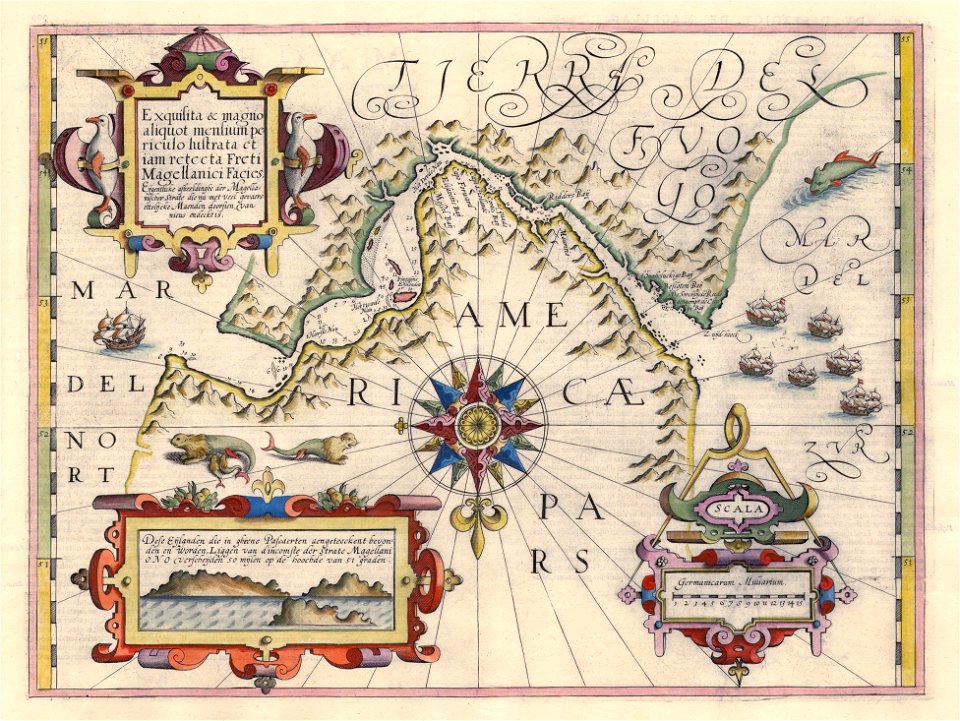
maps of the magellan straits by lambert cornelis
old maps of the dutch east india company
cartes de franz schrader
gavarnie
1794 rocque wall map of ireland
graphical scales
old maps of freiburg im breisgau
emery walker
guide joanne espagne et portugal-1915
1915 maps
maps by gerard de jode
1593 maps of africa
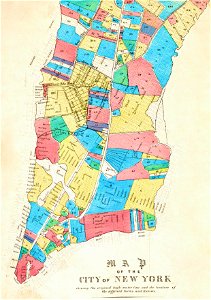
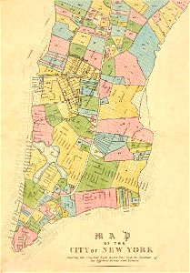
manual of the corporation of the city of new york (1853)
maps from valentine's manual
manual of the corporation of the city of new york (1852)
george hayward
victor levasseur - maps of france
baroque
18th-century maps of the indian ocean
bodleian maps collection
map of bruges by marcus gheeraerts (i)
drawings in the groeningemuseum
maps in the library of congress
1852 maps of massachusetts
maps by willem and johannes blaeu
atlas van loon
maps in the library of congress
1830s maps of china
maps of paris from bibliothèque nationale de france
ludovic baschet
maps by tomas lopez
1785 maps of africa
19th-century maps of the malay archipelago
the cruise of the marchesa (1889)
a & c black general atlas of the world
1850s maps of the world
old maps of ghent by jacques horenbault
sint-amandsberg
maps of ghent by braun & hogenberg
old maps of china in harvard map collection
1749 maps of asia
maps of hamburg-altstadt
1588 maps of hamburg
maps by thomas kitchin
1781 maps of europe
maps in the library of congress
1866 maps of pennsylvania
maps in the library of congress
1758 maps of cuba
1760s maps of the iberian peninsula
1762 maps of spain
landais & oberthur
maps from gallica
mappe-monde by guillaume delisle (18th century)
french-language maps of the world
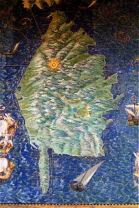
corsica (galleria delle carte geografiche)
corsican guard
cornelis de jode
1579 maps
nouvelle géographie universelle, vol. xii
1890s maps of africa
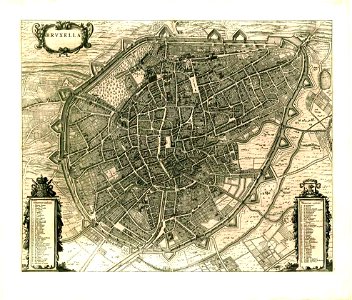
maps of brussels city walls
old maps of brussels
maps by willem and johannes blaeu
old maps of stavoren
maps by girolamo porro
1600 maps of asia
maps by jan janssonius
1640s maps of africa
curt teich postcard archives
map postcards
maps by willem and johannes blaeu
old maps of axel
maps by willem and johannes blaeu
old maps of hesse
maps by girolamo porro
1600 maps of asia
maps by girolamo porro
1598 maps of russia
maps by willem and johannes blaeu
1653 maps
maps by willem and johannes blaeu
17th-century maps of japan
eran laor cartographic collection
willem blaeu
atlas des anciens plans de paris by imprimerie nationale, 1880 from the musée carnavalet
maps of paris from paris musées
apsley cherry-garrard
edward wilson
drawings in the museu antônio parreiras
india ink and watercolor
maps of london by braun & hogenberg
maps of old london (book)
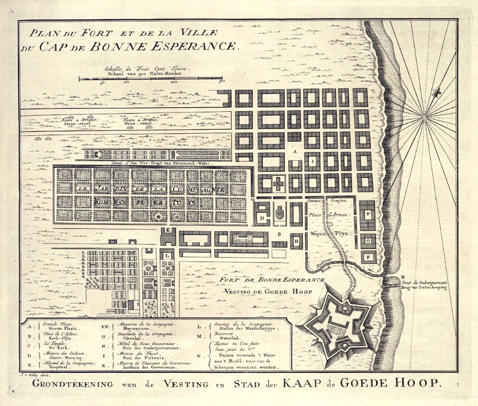
maps of the dutch east india company - south africa
1747 maps of africa
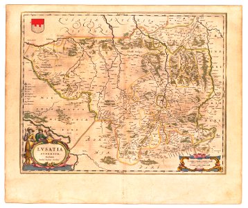
old maps of upper lusatia
coats of arms on maps
maps of the duchy of courland and semigallia
maps of the great northern war
prato in the 20th century
maps of prato
16th-century maps of the philippines
maps by pieter van der keere
cornell's primary geography (1860)
1867 maps of africa
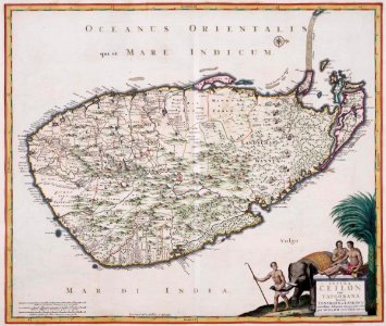
maps of the dutch east india company - sri lanka
1680s
maps of the west-indische compagnie
1665
map collection of leibniz-institut für länderkunde
maps of spain by tomas lopez
map collection of leibniz-institut für länderkunde
maps of spain by tomas lopez
collections of the national library of israel
1725 maps
maps in the british museum
maps by john speed
1610s maps of the holy roman empire
jacques surhon
maps by willem and johannes blaeu
laurens reael
vrbivm praecipvarvm totivs mvndi liber tertivs (1616)
maps of fortress of charlemont by braun & hogenberg
maps of chimay by braun & hogenberg
maps of chimay city walls
miniature speed atlas (1627) pieter van den keere
old county maps of herefordshire
göteborg harbour
nya varvet
maps in the staats- und universitätsbibliothek hamburg
1588 maps of hamburg
drawings in the museu antônio parreiras
paper
drawings in the museu antônio parreiras
wood
1572 maps of africa
1570s maps of egypt
brazilian paintings in the museu antônio parreiras
wood
plans of central cemetery in sanok
maps of sanok
russian geographical society
stamps of russia, 2020
maps from the earth and its inhabitants, vol. xi
africa in the 1890s
gemeente atlas van nederland - south holland
1860s maps of south holland
gemeente atlas van nederland - south holland
maps of zoeterwoude
maps by willem and johannes blaeu
old maps of coevorden
gemeente atlas van nederland - south holland
1860s maps of south holland
17th-century maps of the americas
island of california
gemeente atlas van nederland - south holland
1860s maps of south holland
gemeente atlas van nederland - south holland
1860s maps of south holland
maps from the earth and its inhabitants, vol. xiii
africa in the 1890s
curt teich postcard archives
postcards of illinois
gemeente atlas van nederland - south holland
1860s maps of south holland
gemeente atlas van nederland - south holland
1860s maps of south holland
maps made in the 17th century
johannes van keulen
maps of antwerp city walls
old maps of antwerp
chicago and the midwest, newberry library
illinois & michigan canal
maps showing 19th-century history
isaiah thomas (publisher)
eran laor cartographic collection
cornelis de bruyn
clifton (bristol ward)
old maps of clifton
atlas maior, vol 3 (germany) - joan blaeu, 1667 - bl 114.h(star).3
johannes gigas
4001 - 4100 of 26,489
Next page
/ 265