Map of Ceylon, Nicolaes Visscher, between 1681 and 1690

Map of Ceylon, Nicolaes Visscher, between 1681 and 1690

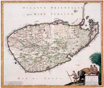
Map of ceylon excerpted from the atlas van der hagen, koninklijk bibliotheek, the hague, part 4. The island of ceylon was captured by the dutch from the portuguese between 1655 and 1658. The conquest was significant as it ensured the dutch east india company gained a monopoly on the trade in cinnamon. Date: between 1681 and 1690. Dimensions: height: 60 cm (23.6 in); width: 50 cm (19.6 in). Medium: copperplate printing on paper. Collection: Koninklijke Bibliotheek. AMH-5640-KB Map of Ceylon
Edit image
Published by:
Creazilla
Author: Nicolaas Visscher II (publisher)Source: commons.wikimedia.org

Loading...

0 downloads
Loading...
maps of the dutch east india company - sri lanka1680smaps of ceylon by nicolaes visschercopperplate printing on paperkoninklijke bibliotheeknicolaes visscher

MORE LIKE THIS

Creazilla logo
Over 10 million free graphic resources for content creators and designers.
© 2018 - 2025 Creazilla
Our resourcesAll imagesPhotosDigital illustrationsClipartIconsPNG ImagesEmojisSilhouettesTraditional Art3D ModelsVectorsFontsColor namesColor palettesGradientsAudioAnimationVideosTemplates
InformationAbout CreazillaTerms of useTech teamPrivacy policyLicence Information
FeedbackContact Us