Log in
All resources
Create a design
205 Free Artworks of Graphical Scales
map collection of leibniz-institut für länderkunde
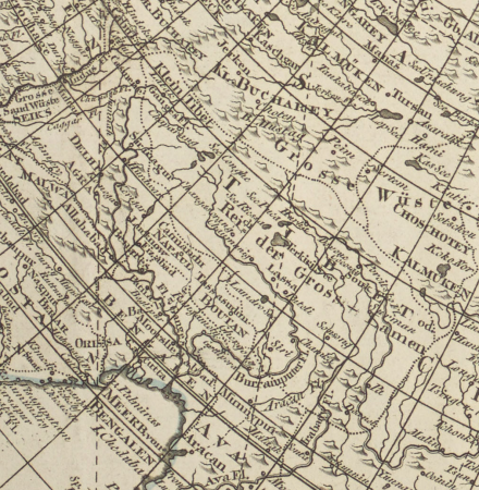
grenzkarte der preussischen, russischen und oestreichischen monarchien (1796)
tranquillo mollo
bibliothèque nationale de france
kieler hafen als künftiger kriegshafen
prints in musée carnavalet
les plus belles maisons de paris (krafft & ransonnette)
1800s maps of the world
old maps of kiel
guillaume sanson
1794 rocque wall map of ireland
graphical scales
map collection of leibniz-institut für länderkunde
1603 in art
atlas sive cosmographicae (gerardus mercator, 1596)
16th-century maps of colombia
1800s maps of the world
old maps of the world
1790s maps of france
johann martin will
17th-century maps of bretagne
1690s maps of france
1825 maps of asia
tranquillo mollo
old maps of france
old maps of lyon
1809 maps of saxony-anhalt
1809 maps of saxony
kieler hafen als künftiger kriegshafen
kieler hafen als künftiger kriegshafen
kieler hafen als künftiger kriegshafen
kieler hafen als künftiger kriegshafen
kieler hafen als künftiger kriegshafen
old maps of the principality of minden
1840s maps of north rhine-westphalia
grenzkarte der preussischen, russischen und oestreichischen monarchien (1796)
maps of minsk governorate
kieler hafen als künftiger kriegshafen
old maps of kiel
kieler hafen als künftiger kriegshafen
old maps of kiel
grenzkarte der preussischen, russischen und oestreichischen monarchien (1796)
18th-century maps of prussia
kieler hafen als künftiger kriegshafen
old maps of kiel
kieler hafen als künftiger kriegshafen
old maps of kiel
map collection of leibniz-institut für länderkunde
19th-century maps of the bosphorus
august kneisel
east prussia
grenzkarte der preussischen, russischen und oestreichischen monarchien (1796)
maps of kovno governorate
cartouches by tomas lópez
grenzkarte der preussischen, russischen und oestreichischen monarchien (1796)
maps of pomerania province
maps by petrus schenk
1750s maps of saxony
volhynian voivodeship (1569–1795)
maps of volhynia
1800 maps of the atlantic ocean
1800s maps of the americas
grenzkarte der preussischen, russischen und oestreichischen monarchien (1796)
maps of polotsk governorate
map collection of leibniz-institut für länderkunde
maps of portugal by fernando álvares seco
grenzkarte der preussischen, russischen und oestreichischen monarchien (1796)
title pages
grenzkarte der preussischen, russischen und oestreichischen monarchien (1796)
maps of polotsk governorate
grenzkarte der preussischen, russischen und oestreichischen monarchien (1796)
maps of mahilioŭ governorate
grenzkarte der preussischen, russischen und oestreichischen monarchien (1796)
sandomierz voivodeship
old maps of the tyrol
south tyrol
old maps of the tyrol
south tyrol
old maps of the tyrol
south tyrol
1690s maps of greece
maps from gallica
old hemisphere world maps (partner files)
1800s maps of the world
map collection of leibniz-institut für länderkunde
1800s maps of the world
grenzkarte der preussischen, russischen und oestreichischen monarchien (1796)
maps of podolia governorate
old maps of montenegro
old maps of dubrovnik
grenzkarte der preussischen, russischen und oestreichischen monarchien (1796)
old maps of austrian silesia
map collection of leibniz-institut für länderkunde
maps of spain by tomas lopez
map collection of leibniz-institut für länderkunde
maps of spain by tomas lopez
grenzkarte der preussischen, russischen und oestreichischen monarchien (1796)
old maps of governorates of the russian empire
grenzkarte der preussischen, russischen und oestreichischen monarchien (1796)
18th-century maps of silesia
maps in the library of congress
1875 maps of california
grenzkarte der preussischen, russischen und oestreichischen monarchien (1796)
old maps of galicia (central europe)
grenzkarte der preussischen, russischen und oestreichischen monarchien (1796)
old maps of galicia (central europe)
old maps of the northern hemisphere
1800s maps of the world
map collection of leibniz-institut für länderkunde
1690s maps of the iberian peninsula
map collection of leibniz-institut für länderkunde
1750s maps of saxony
map collection of leibniz-institut für länderkunde
1680s maps of the netherlands
france in the 1690s
old maps of france
map collection of leibniz-institut für länderkunde
maps of limburg by aegidius martini
map collection of leibniz-institut für länderkunde
maps of limburg by aegidius martini
map collection of leibniz-institut für länderkunde
maps of spain by tomas lopez
map collection of leibniz-institut für länderkunde
1720s maps of the iberian peninsula
map collection of leibniz-institut für länderkunde
maps of liège by baptista van doetecum
map collection of leibniz-institut für länderkunde
maps of liège by baptista van doetecum
map collection of leibniz-institut für länderkunde
maps of liège by baptista van doetecum
18th-century maps of crimea
1780s maps of ukraine
maps of the ottoman empire by mercator-hondius
ottoman empire in the 1600s
maps of the ottoman empire by mercator-hondius
map
carta hydrographica y chorographica de las yslas filipinas
baroque painting
august kneisel
atlases
old maps of amsterdam
hendrik de leth
1670s maps of the ottoman empire
1679 maps
maps by abraham ortelius
pieter van der keere
bibliothèque nationale de france
guillaume sanson
estats de l'empire des turqs en europe subdivisés suivant l'estendüe des beglerbeglicz ou gouvernements dans lesquels sont marquées les résidences des sangiacz qui en dépendent . tirés de plusieurs... - btv1b53081211n
guillaume sanson
estats de l'empire des turqs en europe subdivisés suivant l'estendüe des beglerbeglicz ou gouvernements dans lesquels sont marquées les résidences des sangiacz qui en dépendent . tirés de plusieurs... - btv1b53081211n
guillaume sanson
collections of musée de la vie romantique
romanticism
rue de la pépinière (paris)
prints in musée carnavalet
les plus belles maisons de paris (krafft & ransonnette)
prints in musée carnavalet
les plus belles maisons de paris (krafft & ransonnette)
prints in musée carnavalet
les plus belles maisons de paris (krafft & ransonnette)
prints in musée carnavalet
chapels in st. michael's church, munich
german renaissance
les plus belles maisons de paris (krafft & ransonnette)
prints in musée carnavalet
les plus belles maisons de paris (krafft & ransonnette)
prints in musée carnavalet
christ on the cross (1952.222) by el greco
spanish renaissance,mannerism
prints by jan harmensz. muller in the rijksmuseum amsterdam
prints published by harmen jansz. muller
drawings in musée carnavalet
louis-pierre baltard
maps by isaak tirion
old maps of haarlem
unexecuted projects for the pont neuf
drawings in musée carnavalet
claude auguste berey
henri liébaux
maps of the iberian peninsula by mercator-hondius
maps by pieter van der keere
maps of galicia by mercator-hondius
salomon rogiers
photographs of prison saint-lazare in musée carnavalet
photographs of prison saint-lazare in musée carnavalet
maps of galicia by mercator-hondius
engravings in musée carnavalet
affaire bolo-pacha
engravings in musée carnavalet
affaire bolo-pacha
collections of the musée des beaux-arts de la ville de paris
fernand louis gottlob
collections of maison de balzac
symbolism
prints in musée carnavalet
prints by abraham bosse
drawings in musée carnavalet
jean-benoît-vincent barré
marchands des quatre-saisons
prints in musée carnavalet
1 - 100 of 205
Next page
/ 3


![Hellas seu Graecia universa apud P[ieter] Mortier, 1690](https://cdn.creazilla.com/illustrations/10001021044/hellas-seu-graecia-universa-apud-pieter-mortier-1690-sm.webp)


![Graecia Foederata sub Agamemnone, ob Helenae Raptum in Troiam coniurans / ex Homero collecta geographicis Gulielmi Sanson, Nicolai filii, Christianissimi Regis Geographi; Lud[ovicus] Cordier sculpsit, 1666](https://cdn.creazilla.com/illustrations/10000812945/graecia-foederata-sub-agamemnone-ob-helenae-raptum-in-troiam-coniurans-ex-homero-collecta-geographicis-gulielmi-sanson-nicolai-filii-christianissimi-regis-geographi-lud-ovicus-cordier-sculpsit-1666-sm.jpg)


![Map of Thrace to aid in understanding Roman history / by Henri Liébaux, geographer; C[laude] A[uguste] De Berey, sculp[sit], Claude Auguste Berey, 1727](https://cdn.creazilla.com/illustrations/10001256073/map-of-thrace-to-aid-in-understanding-roman-history-by-henri-libaux-geographer-claude-auguste-de-berey-sculpsit-claude-auguste-berey-1727-sm.webp)


