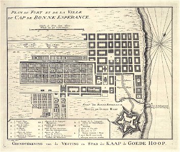
Map of Cape Town and the fort De Goede Hoop (Good Hope), Jakob van der Schley, 1747
Map of cape town and the fort de goede hoop. -grondtekening van de vesting en stad der kaap de goede hoop. Plan du fort et de la ville du cap de bonne esperance. Key: a. Grande place. / groote plaats. / b. Place de l'eglise. / kerk-plyn. / c. Le temple. / de kerk. / d. Maison des esclaves. / slaave-wooning. / e. Hopital de la compagnie. / hospitaal. / ff. Magasins de la compagnie. / magazynen. / g. Boucherie de la compagnie. / vleezhal. / h. Hotel de sous gouverneur. / huiz des ondergoeverneurs. / i. Maison du fiscal. / huiz des fiskaals. / k. Maison de plaisance du gouverneur. / lusthuiz des goeverneurs. / l. Ecuriers de la compagnie. / stallen der maatschappye. / m. Reservoir. / waterbak. / n. Tuyayx ou l'on fuit l'eu pour les v:rs. / buizen voerende 't water aan 't hoofd, waarvan de scheepen voorzien worden. Date: 1747. Dimensions: height: 25.5 cm (10 in); width: 20.5 cm (8 in). Medium: engraving on paper. Collection: Koninklijke Bibliotheek. AMH-7961-KB Map of Cape Town and the fort De Goede Hoop (Good Hope)