Log in
All resources
Create a design
27,441 Free Images of Maps
bibliothèque nationale de france
maps by willem and johannes blaeu
eran laor cartographic collection
koninklijke bibliotheek
maps by jakob van der schley
engraving on paper
jakob van der schley
english-language maps
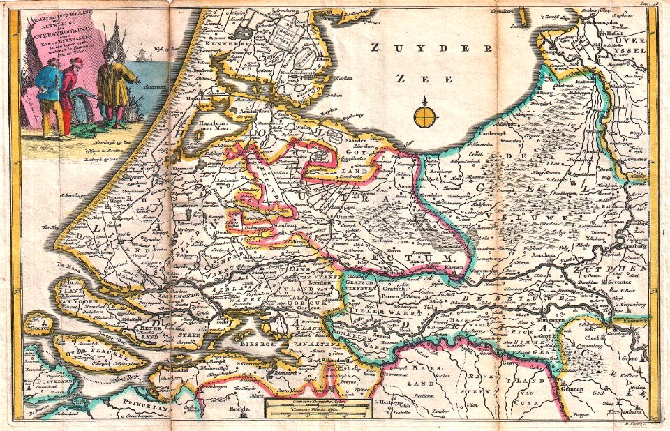
gemeente atlas van nederland - south holland
1860s maps of south holland
maps from the earth and its inhabitants, vol. xii
africa in the 1890s
prints by cornelius drebbel
old maps of alkmaar
maps by willem and johannes blaeu
pisco, peru
john rocque's 1746 map of london
maps by john pine
eran laor cartographic collection
john cary
eran laor cartographic collection
romeyn de hooghe
palace of westminster in art
floor plans of palaces
1610s maps of the netherlands
maps with cartouches
prints by agostino veneziano in the british museum
maps in the british museum
prints by agostino veneziano in the british museum
maps in the british museum
maps from the mechanical curator collection available to georeference
maps from the mechanical curator collection
maps from the mechanical curator collection
icelandic-language maps showing history
maps of paris by bernard-jean-hyacinthe jaillot
maps of paris from paris musées
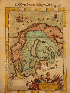
17th-century maps of finland
1680s maps of norway
eran laor cartographic collection
emanuel bowen
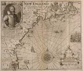
the generall historie of virginia (john smith)
1624 engravings
maps in the library of congress
old maps of france
charles frederick cheffins
railway lines in egypt
maps of spain by tomas lopez
1761 maps of spain
17th-century maps of france
old maps of île de ré
democritus by velazquez
baroque
curt teich postcard archives
maps of new mexico
maps of the west-indische compagnie
old maps of dutch brazil
west seram regency
johannes nessel
1665 maps of ukraine
1665 maps
history of tennessee
battle of belmont
maps of polders in south holland
17th-century maps of rotterdam
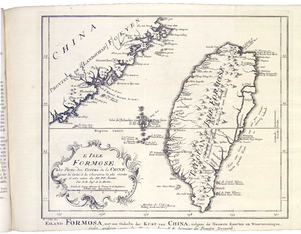
1740s maps of taiwan
1749 maps of asia
victor levasseur - maps of france
19th-century maps of finistère
maps of the duchy of mantua
guillaume sanson
maps in the library of congress
1763 maps of north america
maps in the library of congress
1862 maps of virginia
russo-turkish war (1877–1878) in art
great eastern crisis (1875–78)
1941 watercolor paintings
works by eric ravilious
daniel friedrich sotzmann
old maps of pomerania
maps by willem and johannes blaeu
maps of tiel
turgot map of paris – derivative files
hôtel de ratabon
romanticism,neoclassicism
1852 maps of france
bird's eye view maps of vermont
history of bennington, vermont
maps in the british museum
old maps of dunkerque
old maps of algiers
maps from gallica
bodleian maps collection
old maps of oxford
old maps of the viceroyalty of peru
old maps of peru
maps of paris from bibliothèque nationale de france
nouveau plan de paris by louis brion de la tour
maps by pieter van der keere
old maps of north brabant
maps from the earth and its inhabitants, vol. vii
charles eugène perron
maps from the earth and its inhabitants, vol. vi
old maps of kyrgyzstan
maps from the earth and its inhabitants, vol. iv
falkirk
maps from the earth and its inhabitants, vol. vi
old maps of kyrgyzstan
atlas van der hagen (volume 4)
atlas van der hagen
gemeente atlas van nederland - south holland
old maps of vlaardingen
maps of lidingö
1781 in sweden
gemeente atlas van nederland - south holland
1860s maps of south holland
ray in the 19th century
iran in the 1820s
gemeente atlas van nederland - south holland
1860s maps of south holland
perusinus ac tifernas (galleria delle carte geografiche)
ignazio danti
gemeente atlas van nederland - south holland
1860s maps of south holland
gemeente atlas van nederland - south holland
1860s maps of south holland
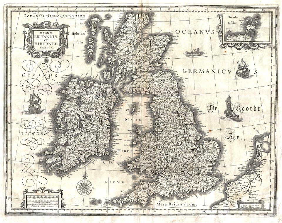
17th-century maps of the british isles
maps by willem and johannes blaeu
guide joanne espagne et portugal-1915
1915 maps
maps of braga by braun & hogenberg
braga
maps of oradea by braun & hogenberg
medieval fortification
maps by willem and johannes blaeu
old maps of jan mayen
old maps of manhattan, new york city
1851 maps
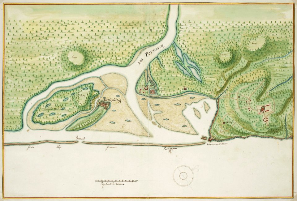
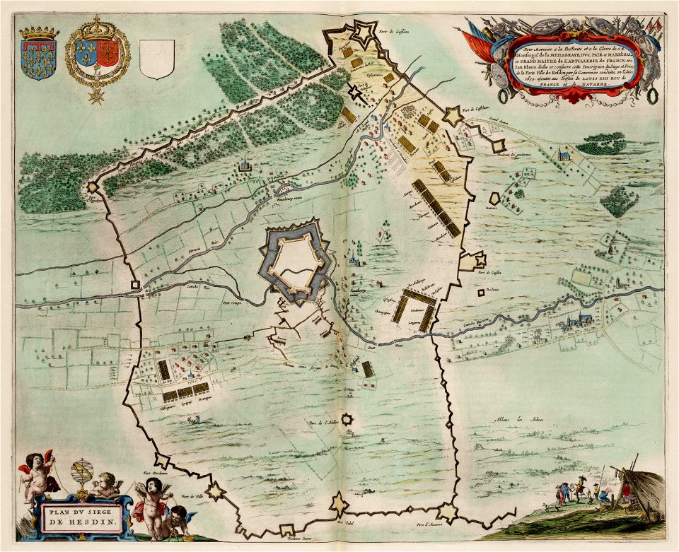
maps of hesdin city walls
maps of sieges
eran laor cartographic collection
johannes condet
maps by willem and johannes blaeu
maps made in the 17th century
media contributed by cleveland public library
georg widmann
maps of tangier by braun & hogenberg
maps of asilah by braun & hogenberg
maps of tangier by braun & hogenberg
maps of asilah by braun & hogenberg
maps from the earth and its inhabitants, vol. xii
1892 in africa
maps from the earth and its inhabitants, vol. iv
topographic maps of scotland
maps from the earth and its inhabitants, vol. vii
dungan revolt
1596 engravings
renaissance
eran laor cartographic collection
john cary
emery walker
1911 maps
maps of barbary coast
old maps of tartary
eran laor cartographic collection
edward weller
eran laor cartographic collection
john cary
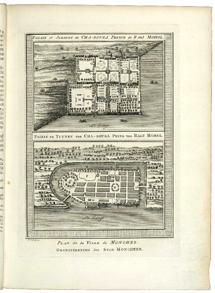
maps of the dutch east india company - korea
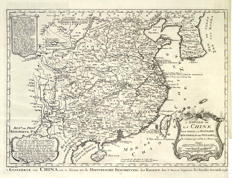
maps of the dutch east india company - china
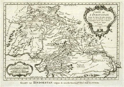
maps of the dutch east india company - india
1755 maps
maps of the dutch east india company - indonesia
maps by jakob van der schley
maps of the dutch east india company - india
1755 maps
old maps of the dutch east india company
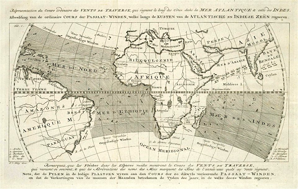
1760s maps of the atlantic ocean
sion, quarter of rijswijk
1712 maps
map of the circle of austria by sanson
1690s maps of austria
map of the circle of austria by sanson
1700s maps of austria
gaspard de chabrol
maps from gallica
maps by willem and johannes blaeu
coats of arms on maps
maps by willem and johannes blaeu
old maps of overijssel
maps of brest from bibliothèque nationale de france
maps from gallica
oranienburger straße (berlin-mitte)
paintings by eduard hildebrandt
19th-century double hemisphere world maps
1800s maps of the world
maps in the library of congress
1886 maps of massachusetts
maps of the divisions of the polish-lithuanian commonwealth
karol de perthées
maps of the divisions of the polish-lithuanian commonwealth
karol de perthées
maps of paris from the david rumsey historical map collection
romanticism
15th-century maps of africa
fra mauro map details
1720s maps of the netherlands
1726 maps
tourism advertising posters of germany
1935 maps of germany
2901 - 3000 of 27,441
Next page
/ 275