Map of the mouth of the Pousioucq River, Johannes Vingboons, circa 1665

Map of the mouth of the Pousioucq River, Johannes Vingboons, circa 1665

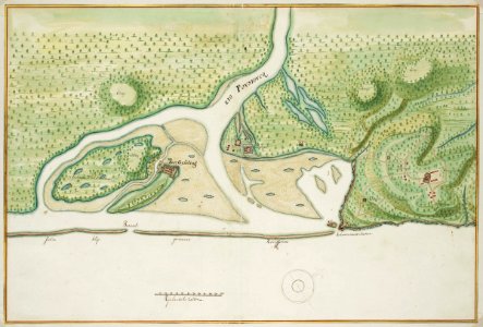
Title in the leupe catalogue (na): kaart van de monding van de "rio pousioucq" in brazilië met het fort gijseling en de andere nederlandsche versterkingen. Map of the mouth of the pousioucq river. Remarks: this map is contained in the vingboons atlas. Cf. Koninklijke bibliotheek, the hague, inv. Nr. 1043 b 14, after p. 136 no. 36. Cf. Nationaal archief, the hague, inv. Nr. Vel0714 and vel0715. Date: circa 1665. Dimensions: height: 62 cm (24.4 in); width: 42 cm (16.5 in). Medium: watercolour on paper. Collection: Nationaal Archief. AMH-6793-NA Map of the mouth of the Pousioucq River
Edit image
Published by:
Creazilla
Author: Johannes VingboonsSource: commons.wikimedia.org

Loading...

0 downloads
Loading...
maps of the west-indische compagnieold maps of dutch brazil1665atlas vingboonswatercolor drawings by johannes vingboonswatercolour on papernationaal archiefjohannes vingboons

MORE LIKE THIS

Creazilla logo
Over 10 million free graphic resources for content creators and designers.
© 2018 - 2025 Creazilla
Our resourcesAll imagesPhotosDigital illustrationsClipartIconsPNG ImagesEmojisSilhouettesTraditional Art3D ModelsVectorsFontsColor namesColor palettesGradientsAudioAnimationVideosTemplates
InformationAbout CreazillaTerms of useTech teamPrivacy policyLicence Information
FeedbackContact Us