Map of Formosa, Jakob van der Schley, 1749

Map of Formosa, Jakob van der Schley, 1749

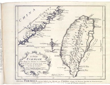
Map of formosa. Eiland formosa, met een gedeelte der kust van china, volgens de nieuwste kaarten en waarneemingen, onder anderen [?] n. B. Ingenieur des fransen zeevaards. L'isle formose et partie des costes de la chine suivant les carets et les observations les plus récentes et entre autres des rr. Pp. Jesuites. Par n. B. In:r de la marine. The voc fort of zeelandia is indicated on the map as ruine. Vernield. The fort on the island of kelang is referred to in the same way. Date: 1749. Dimensions: height: 24 cm (9.4 in); width: 18.5 cm (7.2 in). Medium: engraving on paper. Collection: Koninklijke Bibliotheek. AMH-7971-KB Map of Formosa
Edit image
Published by:
Creazilla
Author: Jacques-Nicolas BellinSource: commons.wikimedia.org

Loading...

1 download
Loading...
1749 maps of asia1740s maps of taiwanmaps by jakob van der schleymaps of the dutch east india company - taiwanengraving on paperkoninklijke bibliotheekjakob van der schley

MORE LIKE THIS

Creazilla logo
Over 10 million free graphic resources for content creators and designers.
© 2018 - 2025 Creazilla
Our resourcesAll imagesPhotosDigital illustrationsClipartIconsPNG ImagesEmojisSilhouettesTraditional Art3D ModelsVectorsFontsColor namesColor palettesGradientsAudioAnimationVideosTemplates
InformationAbout CreazillaTerms of useTech teamPrivacy policyLicence Information
FeedbackContact Us