Log in
All resources
Create a design
26,489 Free Artworks of Map
bibliothèque nationale de france
maps in the library of congress
atlas novus (blaeu)
joan blaeu
eran laor cartographic collection
copper engraving print
british library
gemeente atlas van nederland - south holland
1860s maps of south holland
description de l'universe
guide joanne normandie-1912
1912 maps of france
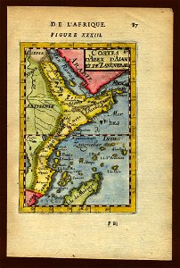
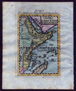
old maps of zanzibar
zanzibar in art
old maps of zanzibar
zanzibar in art
island of california on world maps
1680s maps of the world
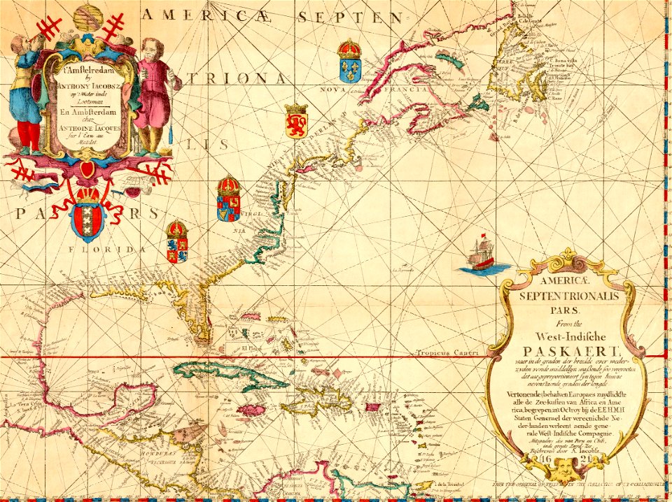
maps of the west-indische compagnie
1770 maps
maps in the library of congress
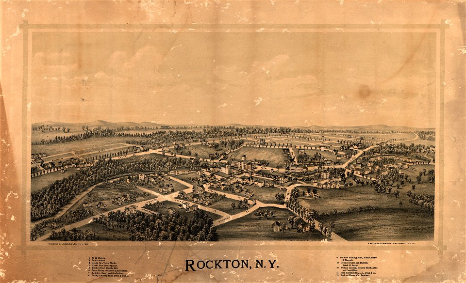
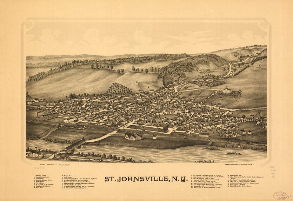
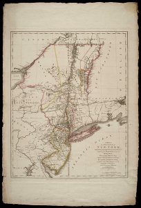
1890 maps of new york (state)
maps by willem and johannes blaeu
safavid dynasty
maps of the west-indische compagnie
maps by claude joseph sauthier
maps by girolamo porro
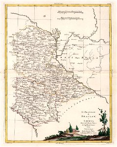
1598 maps of russia
lithographs of paris
floor plans of paris
maps of paris from bibliothèque nationale de france
johannes de ram
smedslätten
ålsten
maps in the library of congress
1650s maps of cuba
atlas des anciens plans de paris by imprimerie nationale, 1900 from the david rumsey historical map collection
maps of paris from the david rumsey historical map collection
atlas des anciens plans de paris by imprimerie nationale, 1900 from the david rumsey historical map collection
maps of paris from the david rumsey historical map collection
old town vrana (zadar county)
matteo pagano della fede
liber qvartvs contrafactur vnd beschreibung von den vornembsten stten der welt (zzk 0.32)
patrimonium 2 (project)
juan de la cruz cano y olmedilla
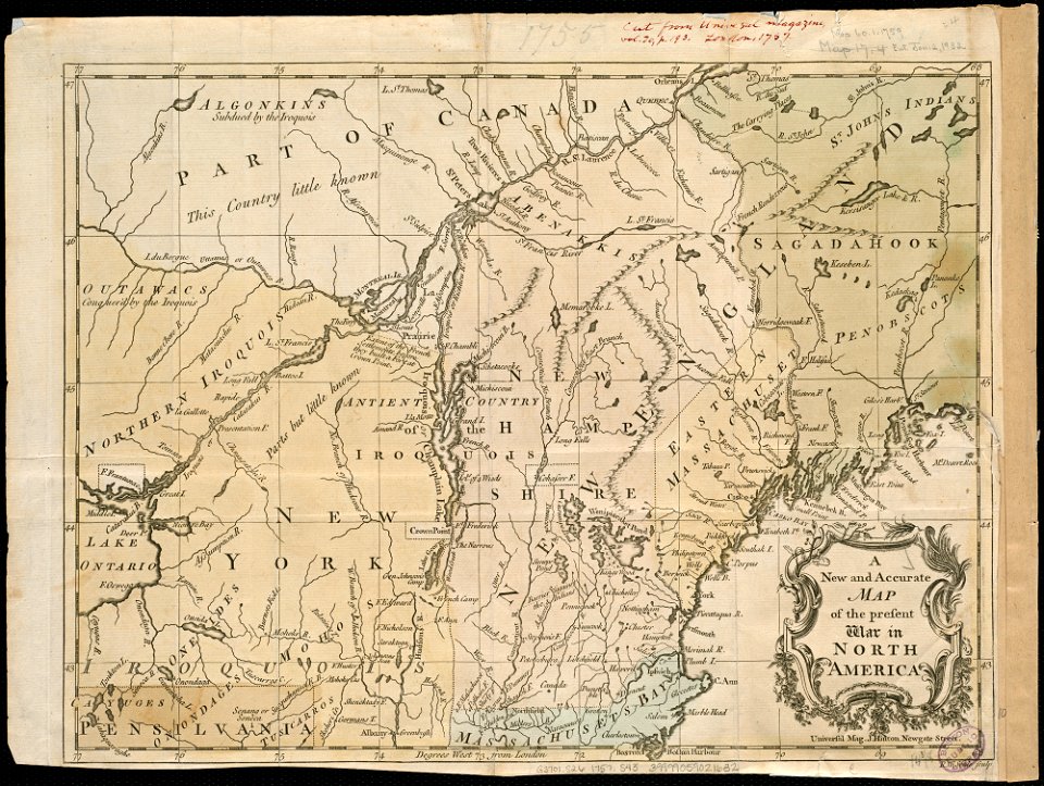
1755 maps of north america
liber qvartvs contrafactur vnd beschreibung von den vornembsten stten der welt (zzk 0.32)
patrimonium 2 (project)
files based of data provided by the czech office for surveying and cadastre
romantic music
danubius pannonico-mysicus
1726 maps
john rocque's 1746 map of london
maps of woolwich
maps of galicia by mercator-hondius
1619 maps
maps of spain by tomas lopez
1780 maps of spain
maps from the earth and its inhabitants, vol. xi
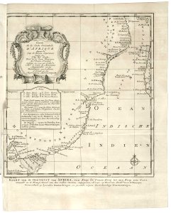
old maps of the sahara
antoine-françois tardieu
maps from gallica
maps from géographie illustrée de la france et de ses colonies
1868 maps
old maps of north holland
old maps of kennemerland
maps of antwerp by braun & hogenberg
maps of antwerp city walls
18th-century maps of the aegean sea
1780s maps of greece
jodocus hondius ii, nova totius terrarum orbis geographica ac hydrographica tabula, 1636
eran laor cartographic collection
maps of the western ghats
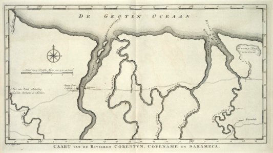
maps of rivers of india
19th-century satirical maps
1878 in art
turgot map of paris, kyoto university library – derivative files
palais royal (1634–1763)
maps by hendrik hondius the younger
1641 maps
1640s maps of the tsardom of russia
national coat of arms of russia
maps by emanuel bowen
britannia depicta
maps of uppland
1645 in sweden
maps by willem and johannes blaeu
monsters on maps
1600 world map by girolamo porro
1600s maps of the world
maps from the earth and its inhabitants, vol. vi
1891 maps of georgia
maps showing 18th-century history
maps made in the 18th century
atlas maior, vol 10 (spain and africa) - joan blaeu, 1667 - bl 114.h(star).10
1667 maps of europe
1660s maps of spain
1667 maps
atlas maior, vol 2 (sweden, russia, poland, eastern europe, and greece) - joan blaeu, 1667 - bl 114.h(star).2
17th-century maps of estonia
1660s maps of spain
1667 maps
maps of asia by jean-baptiste bourguignon d'anville
french-language maps
old maps of hannover
1757 in hannover
1800s maps of egypt
maps by john cary
maps from university of amsterdam special collections
atlas der neederlanden
1801 map of turkey in asia by john cary
1801 maps of the ottoman empire
maps of spain by tomas lopez
history of gipuzkoa
old maps of saxony from deutsche fotothek
1630s maps of saxony
historical images of the place dauphine (paris)
place dauphine on maps
17th-century maps of the mediterranean sea
golfe de saint-tropez
maps in the library of congress
1889 maps of michigan
gemeente atlas van nederland - south holland
1860s maps of south holland
maps of paris from bibliothèque nationale de france
fourth map of paris from traité de la police
maps of carmel valley, california
james meadows
old maps of north holland
maps of west friesland
illustrations from the mysterious island by jules férat
maps of the mysterious island
maps from the mechanical curator collection available to georeference
maps from the mechanical curator collection
ptolemy's 4th african map
1477 maps
maps in the library of congress
animals on maps
1910s maps of europe
guides joanne
history of yokohama
maps of yokohama
athens in the ottoman era
old maps of athens
maps of paris from the david rumsey historical map collection
romanticism
1906 maps of europe
1906 in spain
1906 maps of europe
1906 in spain
maps from the mechanical curator collection available to georeference
maps from the mechanical curator collection
old maps of the dutch east india company - africa
maps of the dutch east india company - mozambique
old maps of the carolingian empire
atlas van loon
maps of territories in the burgundian circle
17th-century maps of the north sea
atlas van loon
1664 maps
turgot map of paris – derivative files
château de la tournelle (paris)
maps of the ottoman empire by mercator-hondius
eran laor cartographic collection
maps of the ottoman empire by mercator-hondius
eran laor cartographic collection
eran laor cartographic collection
german renaissance,humanism
maps by hendrik hondius the younger
1640s maps of the world
gemeente atlas van nederland - south holland
1860s maps of south holland
gemeente atlas van nederland - south holland
1860s maps of south holland
gemeente atlas van nederland - south holland
19th-century maps of rotterdam
1620s maps of north america
1620s maps of the caribbean
old maps of the united states from the norman b. leventhal map center
old maps of canada from the norman b. leventhal map center
maps in the library of congress
1890 maps of new york (state)
holy roman empire
pierre mortier
antoine-françois tardieu
maps from gallica
maps by pieter van der keere
maps by abraham ortelius
maps of the battle of gettysburg
p.s. duval & son
national museum of maps and rare books, bucharest
maps by abraham ortelius
old maps of the bay of gibraltar
18th-century maps of gibraltar
works of nathaniel dearborn
1850s maps of boston
17th-century maps of denmark
old maps of seas
17th-century maps of france
old maps of loiret
italian-language maps
1781 maps of ukraine
maps showing history of the early middle ages
charles the bald
maps of paris from the princeton university library
1750s maps of paris
17th-century maps of silesia
coats of arms on maps
19th-century maps of greece
pierre françois tardieu
1601 - 1700 of 26,489
Next page
/ 265

![[Map of a part of the island of Cuba and of the Bahamas]., Johannes Vingboons, 1650](https://cdn.creazilla.com/illustrations/7019884/map-of-a-part-of-the-island-of-cuba-and-of-the-bahamas-loc-00560610-illustration-md.jpeg)