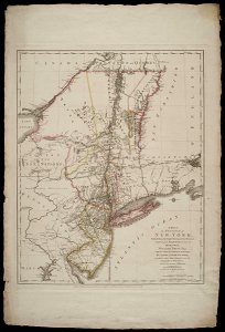
Map of the area around New York, Claude Joseph Sauthier, 1 August 1776
Map of the area around new york. Title in the leupe catalogue (na): a map of the province of new-york etc. To which is added new-jersey etc. A map of the province of new-york, / reduc'd from the large drawing of that province, compiled from actual surveys by order of / his excellency / william tryon es:r / captain general & governor of the same, by claude joseph sauthier; to which is added new-jersey. Date: 1 August 1776. Dimensions: height: 99.1 cm (39 in); width: 66.5 cm (26.1 in). Medium: coloured engraving on paper. Collection: Nationaal Archief. AMH-8622-NA Map of the area around New York