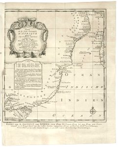
Map of the east coast of Africa, from the Cape of Good Hope to the Cape del Gada, Jakob van der Schley, circa 1747
Map of the east coast of africa, from the cape of good hope to the cape del gada. Kaart van de oostkust van afrika, van kaap de goede hoop tot aan kaap del gada. Carte / de la coste orientale / d'afrique / depuis le / cap de bonne esperance / jusq'au / cap del gada. The map has been copied from a french chart of 1740. Bottom left the abbreviations used are set out and explained. Date: circa 1747. Dimensions: height: 25.5 cm (10 in); width: 32 cm (12.5 in). Medium: engraving on paper. Collection: Koninklijke Bibliotheek. AMH-7884-KB Map of the east coast of Africa, from the Cape of Good Hope to the Cape del Gada