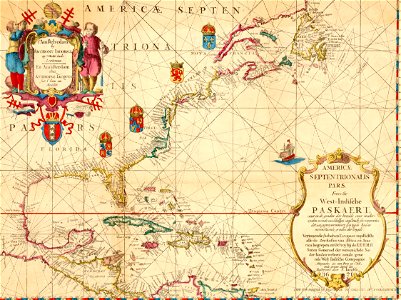
Historisch Nordamerika (cropped), Francis D'Avignon, 1621

Historisch Nordamerika (cropped), Francis D'Avignon, 1621

Old map of north america, the caribbean, and northern south america; covers area north from venezuela to labrador; includes decorative cartouches and illustrations. This is a facsimile, from the original on vellum in the collection of e. B. O'callaghan lld. Full title of map: americæ septentrionalis pars: from the west-indische paskaert; waer in de graden der breedde over wederzyden vande middellyn waßende soo vergrooten dat die geproportioneert syn tegen hunne nevenstaende graden der lengde from: o'callaghan, e. B. , ed. (1856) documents relative to the colonial history of the state of new york, i, albany, n. Y. : legislature of the state of new york. Date: 1621.
Edit image
Published by:
Creazilla
Author: Anthoni Jacobsz (1594-1624), cartographerFrancis D'Avignon (1813–1875), lithographerE.B. (Edmund Bailey) O'Callaghan (1797–1880), collectorSource: commons.wikimedia.org

Loading...

0 downloads
Loading...
1620s maps of north america1620s maps of the caribbeanedmund bailey o'callaghanfrancis d'avignonnorth americahistory of north americaterritorial evolution of north america prior to 1763

MORE LIKE THIS

Creazilla logo
Over 10 million free graphic resources for content creators and designers.
© 2018 - 2025 Creazilla
Our resourcesAll imagesPhotosDigital illustrationsClipartIconsPNG ImagesEmojisSilhouettesTraditional Art3D ModelsVectorsFontsColor namesColor palettesGradientsAudioAnimationVideosTemplates
InformationAbout CreazillaTerms of useTech teamPrivacy policyLicence Information
FeedbackContact Us