Log in
All resources
Create a design
26,489 Free Artworks of Map
bibliothèque nationale de france
tresor des cartes geographiques (1659)
beschreibung und contrafactur der vornembster stät der welt, liber primus civitates orbis terrarum
maps from the earth and its inhabitants, vol. iv
géographie générale; physique, politique et économique (1876)
eran laor cartographic collection
maps from the earth and its inhabitants, vol. x
hendrik de leth
claes janszoon visscher ii
1880s maps of egypt
algiers in the 19th century
old maps of algiers
the antiquities of england and wales (1773)
1784 fleurons
media from regionaal archief alkmaar
maps of barsingerhorn
1771 maps of asia
andrew dury
the earth and its inhabitants, vol. xii: africa, vol. iii
canary islands in the 1890s
gemeente atlas van nederland - south holland
maps of moerkapelle
eran laor cartographic collection
maps of prague by joris hoefnagel
the antiquities of england and wales (1773)
1784 fleurons
atlas des anciens plans de paris by imprimerie nationale, 1880 from bhvp
plan de roussel
gemeente atlas van nederland - north holland
maps of bussum
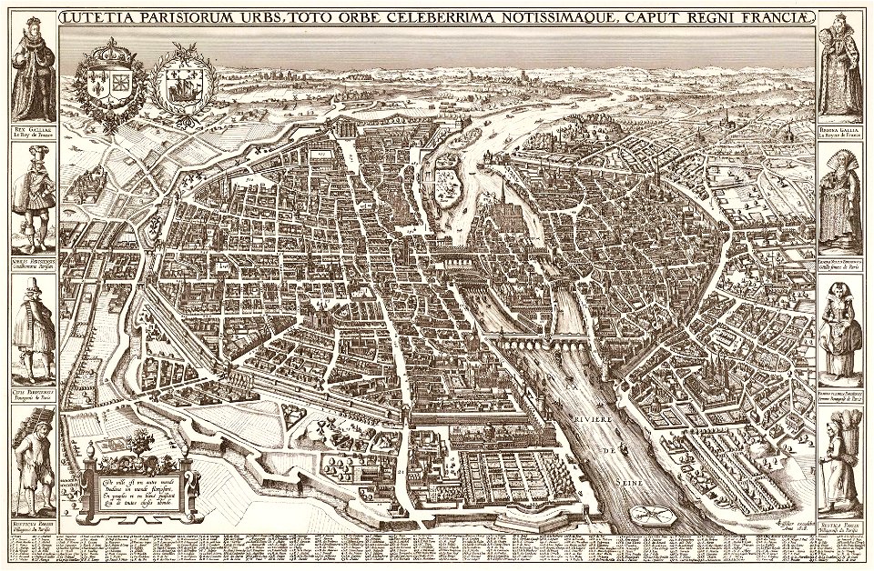
map of paris by claes jansz. visscher
bird's eye view maps of paris
map of paris by claes jansz. visscher
bird's eye view maps of paris
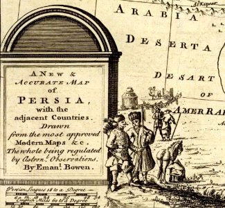
1747 persia map by emanuel bowen
cartouche (cartography)
maps from the earth and its inhabitants, vol. iv
old maps of cardiff
maps from the earth and its inhabitants, vol. x
1880s maps of egypt
maps from the earth and its inhabitants, vol. iv
19th-century maps of surrey
géographie générale; physique, politique et économique (1876)
1876 maps of germany
géographie générale; physique, politique et économique (1876)
1876 maps of germany
géographie générale; physique, politique et économique (1876)
old maps of the pyrenees
géographie générale; physique, politique et économique (1876)
1876 maps of india
géographie générale; physique, politique et économique (1876)
1870s maps of liguria
the history and antiquities of the parish of lambeth, and the archiepiscopal palace (1827)
1820s maps of london
19th-century maps of somalia
1876 maps of africa
maps from the earth and its inhabitants, vol. iv
maps of penzance
maps from the earth and its inhabitants, vol. x
1880s maps of egypt
19th-century maps of nicaragua
1870s maps of central america
maps from the earth and its inhabitants, vol. iv
1880s maps of london
maps from the earth and its inhabitants, vol. x
1880s maps of egypt
old maps of finnmark
1890s maps of norway
maps from the earth and its inhabitants, vol. x
1886 maps of africa
maps from the earth and its inhabitants, vol. iv
maps of balmoral castle
maps of the west-indische compagnie
1750 maps
het zegepralent kennemerlant
hendrik de leth
maps of country estates in the netherlands
het zegepralent kennemerlant
eran laor cartographic collection
claes jansz. visscher (ii)
eran laor cartographic collection
guillaume sanson
eran laor cartographic collection
michel van lochom
antoine-françois tardieu
jean-baptiste poirson
plan de dheulland - derivatives files
ruisseau de ménilmontant
carte des côtes de malabar et de coromandel (1723)
philippe buache
tresor des cartes geographiques (1659)
1650s maps of iran
bibliothèque nationale de france
sanson map of lorraine
beschreibung und contrafactur der vornembster stät der welt, liber primus civitates orbis terrarum
maps of genoa by braun & hogenberg
beschreibung und contrafactur der vornembster stät der welt, liber primus civitates orbis terrarum
maps of rhodes by braun & hogenberg
beschreibung und contrafactur der vornembster stät der welt, liber primus civitates orbis terrarum
maps of montpellier by braun & hogenberg
tresor des cartes geographiques (1659)
1650s maps of portugal
beschreibung und contrafactur der vornembster stät der welt, liber primus civitates orbis terrarum
maps of lübeck by braun & hogenberg
tresor des cartes geographiques (1659)
1650s maps of the americas
tresor des cartes geographiques (1659)
1650s maps of denmark
tresor des cartes geographiques (1659)
1650s maps of ethiopia
tresor des cartes geographiques (1659)
1650s maps of china
bibliothèque nationale de france
sanson map of lorraine
beschreibung und contrafactur der vornembster stät der welt, liber primus civitates orbis terrarum
maps of toledo by braun & hogenberg
tresor des cartes geographiques (1659)
1650s maps of france
beschreibung und contrafactur der vornembster stät der welt, liber primus civitates orbis terrarum
maps of écija by braun & hogenberg
tresor des cartes geographiques (1659)
1650s maps of asia
beschreibung und contrafactur der vornembster stät der welt, liber primus civitates orbis terrarum
maps of wittenberg by braun & hogenberg
beschreibung und contrafactur der vornembster stät der welt, liber primus civitates orbis terrarum
maps of vienna by braun & hogenberg
tresor des cartes geographiques (1659)
1650s maps of italy
beschreibung und contrafactur der vornembster stät der welt, liber primus civitates orbis terrarum
maps of kassel by braun & hogenberg
beschreibung und contrafactur der vornembster stät der welt, liber primus civitates orbis terrarum
maps of würzburg by braun & hogenberg
tresor des cartes geographiques (1659)
1659 maps of africa
tresor des cartes geographiques (1659)
1659 maps of europe
beschreibung und contrafactur der vornembster stät der welt, liber primus civitates orbis terrarum
maps of dresden by braun & hogenberg
beschreibung und contrafactur der vornembster stät der welt, liber primus civitates orbis terrarum
maps of brouwershaven by braun & hogenberg
tresor des cartes geographiques (1659)
1650s maps of greece
tresor des cartes geographiques (1659)
1650s maps of turkey
tresor des cartes geographiques (1659)
1650s maps of hungary
tresor des cartes geographiques (1659)
1650s maps of the americas
beschreibung und contrafactur der vornembster stät der welt, liber primus civitates orbis terrarum
maps of nîmes by braun & hogenberg
maps of the dutch east india company - sri lanka
1787
old maps of the strait of gibraltar
maps in the rijksmuseum amsterdam
maps from university of amsterdam special collections
atlas der neederlanden
the comprehensive history of england (1876)
english-language maps showing history
1877 maps of the united states
1870s maps of utah
historical collections of the state of new jersey (1852)
1850s maps of new jersey
atlas der neederlanden deel ix: algemeene kaarten & coloniën
maps from university of amsterdam special collections
old maps of galicia (spain)
1834 in galicia (spain)
bibliothèque nationale de france
maps of goa by linschoten
maps of flensburg by braun & hogenberg
johannistor (flensburg)
personifications of iran
britannia
old maps of the kingdom of naples
giovanni antonio rizzi zannoni
old maps of the strait of gibraltar
hendrik de leth
dutch 17th-century prints in the rijksmuseum amsterdam
maps by daniel stoopendaal
maps of hunsrück
jean hardy
old maps of delhi
catalan atlas
topographischer atlas der schweiz
eiger
old maps of the canton of zürich
türlersee
korte beschryvinghe (1686)
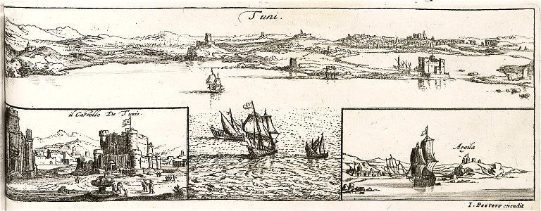
old maps of tunis
18th-century maps of istanbul
1771 maps of turkey
17th-century maps of the spanish empire
maps of the spanish netherlands
old maps of atlantis
island of california
prints from manesson travaux de mars at the peace palace library
old maps of brest from musée de bretagne
accademia delle scienze di torino - fondo millon
media from accademia delle scienze di torino
adriaan schoonebeek
emajõgi
postcards by erwin spindler
postcards of meißen
maps of uithuizermeeden
oldenzijl
bibliothèque nationale de france
maps by thomas kitchin
maps of mexico city by braun & hogenberg
maps of cusco by braun & hogenberg
maps by willem and johannes blaeu
1630s maps of asia
10301 - 10400 of 26,489
Next page
/ 265