Log in
All resources
Create a design
26,489 Free Artworks of Map
bibliothèque nationale de france
patrimonium 2 (project)
liber qvartvs contrafactur vnd beschreibung von den vornembsten stten der welt (zzk 0.32)
national library of poland
maps of paris from bibliothèque nationale de france
environs de paris levés géométriquement by jean delagrive (1731-1742)
africa in the 1890s
maps of africa
maps from the earth and its inhabitants, vol. xii
joan blaeu
old maps of amsterdam
hendrik de leth
1870s maps of kentucky
maps of the ohio river
dr. wilh. junker's reisen in afrika 1875-1886
old maps of lake victoria
manual of the corporation of the city of new york (1851)
maps from valentine's manual
elizabeth i of england (the ditchley portrait)
henry holiday
maps of ghent by braun & hogenberg
saigon during the french colonial period
citadel of saigon
gemeente atlas van nederland - limburg
old maps of venlo
gemeente atlas van nederland - north holland
ransdorp
bibliothèque nationale de france
maps of goa by linschoten
prints by mario cartaro
old maps of basilicata
paintings by christoph bernhard francke in the herzog anton ulrich-museum
portrait paintings in the herzog anton ulrich-museum
beschreibung und contrafactur der vornembster stät der welt, liber primus civitates orbis terrarum
maps of burgos by braun & hogenberg
gemeente atlas van nederland - gelderland
maps of renkum
map of maastricht by willem and johannes blaeu (1649)
statenkwartier (maastricht)
maps from the earth and its inhabitants, vol. xii
africa in the 1890s
environs de paris levés géométriquement by jean delagrive (1731-1742)
maps of paris from bibliothèque nationale de france
environs de paris levés géométriquement by jean delagrive (1731-1742)
maps of paris from bibliothèque nationale de france
maps from the earth and its inhabitants, vol. xii
africa in the 1890s
environs de paris levés géométriquement by jean delagrive (1731-1742)
maps of paris from bibliothèque nationale de france
africa in the 1890s
maps of africa
illustrations from the archipelago on fire by léon benett
old maps of greece
maps from the earth and its inhabitants, vol. x
1890s maps of the nile delta
maps from the earth and its inhabitants, vol. xii
africa in the 1890s
environs de paris levés géométriquement by jean delagrive (1731-1742)
maps of paris from bibliothèque nationale de france
maps from the earth and its inhabitants, vol. xi
africa in the 1890s
environs de paris levés géométriquement by jean delagrive (1731-1742)
maps of paris from bibliothèque nationale de france
environs de paris levés géométriquement by jean delagrive (1731-1742)
maps of paris from bibliothèque nationale de france
environs de paris levés géométriquement by jean delagrive (1731-1742)
maps of paris from bibliothèque nationale de france
1884 pacific typhoon season track maps
1884 in taiwan
illustrations from the archipelago on fire by léon benett
old maps of greece
environs de paris levés géométriquement by jean delagrive (1731-1742)
maps of paris from bibliothèque nationale de france
environs de paris levés géométriquement by jean delagrive (1731-1742)
maps of paris from bibliothèque nationale de france
maps from the earth and its inhabitants, vol. xii
africa in the 1890s
maps from the earth and its inhabitants, vol. xi
africa in the 1890s
maps from the earth and its inhabitants, vol. xiii
africa in the 1890s
bern city map of 1638 by matthäus merian
baroque
liber qvartvs contrafactur vnd beschreibung von den vornembsten stten der welt (zzk 0.32)
patrimonium 2 (project)
liber qvartvs contrafactur vnd beschreibung von den vornembsten stten der welt (zzk 0.32)
patrimonium 2 (project)
liber qvartvs contrafactur vnd beschreibung von den vornembsten stten der welt (zzk 0.32)
patrimonium 2 (project)
liber qvartvs contrafactur vnd beschreibung von den vornembsten stten der welt (zzk 0.32)
patrimonium 2 (project)
liber qvartvs contrafactur vnd beschreibung von den vornembsten stten der welt (zzk 0.32)
patrimonium 2 (project)
18th-century maps of nottinghamshire
maps in the british museum
liber qvartvs contrafactur vnd beschreibung von den vornembsten stten der welt (zzk 0.32)
patrimonium 2 (project)
liber qvartvs contrafactur vnd beschreibung von den vornembsten stten der welt (zzk 0.32)
patrimonium 2 (project)
liber qvartvs contrafactur vnd beschreibung von den vornembsten stten der welt (zzk 0.32)
patrimonium 2 (project)
maps of alsace by guillaume sanson
1660s maps of baden-württemberg
juan de la cruz cano y olmedilla
1750s maps of the caribbean
1760 maps of asia
baroque painting
liber qvartvs contrafactur vnd beschreibung von den vornembsten stten der welt (zzk 0.32)
patrimonium 2 (project)
liber qvartvs contrafactur vnd beschreibung von den vornembsten stten der welt (zzk 0.32)
patrimonium 2 (project)
liber qvartvs contrafactur vnd beschreibung von den vornembsten stten der welt (zzk 0.32)
patrimonium 2 (project)
liber qvartvs contrafactur vnd beschreibung von den vornembsten stten der welt (zzk 0.32)
patrimonium 2 (project)
liber qvartvs contrafactur vnd beschreibung von den vornembsten stten der welt (zzk 0.32)
patrimonium 2 (project)
civitates orbis terrarum. contrafactur und beschreibung von den vornembsten stetten der welt. liber tertius
maps of philippeville by braun & hogenberg
civitates orbis terrarum. contrafactur und beschreibung von den vornembsten stetten der welt. liber tertius
maps of arnhem by braun & hogenberg
civitates orbis terrarum. contrafactur und beschreibung von den vornembsten stetten der welt. liber tertius
maps of fortress of charlemont by braun & hogenberg
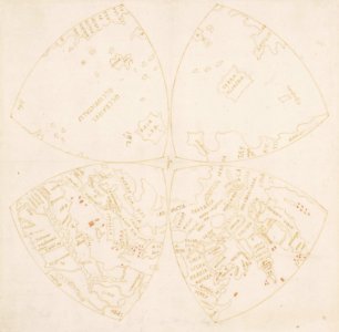
map of the northern hemisphere in four segments (rcin 991393)
high renaissance,renaissance
history of university of amsterdam
old maps of amsterdam
images of venice by jacopo de' barbari in the cleveland museum of art
details of images of venice by jacopo de' barbari
eran laor cartographic collection
willem albert bachiene
le antichità romane (piranesi)
neoclassicism
1806 maps of the united states
maps by john cary
1806 maps of the united states
maps by john cary
a voyage to abyssinia, and travels into the interior of that country, executed under the orders of the british government in the years 1809 & 1810
john outhett
maps from university of amsterdam special collections
atlas der neederlanden
high renaissance,renaissance
old maps of milan
a.de la motraye's travels through europe, asia, and into part of africa (1723) by la mottraye
realism
maps from encyclopædia britannica
emery walker
maps by willem and johannes blaeu
old maps of gelderland
maps of venlo by willem and johannes blaeu
joan blaeu
paintings in the rijksmuseum amsterdam
han van meegeren
maps in the stadsarchief amsterdam
prints by dirk jurriaan sluyter
media from regionaal archief alkmaar
maps of wieringerwaard
voyage pittoresque autour du monde (1822) by louis choris
old maps of the pacific ocean
demolished churches in de barbari map
san boldo (venice)
ceiling of the terrace of the geographical maps (uffizi gallery, florence)
mannerism
nouvelle géographie universelle, vol. ii
schematic maps of france
plenilunii lumina austriaca philippica
maps from gallica
portsmouth earthworks maps
squier and davis images
1560s maps of cyprus
giacomo franco
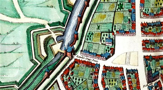
merian plan of paris - derivative files
baroque
turgot map of paris, kyoto university library – derivative files
enclos saint-lazare
atlas to accompany the official records of the union and confederate armies
everett d. graff collection of western americana
maps of cefala by braun & hogenberg
fort são caetano
lithographs in the rijksmuseum amsterdam
conrad leemans
arctic expeditions from british and foreign shores - from the earliest to the expedition of 1875 (1875)
1870s maps of canada
through the subarctic forest (1896) by pike
1890s maps of alaska
maps from the earth and its inhabitants, vol. xiv
maps of the southern ocean
the land of the monuments (1896)
old maps of the suez canal
scripture sites and scenes, from actual survey (1849)
1840s maps of palestine
description de l'universe
alain manesson mallet
scripture sites and scenes, from actual survey (1849)
maps of the temple mount
description de l'universe
alain manesson mallet
through the subarctic forest (1896) by pike
1890s maps of alaska
scripture sites and scenes, from actual survey (1849)
1840s maps of jerusalem
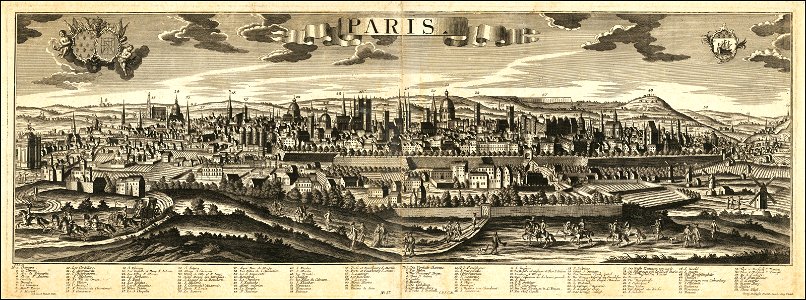
historical views of paris
1755 in paris
map of maastricht by willem and johannes blaeu (1649)
statenkwartier (maastricht)
maps of besançon by braun & hogenberg
eran laor cartographic collection
the antiquities of england and wales (1773)
1784 fleurons
10201 - 10300 of 26,489
Next page
/ 265