Log in
All resources
Create a design
26,489 Free Artworks of Map
eran laor cartographic collection
bibliothèque nationale de france
joan blaeu
latin-language maps
copper engraving print
british library
paper
british museum
sanson maps of north america
island of california
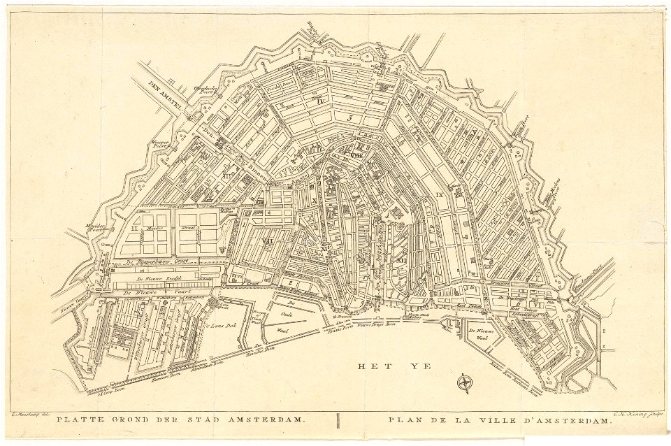
old maps of amsterdam
evert maaskamp
maps in the rijksmuseum amsterdam
1690s maps of the netherlands
corsica in the 20th century
guido colucci
san nicola in arcione
renaissance
maps of the iberian peninsula by mercator-hondius
maps by pieter van der keere
maps of the iberian peninsula by mercator-hondius
maps by pieter van der keere
maps of braga by braun & hogenberg
ceiling of the terrace of the geographical maps (uffizi gallery, florence)
maps by christian sgrothen
old maps of zeeland
ceiling of the terrace of the geographical maps (uffizi gallery, florence)
mannerism
ross township, butler county, ohio
hill forts in the united states
maps by willem and johannes blaeu
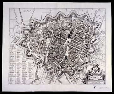
old maps of groningen (city)
curt teich postcard archives
leather postcards
maps by willem and johannes blaeu
old maps of friesland
second geological survey of pennsylvania report of progress ppp
james hall
curt teich postcard archives
map postcards
cartouche (cartography)
cornelis de jode
maps by willem and johannes blaeu
old maps of friesland
maps by willem and johannes blaeu
old maps of friesland
old maps of southeast asia
maps by isaak tirion
maps of aden by braun & hogenberg
aden
eran laor cartographic collection
giovanni maria cassini
library of congress artist posters collection
harper's magazine posters, 1895
claes jansz. visscher (ii)
atlas van stolk
eran laor cartographic collection
giovanni maria cassini
eran laor cartographic collection
francesco lamarra
eran laor cartographic collection
giovanni maria cassini
19th-century maps of groningen (province)
old maps of groningen (city)
maps in the library of congress
civitates orbis terrarvm
lawrence h. slaughter collection of english maps, charts, globes, books and atlases
covens en mortier
maps in the library of congress
civitates orbis terrarvm
maps in the library of congress
civitates orbis terrarvm
geographia universalis (1545) in the british museum
german renaissance,northern renaissance
maps of emden by braun & hogenberg
coats of arms of cirksena family
eran laor cartographic collection
willem blaeu
eran laor cartographic collection
gottfried hensel
eran laor cartographic collection
william henry toms
eran laor cartographic collection
gerard valck
eran laor cartographic collection
william hughes (geographer)
gemeente atlas van nederland - south holland
maps of nieuwerkerk aan den ijssel
eran laor cartographic collection
willem blaeu
eran laor cartographic collection
william hughes (geographer)
eran laor cartographic collection
hendrik hondius the younger
eran laor cartographic collection
pieter van der keere
broadsheet prints from koninklijke bibliotheek - maps
broadsheet prints from koninklijke bibliotheek
eran laor cartographic collection
pieter van der keere
eran laor cartographic collection
joan blaeu
pedro álvares cabral in art
discovery of brazil
sanson map of the german empire (17th century)
sanson maps of the circles of germany
maps of london by braun & hogenberg
maps in the british museum
sanson map of the german empire (17th century)
sanson maps of the circles of germany
pieter verbiest (ii)
maps from gallica
la virginea pars
paper
maps in the library of congress
1718 maps of north america
maps of london by braun & hogenberg
maps in the british museum
maps by alexis-hubert jaillot
old maps of duchy of cleves
la virginea pars
secotan
sanson map of the german empire (17th century)
sanson maps of the circles of germany
sanson map of the german empire (17th century)
sanson maps of the circles of germany
prints published by claes jansz. visscher (ii) in the rijksmuseum amsterdam
maps in the rijksmuseum amsterdam
maps showing history of indigenous peoples of north america
serpent mound
etienne fessard
rococo
notatki myśliwskie z afryki : somali (1897)
1890s maps of somalia
maps from gallica
guides joanne
sanson maps of north america
1690s maps of north america
1677 maps of north america
island of california
sanson maps of north america
island of california
sanson maps of north america
island of california
sanson maps of north america
island of california
maps from gallica
old maps of rouen
old maps of edinburgh
history of edinburgh
maps of paris from bibliothèque nationale de france
plan de roussel
maps by hendrik hondius the younger
old maps of overijssel
prints by ambrogio brambilla
old maps of parma
maps in the amsterdam museum
covens en mortier
atlas maior, vol 2 (sweden, russia, poland, eastern europe, and greece) - joan blaeu, 1667 - bl 114.h(star).2
1667 maps of russia
atlas maior, vol 4 (netherlands) - joan blaeu, 1667 - bl 114.h(star).4
1667 maps
atlas maior, vol 2 (sweden, russia, poland, eastern europe, and greece) - joan blaeu, 1667 - bl 114.h(star).2
1667 maps of russia
atlas maior, vol 1 (northern europe, norway, and denmark) - joan blaeu, 1667 - bl 114.h(star).1
1667 maps
atlas maior, vol 2 (sweden, russia, poland, eastern europe, and greece) - joan blaeu, 1667 - bl 114.h(star).2
17th-century maps of the aegean sea
atlas maior, vol 2 (sweden, russia, poland, eastern europe, and greece) - joan blaeu, 1667 - bl 114.h(star).2
maps of slavonia by gerardus mercator
atlas maior, vol 2 (sweden, russia, poland, eastern europe, and greece) - joan blaeu, 1667 - bl 114.h(star).2
copper engraving print
atlas maior, vol 3 (germany) - joan blaeu, 1667 - bl 114.h(star).3
17th-century maps of silesia
1575 illustrations
1575 prints
atlas maior, vol 1 (northern europe, norway, and denmark) - joan blaeu, 1667 - bl 114.h(star).1
1667 maps
maps of husum by braun & hogenberg
schloss vor husum
rivalry between cologne and düsseldorf
maps of cologne by braun & hogenberg
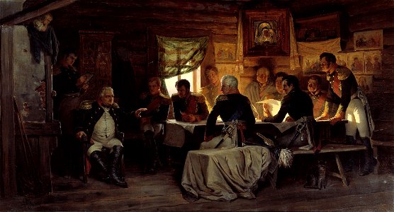
michael andreas barclay de tolly
mikhail kutuzov in portraits
engravings of topographia superioris saxoniae, thüringiae, misniae et lusatiae (merian)
baroque
description de l'universe
old maps of greece
maps from géographie illustrée de la france et de ses colonies
orientalist painting
map of paris by claes jansz. visscher - derivate files
abbaye sainte-geneviève de paris
maps of portugal by fernando álvares seco
theatrum orbis terrarum (1606 folger)
theatrum orbis terrarum (1606 folger)
maps of wales by humphrey llwyd
historical maps of crema
borgo san pietro (crema)
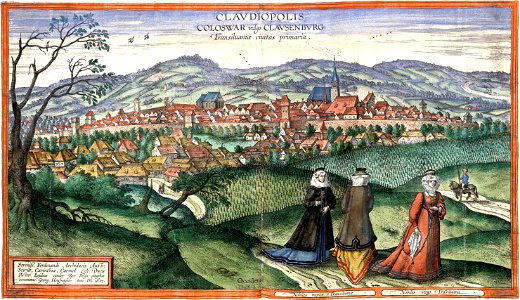
maps of cluj-napoca by braun & hogenberg
timeline of cluj-napoca
topographia franconiae (merian)
baroque
old maps of blankenberge
flandria illustrata
maps in the national library of australia
map of paris by claes jansz. visscher
atlas - voyage pittoresque à l'île-de-france, au cap de bonne-espérance et à l'île de ténériffe (1812) by milbert
maps from the mechanical curator collection
10401 - 10500 of 26,489
Next page
/ 265