Map for the fortification of the castle at Colombo, Carel Frederik Reimer, 1787

Map for the fortification of the castle at Colombo, Carel Frederik Reimer, 1787

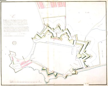
According to catalogue leupe (na), the original title reads: brouillon als voren, met eenige wijzigingen, referring to the title of vel0972: brouillon van een derde project ter verbetering en versterking der werken van colombo. Notes in the leupe catalogue: zie profieltekening behorende bij 3de project (=vel0973) zie ook vel0977 c; d en f. Derde project litt e. Commissie 1787. Notes on reverse: [blue label] nr. 15 versterking colombo; potlood nr. 536. Date: 1787. Dimensions: height: 64 cm (25.1 in); width: 51 cm (20 in). Medium: coloured drawing on paper. Collection: Nationaal Archief. AMH-4220-NA Map for the fortification of the castle at Colombo
Edit image
Published by:
Creazilla
Author: Carel Frederik ReimerSource: commons.wikimedia.org

Loading...

0 downloads
Loading...
maps of the dutch east india company - sri lanka1787carel frederik reimerfort (colombo)colombo in the 18th centurycoloured drawing on papernationaal archief

MORE LIKE THIS

Creazilla logo
Over 10 million free graphic resources for content creators and designers.
© 2018 - 2025 Creazilla
Our resourcesAll imagesPhotosDigital illustrationsClipartIconsPNG ImagesEmojisSilhouettesTraditional Art3D ModelsVectorsFontsColor namesColor palettesGradientsAudioAnimationVideosTemplates
InformationAbout CreazillaTerms of useTech teamPrivacy policyLicence Information
FeedbackContact Us