Log in
All resources
Create a design
47 Free Artworks of 1650s Maps Of France
bibliothèque nationale de france
tresor des cartes geographiques (1659)
philippe de la rué
1650s maps showing history
1650s maps of eastern europe
maps by jodocus hondius
maps by willem and johannes blaeu
maps of the byzantine levant
maps of ancient israel by philippe de la rué
patriarchates in jerusalem
claes jansz. visscher (i)
joannes van doetecum (i)
1650s maps of china
1655 maps of asia
maps of paris from the david rumsey historical map collection
maps of paris by caspar merian
tresor des cartes geographiques (1659)
old maps of the benelux
tresor des cartes geographiques (1659)
1650s maps of the tsardom of russia
tresor des cartes geographiques (1659)
1650s maps of eastern europe
17th-century maps of xaintonge
maps by jodocus hondius
old maps of nassau
salomon rogiers
collections of the blanton museum of art
maps by alexis-hubert jaillot
bibliothèque municipale de reims, rès. g 153
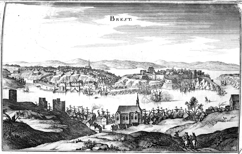
brest (france) in the 1650s
tresor des cartes geographiques (1659)
1650s maps of india
tresor des cartes geographiques (1659)
17th-century maps of silesia
17th-century maps of xaintonge
maps by jodocus hondius ii
1640s maps of hesse
old maps of nassau
tresor des cartes geographiques (1659)
1650s maps of france
robert gordon of straloch
1650s maps of scotland
1650s maps of the balkans
philippe de la rué
tresor des cartes geographiques (1659)
1650s maps of denmark
tresor des cartes geographiques (1659)
1650s maps of the americas
tresor des cartes geographiques (1659)
1650s maps of ethiopia
tresor des cartes geographiques (1659)
1650s maps of portugal
tresor des cartes geographiques (1659)
1650s maps of italy
tresor des cartes geographiques (1659)
1650s maps of iran
tresor des cartes geographiques (1659)
1650s maps of asia
tresor des cartes geographiques (1659)
1650s maps of the americas
tresor des cartes geographiques (1659)
1650s maps of greece
tresor des cartes geographiques (1659)
1650s maps of hungary
tresor des cartes geographiques (1659)
1650s maps of the iberian peninsula
tresor des cartes geographiques (1659)
1650s maps of the ottoman empire
tresor des cartes geographiques (1659)
1650s maps of the holy roman empire
cartes generales de toutes les parties du monde (1658)
1650s maps of saxony
maps of provence by pierre-jean de bompar
bibliothèque nationale de france
maps of the byzantine levant
1650s maps showing history
map of ancient assyria by philippe de la rué
old maps of mesopotamia
17th-century maps of west africa
1650 maps of africa
italia - di matteo greuter... - btv1b525056959
1650s maps of tuscany
maps by willem and johannes blaeu
bibliothèque nationale de france
map of the bosphorus strait by guillaume sanson (1665)
bibliothèque nationale de france
maps of ports and fortresses of the mediterranean by marco boschini (1651)
bibliothèque nationale de france
maps of abyssinia by mercator-hondius
bibliothèque nationale de france
maps of chios by braun & hogenberg
bibliothèque nationale de france
maps by willem and johannes blaeu
robert gordon of straloch
maps of ancient israel by philippe de la rué
old maps of ancient israel
bibliothèque nationale de france
maps of limousin by jean fayen
map of modern syria by philippe de la rué
1650s maps of palestine
maps of the byzantine levant
1650s maps showing history
1650s maps of switzerland
hans conrad gyger
1 - 47 of 47
/ 1


![Treasure of geographical maps of the main states of the universe [...], 1659](https://cdn.creazilla.com/illustrations/10000541161/treasure-of-geographical-maps-of-the-main-states-of-the-universe-1659-md.jpg)
![Treasure of geographical maps of the main states of the universe [...], 1659](https://cdn.creazilla.com/illustrations/10000302483/treasure-of-geographical-maps-of-the-main-states-of-the-universe-1659-md.jpg)


![Treasure of geographical maps of the main states of the universe [...], 1659](https://cdn.creazilla.com/illustrations/10000859170/treasure-of-geographical-maps-of-the-main-states-of-the-universe-1659-md.jpg)
![Treasure of geographical maps of the main states of the universe [...], 1659](https://cdn.creazilla.com/illustrations/10001054877/treasure-of-geographical-maps-of-the-main-states-of-the-universe-1659-md.jpg)
![Scotia antiqua, qualis priscis temporibus, Romanis praesertim, cognita fuit quam in lucem eruere conabatur / R. Gordonius a Straloch... [1653], 1654](https://cdn.creazilla.com/illustrations/10000806371/scotia-antiqua-qualis-priscis-temporibus-romanis-praesertim-cognita-fuit-quam-in-lucem-eruere-conabatur-r-gordonius-a-straloch-1653-1654-md.jpg)
![Treasure of geographical maps of the main states of the universe [...], 1659](https://cdn.creazilla.com/illustrations/10000314824/treasure-of-geographical-maps-of-the-main-states-of-the-universe-1659-md.jpg)
![Treasure of geographical maps of the main states of the universe [...], 1659](https://cdn.creazilla.com/illustrations/10000360844/treasure-of-geographical-maps-of-the-main-states-of-the-universe-1659-md.jpg)
![Treasure of geographical maps of the main states of the universe [...], 1659](https://cdn.creazilla.com/illustrations/10000659025/treasure-of-geographical-maps-of-the-main-states-of-the-universe-1659-md.jpg)
![Treasure of geographical maps of the main states of the universe [...], 1659](https://cdn.creazilla.com/illustrations/10001176342/treasure-of-geographical-maps-of-the-main-states-of-the-universe-1659-md.jpg)
![Treasure of geographical maps of the main states of the universe [...], 1659](https://cdn.creazilla.com/illustrations/10001567991/treasure-of-geographical-maps-of-the-main-states-of-the-universe-1659-md.jpg)
![Treasure of geographical maps of the main states of the universe [...], 1659](https://cdn.creazilla.com/illustrations/10000485227/treasure-of-geographical-maps-of-the-main-states-of-the-universe-1659-md.jpg)
![Treasure of geographical maps of the main states of the universe [...], 1659](https://cdn.creazilla.com/illustrations/10001567990/treasure-of-geographical-maps-of-the-main-states-of-the-universe-1659-md.jpg)


![Totius Lemovici et confinium provinciaru quantum ad dioecesin Lemovicensen [sic] spectant novissima et fidissima descriptio / aut. Jo. Fayano M.L., between 1600 and 1650](https://cdn.creazilla.com/illustrations/10000325692/totius-lemovici-et-confinium-provinciaru-quantum-ad-dioecesin-lemovicensen-sic-spectant-novissima-et-fidissima-descriptio-aut-jo-fayano-ml-between-1600-and-1650-md.jpg)

