Log in
All resources
Create a design
1,210 Free Artworks of Cartographers
eran laor cartographic collection
map
national library of israel
bibliothèque nationale de france
portrait
henricus hondius ii, nova totius terrarum orbis geographica ac hydrographica tabula, 1630
cartouche (cartography)
henricus hondius ii
maps of the ottoman empire by mercator-hondius
joan blaeu
eran laor cartographic collection
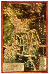
afbeeldinge der stad jerusalem
maps of the ottoman empire by mercator-hondius
eran laor cartographic collection
maps of the ottoman empire by mercator-hondius
eran laor cartographic collection
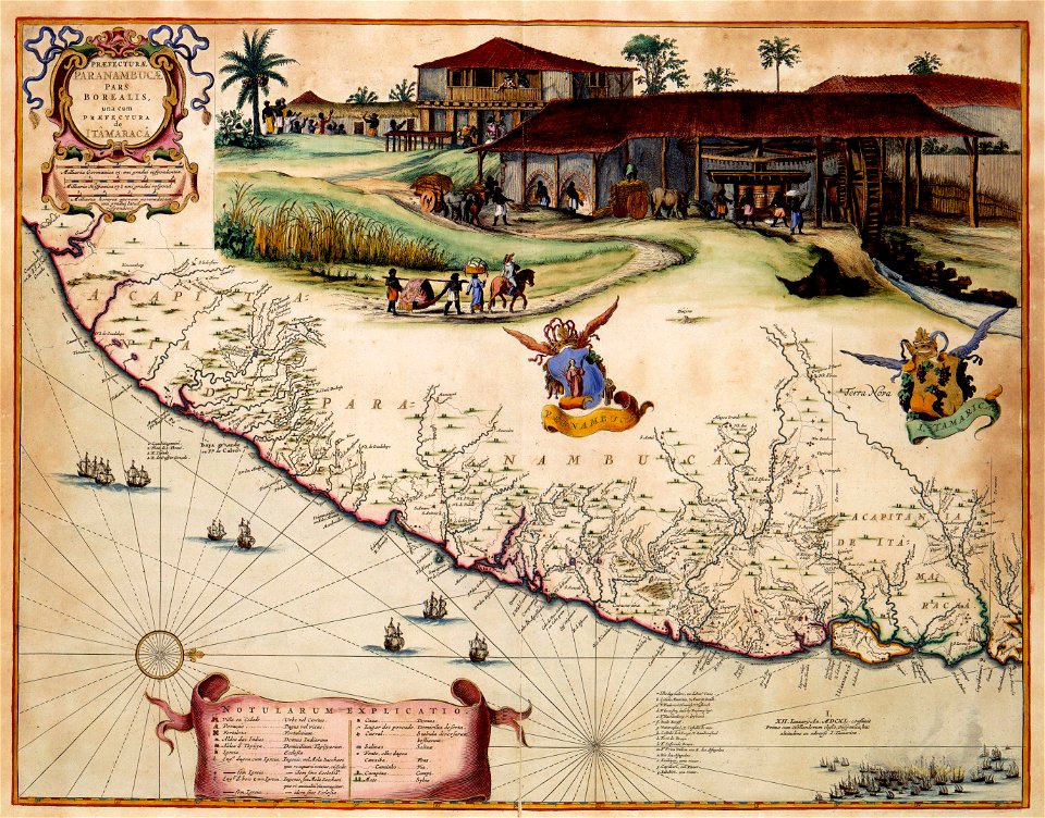
praefectura paranambucae pars borealis, una cum praefectura de itâmaracâ
georg marggraf
1704 works in germany
old maps of ulm
paintings by ferdinand georg waldmüller in the sonderauftrag linz
portraits by ferdinand georg waldmüller
maps by christian sgrothen
maps of rur
jean-henri bachofen
françois vuagnat
portrait of charles d'arenberg and anne de croy with their children attributed to frans pourbus (ii)
kasteel van arenberg
eran laor cartographic collection
afbeeldinge der stad jerusalem
maps of the ottoman empire by mercator-hondius
eran laor cartographic collection
maps by emanuel bowen
robert sayer
maps of the ottoman empire by mercator-hondius
eran laor cartographic collection
maps of the ottoman empire by mercator-hondius
eran laor cartographic collection
maps by christian sgrothen
old maps of the western hemisphere
jacob van meurs
old maps of brabant
1666 in belgium
cornell: persuasive cartography: the pj mode collection
cartographers
old maps of siena
duchy of castro
eran laor cartographic collection
frans van bleyswijck
nicolaus person
maps of hesse
het gulden cabinet
baroque
1760s maps of the americas
1764 maps
eran laor cartographic collection
18th-century maps of jerusalem
imagines professorum tubingensium
philipp apian
17th-century portraits of men at bust length
jodocus hondius
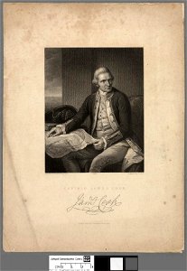
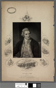
captain james cook (nathaniel dance - national maritime museum)
national library of wales portrait archive
portraits of sitting men
prints
paintings by francesco mingucci
historical images of cagli
national library of wales portrait archive
realism
captain james cook (nathaniel dance - national maritime museum)
national library of wales portrait archive
german renaissance,northern renaissance
engravings by samuel rawle
maps of abyssinia by mercator-hondius
national library of wales portrait archive
realism
luxoro atlas
maps by jacques-nicolas bellin
1752 maps
maps from the earth and its inhabitants, vol. vi
maps of samarkand
national library of wales portrait archive
realism
1780s maps of the balkans
carl schütz
maps by christian sgrothen
garzweiler
maps by emanuel bowen
robert sayer
1830s maps of switzerland
1834 maps of europe
atlas van der hagen (volume 4)
1660s maps of pernambuco
atlas van der hagen (volume 3)
atlas van der hagen
military cartographic institute (prague)
cultural monuments in bubeneč
1810s maps of the iberian peninsula
maps of spain by tomas lopez
posters by sergey ivanov
1920 posters of russia
portraits of francis drake
jodocus hondius
1780s maps of the americas
1786 maps
archiducatus austriae superioris descriptio facta anno 1667
machlandviertel
crux (constellation)
willem blaeu
luxoro atlas
old constellation maps
maps by samuel dunn
17th-century maps of southeast asia
maps by jodocus hondius
collections of the national library of israel
1725 maps
old maps of brabant
1666 in belgium
old maps of brabant
1666 in belgium
old maps of rhineland-palatinate
nicolaus person
collection cartographic documents from het utrechts archief
louis philippus serrurier
1942 in prague
josef churavý
1650s maps of the americas
1658 maps
old maps of brabant
old maps of leuven
henricus hondius ii, nova totius terrarum orbis geographica ac hydrographica tabula, 1630
eran laor cartographic collection
maps from the earth and its inhabitants, vol. vi
history of uzbekistan
luxoro atlas
luxoro atlas
carte de barbarie, nigritie, guinée par guillaume delisle (1707)
1792 maps of africa
maps by daniel lizars
1820 maps of asia
history of samarkand
maps of samarkand
1891 maps of austria-hungary
maps from gallica
collection cartographic documents from het utrechts archief
louis philippus serrurier
collection cartographic documents from het utrechts archief
louis philippus serrurier
columba (constellation)
willem blaeu
maps indicating exploration
royal geographical society
maps of the west-indische compagnie
old maps of dutch brazil
gotthard christoph müller
anton heinrich du plat
maps by wilhelm maximilian carpelan
1826 maps of norway
maps by willem and johannes blaeu
17th-century maps of europe
works of art
baroque
1801 map of turkey in asia by john cary
1801 maps of the ottoman empire
maps by emanuel bowen
negroland
1660s maps of pernambuco
1660s maps of brazil
people wearing uniforms
heroes
gustav freytag (cartographer)
old maps of karlovy vary
old maps of bergamo
alvise cima
maps of mexico by mercator-hondius
book collection of the chester beatty library
1576 books from italy
maps by jean-baptiste bourguignon d'anville
solomon boulton
1770s maps of alaska
robert de vaugondy
henricus hondius ii, nova totius terrarum orbis geographica ac hydrographica tabula, 1630
eran laor cartographic collection
henricus hondius ii, nova totius terrarum orbis geographica ac hydrographica tabula, 1630
eran laor cartographic collection
henricus hondius ii, nova totius terrarum orbis geographica ac hydrographica tabula, 1630
eran laor cartographic collection
mdxii (numeral)
1628 maps
henricus hondius ii, nova totius terrarum orbis geographica ac hydrographica tabula, 1630
eran laor cartographic collection
henricus hondius ii, nova totius terrarum orbis geographica ac hydrographica tabula, 1630
eran laor cartographic collection
18th-century maps of north america
1708 maps of north america
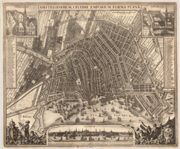
maps in the stadsarchief amsterdam
claes jansz. visscher (ii)
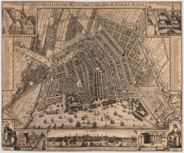
maps in the stadsarchief amsterdam
claes jansz. visscher (ii)
collection cartographic documents from het utrechts archief
18th-century maps of the netherlands
901 - 1000 of 1,210
Next page
/ 13