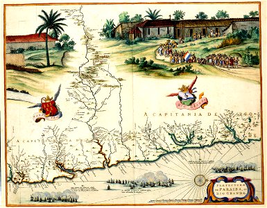
PRAEFECTURAE DE PARAIBA, ET RIO GRANDE, Joan Blaeu, 1662
Between 1630 and 1654 a large part of brazil was occupied by the dutch. In this period the area was surveyed and mapped by the cartographers cornelis goliath (deceased 1667/1668) and georg marcgraf. The results were compiled in a decorative wall map in 1643. Joan blaeu (1598-1673) used the wall map as his source for this map in 1662. Object Type: map. Date: 1662. Place of creation: Amsterdam. Dimensions: 42 x 54 cm. Medium: copper engraving print. Collection: Koninklijke Bibliotheek. Atlas Van der Hagen-KW1049B13 097-PRAEFECTURAE DE PARAIBA, ET RIO GRANDE
Author: Cornelis Golijath (1617–1660) Georg Marcgrave (1610–1644) Author: Cornelis Goliath en Georg Marcgraf Publisher: Joan Blaeu (1596–1673)Source: commons.wikimedia.org