Log in
All resources
Create a design
27,441 Free Images of Maps
bibliothèque nationale de france
maps of paris from bibliothèque nationale de france
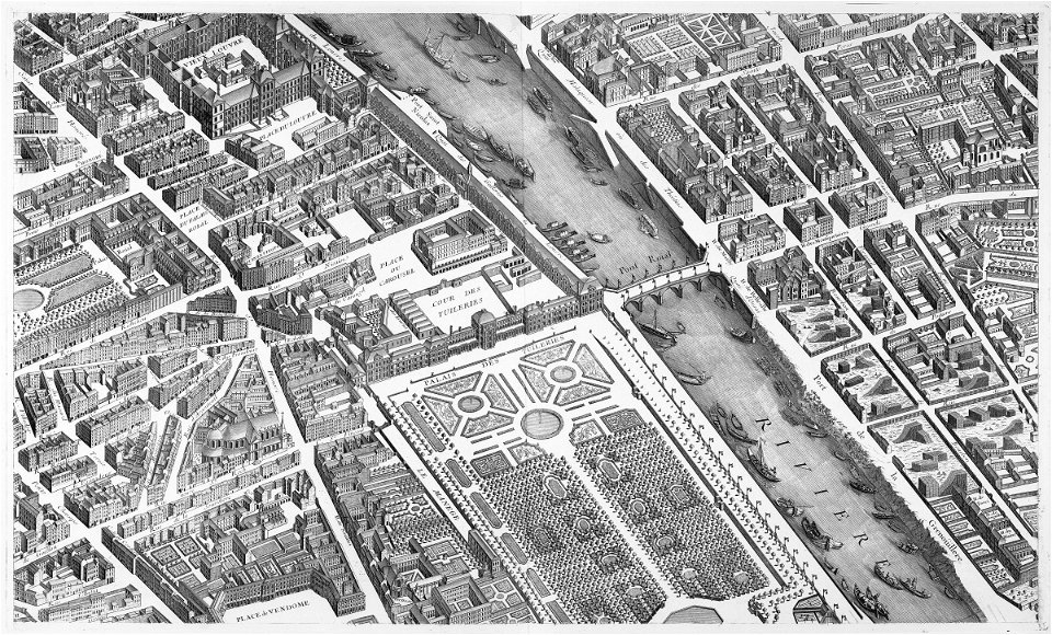
turgot map of paris, bibliothèque nationale de france
1667 maps
copper engraving print
british library
joan blaeu
gemeente atlas van nederland - south holland
1860s maps of south holland
1660s maps of spain
ordnance survey 1:25000 maps (full sheets)
maps of linlithgow
turgot map of paris, kyoto university library
sheet 15 of the turgot map of paris
17th-century maps of aisne
17th-century maps of oise
1760s maps of ireland
1766 maps
old maps of pyrénées-orientales
1852 maps of france
old submaps of paris 5e arrondissement
porte saint-victor (paris)
eran laor cartographic collection
gustav freytag (cartographer)
carte de la mer mediterranée (1764) by roux
eran laor cartographic collection
maps from the earth and its inhabitants, vol. xii
africa in the 1890s
maps from the earth and its inhabitants, vol. xii
africa in the 1890s
maps from the earth and its inhabitants, vol. xii
africa in the 1890s
turgot map of paris, bibliothèque nationale de france
maps of paris from bibliothèque nationale de france
turgot map of paris, bibliothèque nationale de france
maps of paris from bibliothèque nationale de france
turgot map of paris, bibliothèque nationale de france
maps of paris from bibliothèque nationale de france
turgot map of paris, bibliothèque nationale de france
maps of paris from bibliothèque nationale de france
turgot map of paris, bibliothèque nationale de france
maps of paris from bibliothèque nationale de france
turgot map of paris, bibliothèque nationale de france
maps of paris from bibliothèque nationale de france
turgot map of paris, bibliothèque nationale de france
maps of paris from bibliothèque nationale de france
turgot map of paris, bibliothèque nationale de france
maps of paris from bibliothèque nationale de france
turgot map of paris, bibliothèque nationale de france
maps of paris from bibliothèque nationale de france
19th-century maps of oxfordshire
bodleian maps collection
turgot map of paris, bibliothèque nationale de france
maps of paris from bibliothèque nationale de france
turgot map of paris, bibliothèque nationale de france
maps of paris from bibliothèque nationale de france
turgot map of paris, bibliothèque nationale de france
maps of paris from bibliothèque nationale de france
turgot map of paris, bibliothèque nationale de france
maps of paris from bibliothèque nationale de france
turgot map of paris, bibliothèque nationale de france
maps of paris from bibliothèque nationale de france
turgot map of paris, bibliothèque nationale de france
maps of paris from bibliothèque nationale de france
turgot map of paris, bibliothèque nationale de france
maps of paris from bibliothèque nationale de france
turgot map of paris, bibliothèque nationale de france
maps of paris from bibliothèque nationale de france
turgot map of paris, bibliothèque nationale de france
maps of paris from bibliothèque nationale de france
turgot map of paris, bibliothèque nationale de france
maps of paris from bibliothèque nationale de france
turgot map of paris, bibliothèque nationale de france
maps of paris from bibliothèque nationale de france
mississippian sites
plaquemine culture
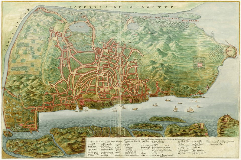
maps of goa by linschoten
goa (island)
maps in the library of congress
1882 maps of new york (state)
guide joanne espagne et portugal-1906
french-language maps
guide joanne espagne et portugal-1915
1915 maps
maps in the staats- und universitätsbibliothek hamburg
maps of hamburg-altstadt
gemeente atlas van nederland - south holland
1860s maps of south holland
national museum of maps and rare books, bucharest
maps of the lower danube
maps of the roman catholic diocese of liège
maps made in the 17th century
atlas des anciens plans de paris by imprimerie nationale, 1880 from the musée carnavalet
maps of paris from paris musées
maps of paris from the university of wisconsin-milwaukee libraries
18th-century maps of paris
maps of the yucatan peninsula
1801 maps of north america
gemeente atlas van nederland - north holland
19th-century maps of amsterdam
confluence of the seine and marne rivers
plan de roussel - derivative files
1660s maps of spain
1667 maps
1660s maps of spain
1667 maps
1660s maps of spain
1667 maps
1660s maps of spain
1667 maps
1660s maps of spain
1667 maps
atlas maior, vol 11 (asia) - joan blaeu, 1667 - bl 114.h(star).11
1667 maps
tresor des cartes geographiques (1659)
old maps of the benelux
map of the circle of austria by sanson
1680s maps of austria
map of the circle of austria by sanson
1670s maps of austria
maps made in the 17th century
old maps of lindau (bodensee)
führer durch dalmatien (1899)
old maps of dalmatia
17th-century maps of bremen (state)
1600s maps of lower saxony
old maps of hugli-chuchura
chinsurah
files based of data provided by the czech office for surveying and cadastre
svatý mikuláš (kutná hora district)
maps by willem and johannes blaeu
1650s maps of palestine
alphonsus lasor a varea
maps by jodocus hondius
17th-century maps of southeast asia
maps by jodocus hondius
maps by nicolas sanson
1730s maps of france
1851 maps of europe
edward lear
ptolemy's 7th european map
bologna ptolemy
old maps of pyrénées-orientales
coats of arms of perpignan
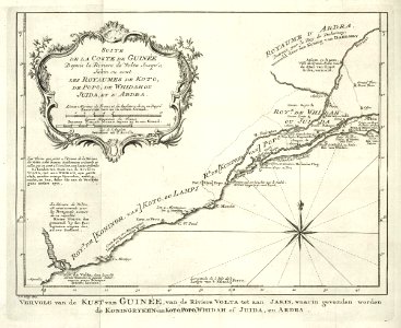
maps of the west-indische compagnie
1747 maps of africa
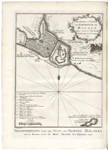
old maps of the dutch east india company - malaysia
1753 maps
hudson river school,impressionism,realism,realism
american paintings in the cincinnati art museum
french-language maps of turkey
1788 maps of turkey
old maps of kea (cyclades)
description de l'universe
maps in the national archives of sweden
erik dahlbergh
1670 maps of europe
hugo allardt
maps by louis brion de la tour
french-language maps of europe
old maps of bermuda from the norman b. leventhal map center
1639 maps
17th-century maps of central america
description de l'universe
henricus hondius ii, nova totius terrarum orbis geographica ac hydrographica tabula, 1630
eran laor cartographic collection
hendrik de leth
1737 maps
gemeente atlas van nederland - south holland
1860s maps of south holland
gemeente atlas van nederland - south holland
maps of heerjansdam
gemeente atlas van nederland - south holland
1860s maps of south holland
gemeente atlas van nederland - south holland
1860s maps of south holland
18th-century celestial maps
maps by matthäus seutter
maps by john cary
1801 maps
maps from géographie illustrée de la france et de ses colonies
orientalist painting
17th-century maps of europe
latin-language maps
1780s maps of portugal
maps by tomas lopez
18th-century maps of the azores
1780s maps of portugal
maps of spain by tomas lopez
1779 maps of spain
1770s maps of portugal
1770 maps of spain
maps of spain by tomas lopez
old maps of lanzarote
maps of orléans by braun & hogenberg
1682 maps of france
david rumsey historical map collection
17th-century maps of iceland
william hole (engraver)
michael drayton
maps from the earth and its inhabitants, vol. x
1890 maps of africa
english county maps by john ogilby
old county maps of middlesex
tower of babel in engravings
maps by nicolaes visscher i
17th-century maps of the black sea
description de l'universe
17th-century maps of the black sea
description de l'universe
3201 - 3300 of 27,441
Next page
/ 275