Map of Malacca, Jakob van der Schley, 1753

Map of Malacca, Jakob van der Schley, 1753

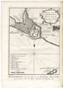
Map of malacca. Grondtékening van de stad en vesting malakka om te dienen voor de hist. Beschr. Der reizen, 1750. Plan de la ville et forteresse de malaca pour servir à l'histoire générale des voyages. 1750. Key: a-i. Bottom right: isle où les hollandois firent un batterie: / eiland waarop de hollanders een battery maakten. / i. Das naos, / suivant les portugais / auj. I. De java. Date: 1753. Dimensions: height: 13 cm (5.1 in); width: 18 cm (7 in). Medium: engraving on paper. Collection: Koninklijke Bibliotheek. AMH-7981-KB Map of Malacca
Edit image
Published by:
Creazilla
Author: Pieter de HondtSource: commons.wikimedia.org

Loading...

0 downloads
Loading...
old maps of the dutch east india company - malaysia1753 mapsmaps of melakamaps by jakob van der schleyengraving on paperkoninklijke bibliotheekjakob van der schley

MORE LIKE THIS

Creazilla logo
Over 10 million free graphic resources for content creators and designers.
© 2018 - 2025 Creazilla
Our resourcesAll imagesPhotosDigital illustrationsClipartIconsPNG ImagesEmojisSilhouettesTraditional Art3D ModelsVectorsFontsColor namesColor palettesGradientsAudioAnimationVideosTemplates
InformationAbout CreazillaTerms of useTech teamPrivacy policyLicence Information
FeedbackContact Us