Log in
All resources
Create a design
27,441 Free Images of Maps
eran laor cartographic collection
latin-language maps
frans hogenberg
bibliothèque nationale de france
baroque
gemeente atlas van nederland - zeeland
palatinatus rheni (merian)
maps of polders in zeeland
ateliers bmb mercator
old maps of sluis
1810s maps of portugal
maps by tomas lopez
18th-century maps of hispaniola
maps by juan lopez
17th-century maps of xaintonge
maps by jodocus hondius
maps by pieter mortier
maps from gallica
maps of mexico by mercator-hondius
portrait paintings of wilhelmine of bayreuth
juda pinhas
map of amsterdam, 1544
stadsarchief amsterdam
lucas janszoon waghenaer
1580s maps of spain
lucas janszoon waghenaer
maps facing east
1750s maps of california
1705 maps of california
maps in the library of congress
1744 maps
maps of territories in the burgundian circle
1645 maps of belgium
joan blaeu
1648 maps
ptolemy's 4th european map
maps by girolamo porro
old maps of towns in england
arundel castle in art
old maps of southeast asia
maps by gerard valck
maps by jan janssonius
atlas novus (blaeu)
maps of gdańsk by braun & hogenberg
eran laor cartographic collection
maps from the earth and its inhabitants, vol. xi
algeria in the 1800s
maps of avignon by braun & hogenberg
eran laor cartographic collection
maps of antwerp by braun & hogenberg
eran laor cartographic collection
maps of alexandria by braun & hogenberg
eran laor cartographic collection
maps of bruges by braun & hogenberg
eran laor cartographic collection
siberia and the exile system (1891)
maps of zabaykalsky krai
maps from the earth and its inhabitants, vol. xiii
africa in the 1890s
maps of granada by braun & hogenberg
eran laor cartographic collection
maps of basel by braun & hogenberg
eran laor cartographic collection
maps of cambridge by braun & hogenberg
eran laor cartographic collection
maps of emden by braun & hogenberg
eran laor cartographic collection
vltava flood 1890 in prague
old maps of prague
maps of brussels by braun & hogenberg
eran laor cartographic collection
maps of ancona by braun & hogenberg
eran laor cartographic collection
maps of damascus by braun & hogenberg
eran laor cartographic collection
eran laor cartographic collection
maps of huy by braun & hogenberg
maps of antequera by braun & hogenberg
eran laor cartographic collection
maps of groningen by braun & hogenberg
eran laor cartographic collection
maps from the earth and its inhabitants, vol. xii
africa in the 1890s
maps of ghent by braun & hogenberg
eran laor cartographic collection
maps of haarlem by braun & hogenberg
eran laor cartographic collection
maps of gouda by braun & hogenberg
eran laor cartographic collection
maps of blois by braun & hogenberg
eran laor cartographic collection
maps of amsterdam by braun & hogenberg
eran laor cartographic collection
maps from the mechanical curator collection available to georeference
maps from the mechanical curator collection
topographia austriacarum (merian)
baroque
maps of aachen by braun & hogenberg
eran laor cartographic collection
maps from the earth and its inhabitants, vol. xi
algeria in the 1800s
palatinatus rheni (merian)
baroque
catalan atlas, 1959 reproduction
coats of arms on maps
gemeente atlas van nederland - north holland
blokker
palatinatus rheni (merian)
baroque
maps of polders in zeeland
old maps of sluis
historical images of la crosse, wisconsin
maps in the library of congress
palatinatus rheni (merian)
baroque
palatinatus rheni (merian)
baroque
palatinatus rheni (merian)
baroque
maps of tournai city walls
old maps of tournai
maps of polders in zeeland
old maps of sluis
old maps of zwolle
atlas van loon
gemeente atlas van nederland - north brabant
maps of putte, netherlands
maps of polders in zeeland
old maps of sluis
gemeente atlas van nederland - zeeland
maps of westkapelle (walcheren)
maps of polders in zeeland
old maps of sluis
maps of polders in zeeland
maps of terneuzen
narrative of the defence of kars, historical and military (1857) by lake
maps from the mechanical curator collection
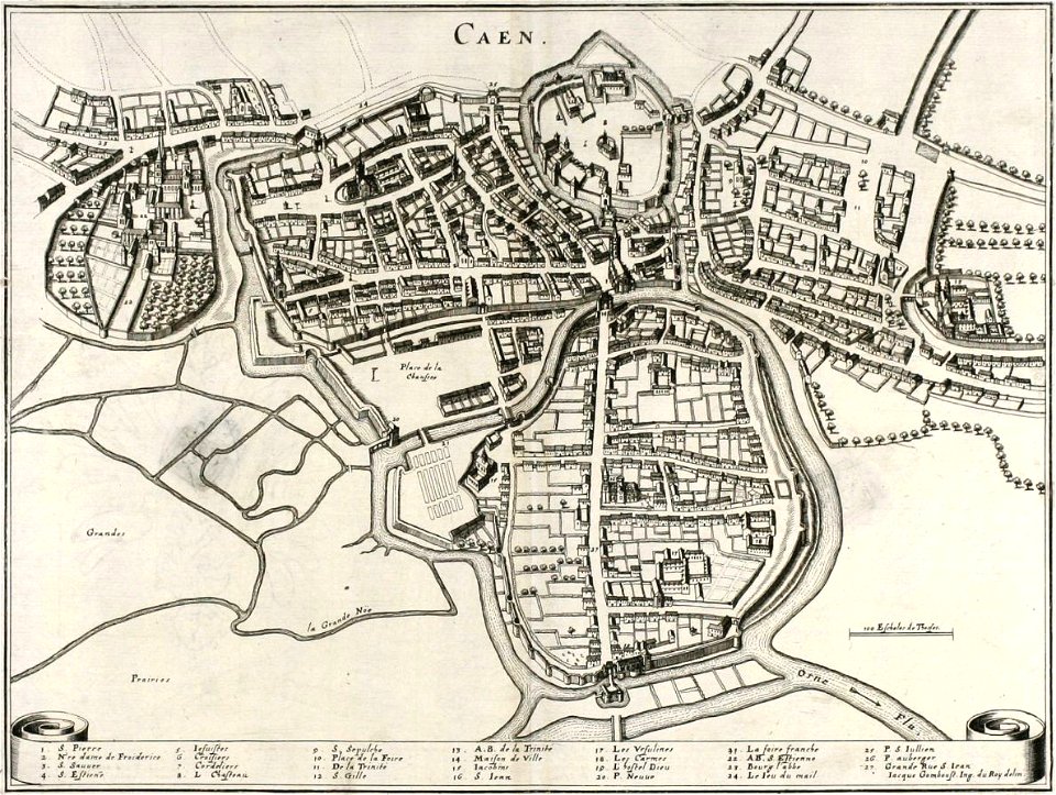
old maps of caen
baroque
old maps of gelderland
atlas van loon
maps of liège by johannes blaeu - derivative files
outremeuse
map of paris by braun & hogenberg - derivative files
rue de braque on maps
bibliothèque municipale de reims, rès. g 152
1656 maps of france
maps in the rijksmuseum amsterdam
1627 maps
old maps of the environments of paris
maps by alexis-hubert jaillot
maps of bernkastel-kues by braun & hogenberg
maps of zell (mosel) by braun & hogenberg
map of ancient armenia by philippe de la rué
eran laor cartographic collection
atlas vingboons
1665
geographia universalis (1545) in the british museum
german renaissance,northern renaissance
geographia universalis (1545) in the british museum
german renaissance,northern renaissance
maps by willem and johannes blaeu
17th-century maps of bermuda
old maps of the northern hemisphere
1800s maps of the world
maps of iceland by gerardus mercator
ateliers bmb mercator
maps of europe by mercator-hondius
ateliers bmb mercator
maps of south scotland by gerardus mercator
ateliers bmb mercator
maps of africa by rumold mercator
ateliers bmb mercator
maps of asia by gerardus mercator
ateliers bmb mercator
maps of the greek colonies
old maps of ancient greece
media from accademia delle scienze di torino
1573 maps of italy
biblioteca di storia e cultura del piemonte "giuseppe grosso"
media from giuseppe grosso library
coats of arms on maps
atlas novus (blaeu)
our arctic province, alaska and the seal islands (1886)
old maps of alaska
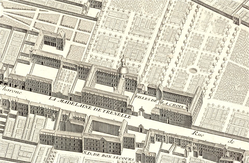
turgot map of paris, david rumsey historical map collection – derivative files
palais de la femme
curt teich postcard archives
map postcards
turgot map of paris, david rumsey historical map collection – derivative files
port de la rapée
maps related to akseli gallen-kallela in kenya
romanticism,symbolism,romantic nationalism
eran laor cartographic collection
joris hoefnagel
maps in the library of congress
old city hall (knoxville)
media from regionaal archief alkmaar
zuidschermer
maps by willem and johannes blaeu
1635 maps
neoclassicism
1762 maps
herman diederik joan van schevichaven
revolt of the batavi
maps of africa in the robert c. williams paper museum
1665 maps of africa
herman diederik joan van schevichaven
maps of the history of belgium
7601 - 7700 of 27,441
Next page
/ 275