Log in
All resources
Create a design
27,441 Free Images of Maps
david rumsey historical map collection
bibliothèque nationale de france
engraving on paper
maps of paris from the david rumsey historical map collection
atlas des anciens plans de paris by imprimerie nationale, 1900 from the david rumsey historical map collection
18th-century maps of paris
atlas map
maps by jakob van der schley
koninklijke bibliotheek
jakob van der schley
jodocus hondius ii, nova totius terrarum orbis geographica ac hydrographica tabula, 1636
eran laor cartographic collection
maps by thomas kitchin
andrew dury
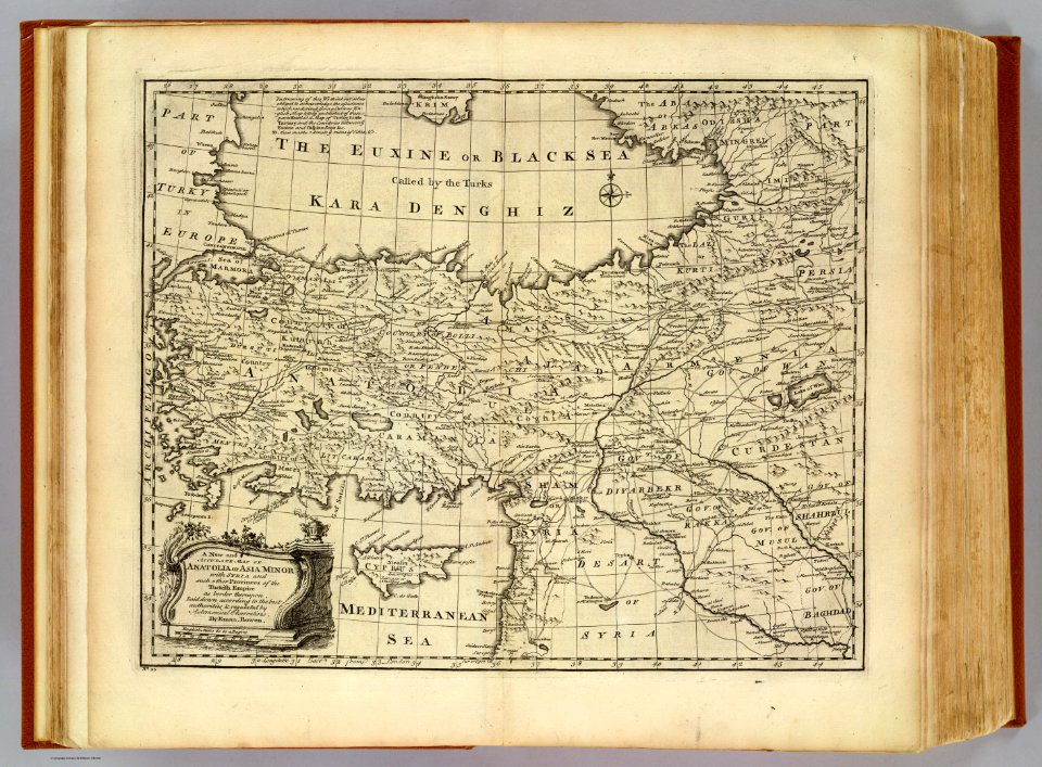
17th-century maps of the middle east
description de l'universe
19th-century maps of vietnam
1810s maps of china
old maps of gorinchem
1730 maps
maps from the earth and its inhabitants, vol. vi
georgia in the 1890s
maps of the dutch east india company - indonesia
18th-century maps of java
atlas des anciens plans de paris by imprimerie nationale, 1900 from the david rumsey historical map collection
maps of paris from the david rumsey historical map collection
atlas des anciens plans de paris by imprimerie nationale, 1900 from the david rumsey historical map collection
maps of paris from the david rumsey historical map collection
atlas des anciens plans de paris by imprimerie nationale, 1900 from the david rumsey historical map collection
maps of paris from the david rumsey historical map collection
atlas des anciens plans de paris by imprimerie nationale, 1900 from the david rumsey historical map collection
maps of paris from the david rumsey historical map collection
atlas des anciens plans de paris by imprimerie nationale, 1900 from the david rumsey historical map collection
maps of paris from the david rumsey historical map collection
atlas des anciens plans de paris by imprimerie nationale, 1900 from the david rumsey historical map collection
maps of paris from the david rumsey historical map collection
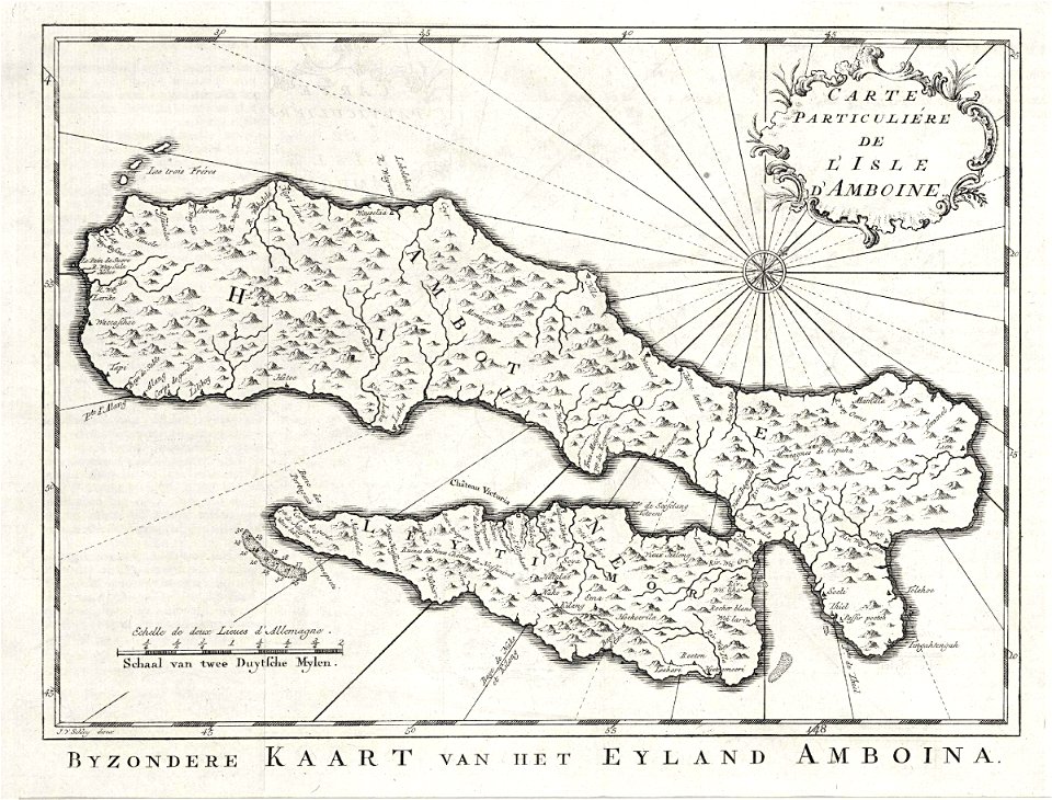
maps of the dutch east india company - indonesia
old maps of ambon
historical map collection
maps by emanuel bowen
17th-century maps of the mediterranean sea
guillaume sanson
daniel de la feuille
johannes ratelband
old maps of the republic of genoa
maps of the duchy of milan
1680s maps of france
valois (ducato)
map of the circle of the rhineland by sanson
maps by nicolas sanson
beschreibung der städt der welt - braun & hogenberg - btv1b52512111k
maps of weimar by braun & hogenberg
beschreibung der städt der welt - braun & hogenberg - btv1b52512111k
maps of tangier by braun & hogenberg
historisk atlas (stockholm, norstedt & söner, 1880)
old maps of the polish-lithuanian commonwealth
1640s maps of north rhine-westphalia
history of cologne
17th-century maps of trinidad and tobago
animals on maps
maps of aire-sur-la-lys city walls
old maps of aire-sur-la-lys
1830 maps of pennsylvania
battle of brandywine
maps of neuss by braun & hogenberg
eran laor cartographic collection
18th-century maps of the sea of marmara
18th-century maps of the dardanelles
maps of valenciennes by braun & hogenberg
maps of valenciennes city walls
maps of ancient israel by philippe de la rué
map of modern syria by philippe de la rué
1600s maps of north america
1600s maps of south america
maps by alain manesson-mallet
1719 maps of africa
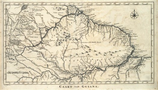
maps of the ganges river
old maps of bengal
19th-century maps of vaucluse
1852 maps of france
maps of ven (oresund)
old maps of skåne
old maps of the falkland islands
1901 maps of south america
1610s maps of the netherlands
old maps of friesland
18th-century maps of catalonia
daniel de la feuille
svg maps of the world centered 10e
svg maps with robinson projection
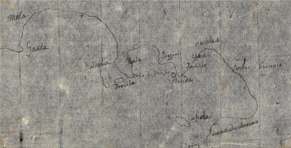
drawings by john robert cozens in the yale center for british art
naples by john robert cozens
maps with cartouches
old maps of yunnan
19th-century maps of chechnya
1880s maps of the caucasus
maps by willem and johannes blaeu
maps of delfshaven
cornelis de jode
1578 maps
maps from traité de la police, bibliothèque nationale de france
third map of paris from traité de la police
maps in the library of congress
old maps of barbados
gemeente atlas van nederland - groningen
maps of winschoten
maps of paris from bibliothèque nationale de france
nouveau plan de paris by louis brion de la tour
illustrated title pages
1645 books
old maps of the london borough of tower hamlets
maps by john pine
1640s maps of brazil
georg marggraf
18th-century maps of the indian ocean
18th-century maps of southeast asia
topographia alsatiae (merian)
baroque
maps of the dutch east india company - thailand
old maps of the dutch east india company
monomotapa
mutapa
roman catholic archdiocese of salzburg
old maps of salzburg (state)
maps of mecklenburg-schwerin
old maps of mecklenburg
cornell: persuasive cartography: the pj mode collection
europe in the 1870s
maps of mons city walls (hainaut)
old maps of mons (hainaut)
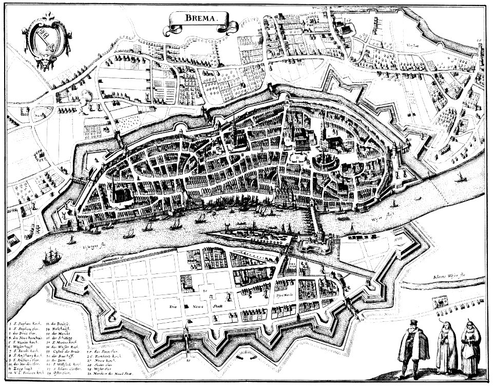
bremen in topographia saxoniae inferioris (merian)
baroque
maps in the library of congress
1870 cartoons
maps in the library of congress
novus atlas sinensis
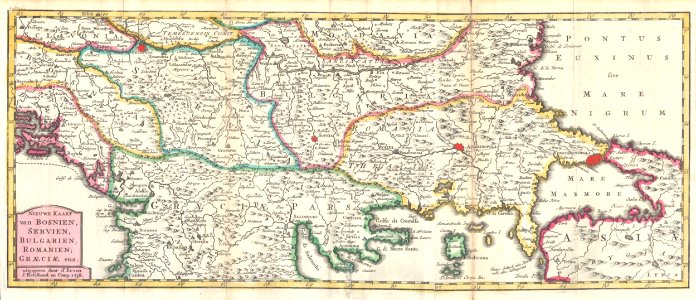
russian empire in thomas kitchen's general atlas (1773)
general atlas (1773)
highways and byways in cambridge and ely (book)
old maps of cambridge
maps of cambridge by braun & hogenberg
1575 maps of england
old county maps of gloucestershire
old county maps of monmouthshire
maps by jan eduard wagner
františek kytka
19th-century maps of bohemia
1880s maps of czechia
old county maps of leicestershire
old county maps of rutland
1665 maps of ukraine
1665 maps
maps by alexis-hubert jaillot
old maps of poland
1570s maps of the ottoman empire
1576 maps of europe
algeria in the 1880s
old maps of algeria
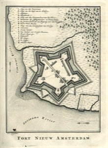
west-indische compagnie
1770 maps
turgot map of paris, kyoto university library – derivative files
palais du louvre on old maps
old maps of île-de-france
1785 maps of france
portrait of george washington by giuseppe perovani
1790s maps of washington, d.c.
19th-century maps of bohemia
maps of regions of bohemia
eran laor cartographic collection
edward weller
synopsis universae philologiae
1741 maps of europe
1640s maps of pernambuco
1647 maps of brazil
david rumsey historical map collection
andrew dury
maps of the moscow kremlin
baroque
1800s maps of london
1801 in london
old maps of latvia
maps of livonia
maps by willem and johannes blaeu
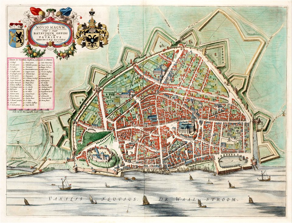
old maps of nijmegen
maps of the dutch east india company - iran
old maps of the dutch east india company
historical map collection
maps by john cary
maps of the west-indische compagnie
1770 maps
maps of fort worth, texas
maps by henry wellge
atlas des anciens plans de paris by imprimerie nationale, 1900 from the david rumsey historical map collection
maps of paris from the david rumsey historical map collection
images in ottův slovník naučný (volume 6)
maps in ottův slovník naučný
map of rome by giovanni battista falda (1676)
maps in the rijksmuseum amsterdam
collections of the national library of israel
louis-joseph mondhare
delle navigationi et viaggi
italian-language maps
1740s maps of the caucasus
maps by emanuel bowen
road maps of the united kingdom
bodleian maps collection
maps from the mechanical curator collection available to georeference
maps from the mechanical curator collection
mississippian sites
plaquemine culture
1801 - 1900 of 27,441
Next page
/ 275