Log in
All resources
Create a design
26,489 Free Artworks of Map
maps in the library of congress
bibliothèque nationale de france
maps by gerard valck
municipal library of trento
gerard valck
baroque
coats of arms on maps
maps by john cary
john cary
maps by pieter schenk (i)
zehn karten und ansichten den schlachtfelden des amerikanischen unabhängigkeitskreiges in den staaten pennsylvanien und new york
maps in the library of congress
17th-century maps of africa
maps from gallica
zehn karten und ansichten den schlachtfelden des amerikanischen unabhängigkeitskreiges in den staaten pennsylvanien und new york
maps in the library of congress
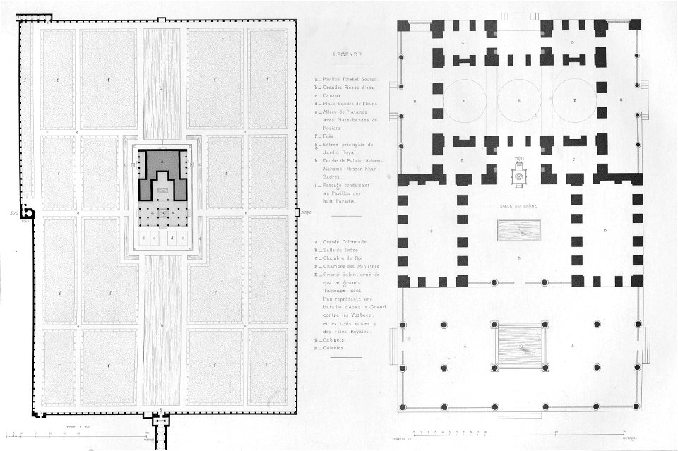
pascal coste
chehel sotun
maps of paris from the david rumsey historical map collection
1774 in paris
works after polidoro da caravaggio
maps in the british museum
maps by john cary
1799 maps
1800s maps of denmark
1801 maps of europe
demolished churches in de barbari map
sant'antonio abate (venice)
avenionensis ditio et venaisinus comitatus (galleria delle carte geografiche)
paintings in the musée de la marine de toulon
émile vernet-lecomte
très riches heures du duc de berry
early netherlandish painting
sheets of stamps of russia, 1997
moscow on stamps
drawings in the museu antônio parreiras
paper and graphite
17th-century maps of france
history of perche
eran laor cartographic collection
afbeeldinge der stad jerusalem
maps made in the 17th century
berry (ducato)
maps of the malay archipelago by mercator-hondius
maps of hamburg-bahrenfeld
maps of altona
1779 maps of the united states
1770s maps of the caribbean
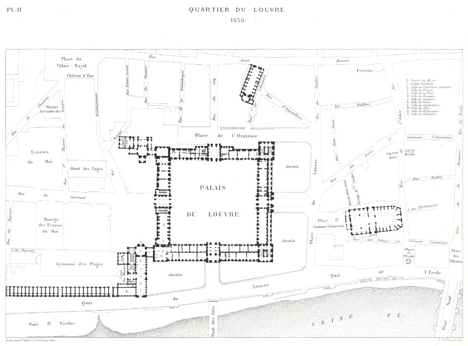
engravings of louvre by theodor hoffbauer
lithographs of paris
maps of bremen
maps of weser
old maps of japan
kimura kenkado
asia noviter delineata
java in art
too late for gordon and khartoum (1887) by macdonald
old maps of the nile
maps from university of amsterdam special collections
atlas der neederlanden
maps from university of amsterdam special collections
atlas der neederlanden
praefectura paranambucae pars borealis, una cum praefectura de itâmaracâ
1690s maps of pernambuco
the cruise of the alice may in the gulf of st. lawrence and adjacent waters (1885) by benjamin
maps from the mechanical curator collection
maps related to akseli gallen-kallela in kenya
romanticism,symbolism,romantic nationalism
old geological maps by jean-etienne guettard
jean étienne guettard
atlas schoemaker-noord-holland, amsterdam
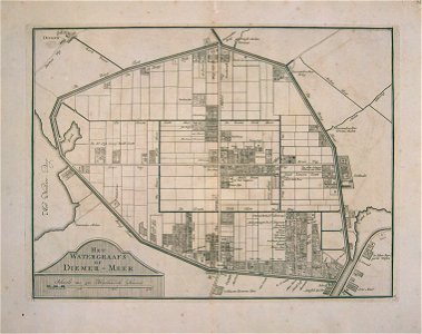
old maps of diemen
atlas schoemaker-noord-holland, amsterdam
old maps of amsterdam
maps by john cary
1799 maps
maps of the course of the rhine by guillaume sanson
guillaume sanson
coats of arms of cities in lot-et-garonne
victor levasseur - maps of france
maps from the earth and its inhabitants, vol. xii
maps of africa
flemish 18th-century prints in the rijksmuseum amsterdam
maps of ghent by e.h. fricx
historisk atlas (stockholm, norstedt & söner, 1880)
maps of the history of asia
gemeente atlas van nederland - south holland
1860s maps of south holland
gemeente atlas van nederland - north holland
old maps of heemstede, north holland
maps from the earth and its inhabitants, vol. x
maps of ancient nubia
maps by willem and johannes blaeu
old maps of delft
engravings of topographia superioris saxoniae, thüringiae, misniae et lusatiae (merian)
baroque
locator maps of the harbour of rotterdam
zalmhaven (rotterdam)
maps of the roman catholic diocese of liège
maps made in the 17th century
navigantium atque itinerantium bibliotheca
1764 fleurons
high renaissance
codex windsor
1594 in aschaffenburg
1594 maps of bavaria
ancien château de wasselonne
baroque
maps from the earth and its inhabitants, vol. xiii
africa in the 1890s
maps in the library of congress
1857 maps of pennsylvania
la rioja (spain) in the 18th century
old maps of la rioja (spain)
17th-century maps of the netherlands
maps of the wadden sea
map of the upper rhenian circle by sanson
maps by nicolas sanson
17th-century maps of crete
old maps of candia
landais & oberthur
maps from gallica
maps in the british museum
old maps of leeds
lucas janszoon waghenaer
1584 maps of norway
atlas van loon
maps of sieges
old maps of rio grande do norte
old maps of paraíba
maps of europe by mercator-hondius
jodocus hondius i
1600 world map by girolamo porro
leonardo cernoti
1600 world map by girolamo porro
leonardo cernoti
maps of ghent by i. tirion
isaak tirion
paulownia tomentosa (cultivated in north america)
nrcs new york (state) distribution maps
typus orbis terrarum
1570 maps
eran laor cartographic collection
clara filleul
old maps of arnemuiden
atlas van loon
candia in the 17th century
baroque
eran laor cartographic collection
edward weller
maps by thomas kitchin
1770 maps of africa
austro-hungarian north pole expedition
maps of franz joseph land
old maps of georgia (u.s. state)
maps in the library of congress
gemeente atlas van nederland - south holland
maps of koudekerk aan den rijn
maps from the earth and its inhabitants, vol. xii
canary islands in the 1890s
maps from géographie illustrée de la france et de ses colonies
19th-century maps of alpes-maritimes
maps from the earth and its inhabitants, vol. xii
canary islands in the 1890s
victor levasseur - maps of france
coats of arms of perpignan
theatre geographique du royaume de france (1632)
maps of perigord
coats of arms of cities in var
19th-century maps of var
maps of brussels city walls
old maps of brussels
theatri praecipvarvm totivs mvndi vrbivm : liber sextvs (1618)
maps of york by braun & hogenberg
maps of paris by braun & hogenberg
georg braun
old maps of the dutch east india company - africa
1665
old north knoxville historic district
maps in the library of congress
theatri praecipvarvm totivs mvndi vrbivm : liber sextvs (1618)
maps of heilbronn by braun & hogenberg
maps in the library of congress
1773 maps of the united states
grenzkarte der preussischen, russischen und oestreichischen monarchien (1796)
maps of kovno governorate
maps of wissembourg by braun & hogenberg
maps of colmar by braun & hogenberg
maps in the library of congress
1771 maps of north america
maps in the library of congress
cartes et plans de l'amerique
media from regionaal archief alkmaar
maps of texel
prints by johan teyler in the rijksmuseum amsterdam
albums in the rijksmuseum amsterdam
demolished churches in de barbari map
san domenego (venice)
coats of arms of erbach family
coats of arms on maps
topographia westphaliae (merian)
baroque
historical images of rapperswil-jona
topographischer atlas der schweiz
cross of trier in heraldry
coats of arms on maps
maps by willem and johannes blaeu
old maps of wageningen
5201 - 5300 of 26,489
Next page
/ 265