Log in
All resources
Create a design
26,489 Free Artworks of Map
maps from the earth and its inhabitants, vol. x
1890 maps of africa
19th-century maps of east africa
beschreibung und contrafactur der vornembster stät der welt, liber primus civitates orbis terrarum
bibliothèque nationale de france
eran laor cartographic collection
map - museu antônio parreiras
antônio parreiras
description de l'universe
alain manesson mallet
travels in the interior of north america, during the years 1832–1834
works by maximilian zu wied-neuwied
illustrations by true williams
roughing it (1872)
old maps of the dutch east india company
1705
maps of the west-indische compagnie
1705
carte de la mer mediterranée (1764) by roux
eran laor cartographic collection
brazilian paintings in the museu antônio parreiras
textile and oil painting on canvas
17th-century maps of mecklenburg-vorpommern
johann lauremberg
drawings in the museu antônio parreiras
paper and india ink
maps in the library of congress
old maps of connecticut
1572 maps of africa
1570s maps of egypt
19th-century maps of antwerp
maps of antwerp city walls
eran laor cartographic collection
willem blaeu
old maps of the county of ravensberg
burg limberg
maps by wilhelm maximilian carpelan
stockholmsvägen, lidingö
maps from the earth and its inhabitants, vol. x
1890 maps of africa
maps from the earth and its inhabitants, vol. xi
africa in the 1890s
maps of the history of sweden
old maps of scandinavia
fort rammekens in art
old maps of zeeland
maps from the earth and its inhabitants, vol. x
1890 maps of africa
maps by christian sgrothen
old maps of north holland
maps from the earth and its inhabitants, vol. x
1890 maps of africa
maps from the earth and its inhabitants, vol. x
1890 maps of africa
maps from the earth and its inhabitants, vol. x
1890 maps of africa
maps from the earth and its inhabitants, vol. x
1890 maps of africa
maps from the earth and its inhabitants, vol. x
1890 maps of africa
maps from the earth and its inhabitants, vol. x
1890 maps of africa
maps from the earth and its inhabitants, vol. x
1890 maps of africa
maps from the earth and its inhabitants, vol. x
1890 maps of africa
maps from the earth and its inhabitants, vol. x
1890 maps of africa
maps from the earth and its inhabitants, vol. x
1890 maps of africa
maps from the earth and its inhabitants, vol. x
1890s maps of egypt
maps from the earth and its inhabitants, vol. x
1890 maps of africa
maps from the earth and its inhabitants, vol. x
1890 maps of africa
maps from the earth and its inhabitants, vol. x
1890 maps of africa
maps from the earth and its inhabitants, vol. x
1890 maps of africa
details of old maps of amsterdam
map of amsterdam, 1625
maps from the earth and its inhabitants, vol. xi
africa in the 1890s
maps by willem and johannes blaeu
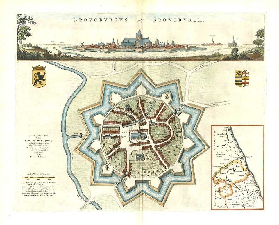
old maps of bourbourg
thomas onwhyn
cartoons
topographia braunschweig lüneburg (merian)
baroque
maps of bamberg by braun & hogenberg
gangulphus
maps by willem and johannes blaeu
old maps of zutphen
maps by wilhelm maximilian carpelan
lidingöbro värdshus
19th-century maps of stockholm
prins eugens waldemarsudde
midden-delfland in the 18th century
maps of midden-delfland
maps of london by braun & hogenberg
eran laor cartographic collection
middle ages in greece
maps of corfu town
maps of santander by braun & hogenberg
eran laor cartographic collection
eran laor cartographic collection
maps of lyon by braun & hogenberg
description de l'universe
1683 maps of europe
description de l'universe
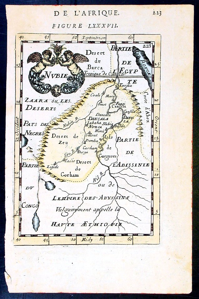
maps of nubia
maps of the deccan sultanates
description de l'universe
description de l'universe
maps of nubia
sanborn maps of manhattan published in 1904
irt sixth avenue line stations
19th-century portrait paintings in the musée national du château de versailles
jean-baptiste mauzaisse
catalan atlas
map of ghent by lucas de heere
lucas de heere
maps of paris by braun & hogenberg
maps of paris from paris musées
gemeente atlas van nederland - overijssel
netherlands in the 1860s
parts of old maps of berlin
maps of berlin-mitte
maps of aire-sur-la-lys city walls
old maps of aire-sur-la-lys
gemeente atlas van nederland - friesland
old maps of leeuwarden
merian plan of paris
baroque
paintings by antônio parreiras in the museu antônio parreiras
paintings of cityscapes by antônio parreiras
inspection générale des carrières
maps from gallica
paintings by antônio parreiras in the museu antônio parreiras
portrait paintings by antônio parreiras
beschreibung und contrafactur der vornembster stät der welt, liber primus civitates orbis terrarum
maps of parma by braun & hogenberg
beschreibung und contrafactur der vornembster stät der welt, liber primus civitates orbis terrarum
maps of weimar by braun & hogenberg
beschreibung und contrafactur der vornembster stät der welt, liber primus civitates orbis terrarum
maps of hormuz by braun & hogenberg
beschreibung und contrafactur der vornembster stät der welt, liber primus civitates orbis terrarum
maps of salzburg by braun & hogenberg
hamburgische elbkarte von melchior lorichs
parts of old maps of hamburg
people with maps in art
maurice langaskens
tresor des cartes geographiques (1659)
17th-century maps of silesia
maps of alsace by guillaume sanson
robert cordier (engraver)
beschreibung und contrafactur der vornembster stät der welt, liber primus civitates orbis terrarum
maps of aden by braun & hogenberg
beschreibung und contrafactur der vornembster stät der welt, liber primus civitates orbis terrarum
maps of goa by braun & hogenberg
maps from the mechanical curator collection available to georeference
maps from the mechanical curator collection
beschreibung und contrafactur der vornembster stät der welt, liber primus civitates orbis terrarum
maps of munich by braun & hogenberg
beschreibung und contrafactur der vornembster stät der welt, liber primus civitates orbis terrarum
maps of worms by braun & hogenberg
beschreibung und contrafactur der vornembster stät der welt, liber primus civitates orbis terrarum
maps of bremen by braun & hogenberg
beschreibung und contrafactur der vornembster stät der welt, liber primus civitates orbis terrarum
maps of tangier by braun & hogenberg
maps of 's-hertogenbosch by braun & hogenberg
maps of leuven by braun & hogenberg
maps of north america, nypl collection
novi belgii, atlas maior
gemeente atlas van nederland - south holland
maps of den bommel
german renaissance
stabius world map
maps from the earth and its inhabitants, vol. xii
canary islands in the 1890s
viage á constantinopla, en el año de 1784 (1790)
18th-century maps of the sea of marmara
old maps in the bibliothèque nationale de france
old maps of the holy roman empire
gemeente atlas van nederland - south holland
maps of groote lindt
maps from the earth and its inhabitants, vol. x
1890s maps of the nile delta
civitates orbis terrarvm, liber primvs (1577)
maps of nuremberg by braun & hogenberg
maps of the dutch east india company - sri lanka
1750
civitates orbis terrarvm, liber primvs (1577)
maps of diu by braun & hogenberg
civitates orbis terrarvm, liber primvs (1577)
maps of braunschweig by braun & hogenberg
16th-century maps of baden-württemberg
hohenlohe-zentralarchiv neuenstein
old maps of toledo, spain
1580s maps of spain
johann friedrich walther
1738 in berlin-mitte
a voyage to abyssinia, and travels into the interior of that country, executed under the orders of the british government in the years 1809 & 1810
john outhett
zehn karten und ansichten den schlachtfelden des amerikanischen unabhängigkeitskreiges in den staaten pennsylvanien und new york
maps in the library of congress
zehn karten und ansichten den schlachtfelden des amerikanischen unabhängigkeitskreiges in den staaten pennsylvanien und new york
maps in the library of congress
5101 - 5200 of 26,489
Next page
/ 265