Log in
All resources
Create a design
115 Free Artworks of 1741 Maps
bibliothèque nationale de france
chorographia britanniae (1741-1742)
maps in the rijksmuseum amsterdam
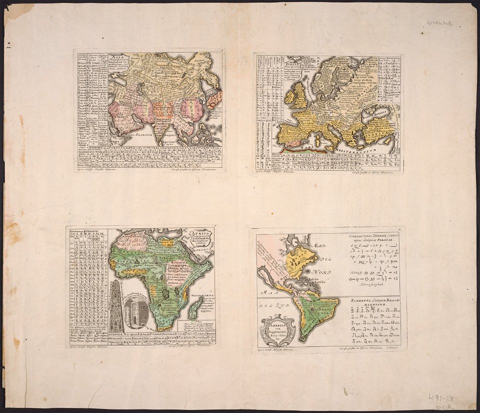
synopsis universae philologiae
1741 maps of asia
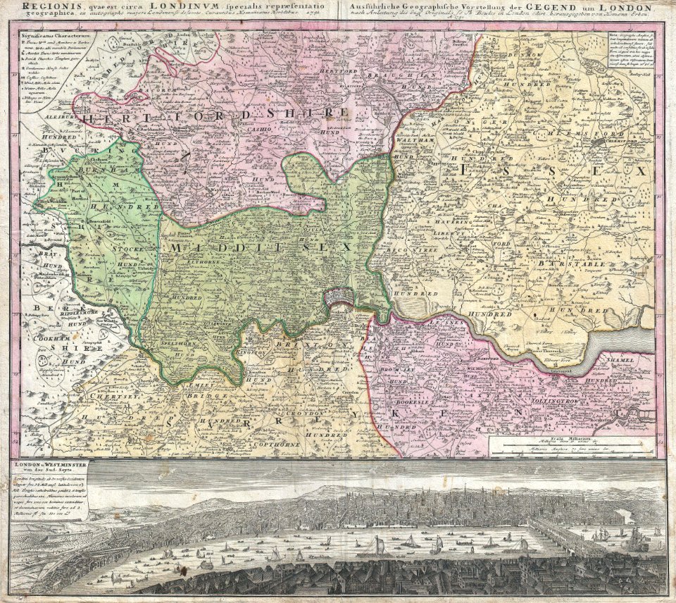
john rocque
1741 maps of europe
1741 maps of africa
john rocque's 1748 map of london and adjacent country
1740s maps of the americas
kaart van het baljuwschap kennemerland
maps in the rijksmuseum amsterdam
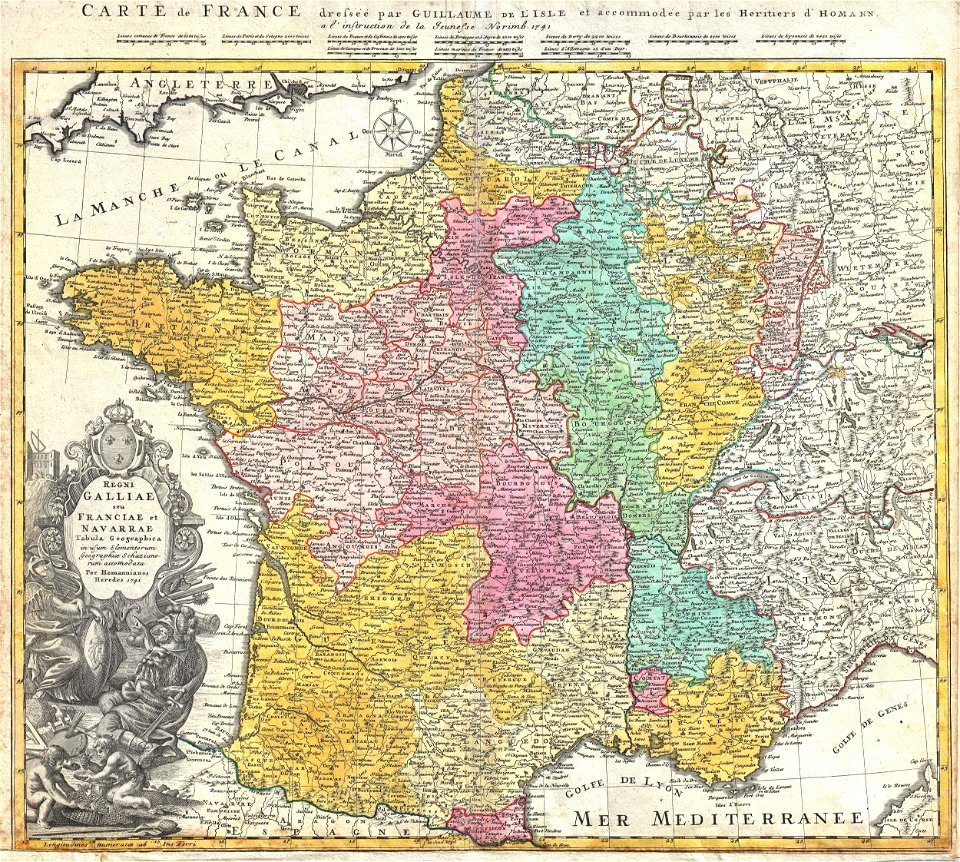
administrative history of france
johann baptist homann
18th-century maps of london
johann baptist homann
cornell: persuasive cartography: the pj mode collection
cornell university library
mdcclxxvi (numeral)
1776 maps
alphabet charts
lord's prayer
synopsis universae philologiae
maps of continents
1740s maps of the netherlands
maps of borculo
synopsis universae philologiae
1741 maps of europe
maps of lichtenvoorde
house of bronckhorst
old maps of bredevoort
maps by isaak tirion
synopsis universae philologiae
1740s maps of the world
synopsis universae philologiae
1741 maps of europe
synopsis universae philologiae
classicism
synopsis universae philologiae
1741 maps of asia
18th-century maps of the indian ocean
bodleian maps collection
old maps of atlantis
island of california
synopsis universae philologiae
1741 maps of europe
old maps of gelderland
isaak tirion
geneviève brossard de beaulieu
jean-françois de la pérouse
john rocque's 1746 map of london
history of london
old county maps of oxfordshire
bodleian maps collection
synopsis universae philologiae
1741 maps of asia
18th-century maps of england and wales
chorographia britanniae (1741-1742)
18th-century maps of england and wales
chorographia britanniae (1741-1742)
chorographia britanniae (1741-1742)
1740s maps of wales
chorographia britanniae (1741-1742)
1740s maps of wales
maps published by hendrik de leth
algiers in the 18th century
portrait paintings in the musée thomas-henry
male portraits by robert lefèvre
map of ancient armenia by philippe de la rué
maps of antony's parthian war
18th-century maps of england and wales
chorographia britanniae (1741-1742)
18th-century maps of antarctica
1741 maps
maps of texel
caspar specht
eran laor cartographic collection
isaak tirion
old maps of atlantis
island of california
18th-century maps of the indian ocean
guillaume dheulland
18th-century maps of england and wales
chorographia britanniae (1741-1742)
maps in the rijksmuseum amsterdam
maps by jakob van der schley
chorographia britanniae (1741-1742)
18th-century maps of kent
chorographia britanniae (1741-1742)
18th-century maps of cornwall
chorographia britanniae (1741-1742)
18th-century maps of essex
old maps of norway
guillaume sanson
old maps of norway
guillaume sanson
chorographia britanniae (1741-1742)
18th-century maps of sussex
18th-century maps of nottinghamshire
chorographia britanniae (1741-1742)
chorographia britanniae (1741-1742)
18th-century maps of cambridgeshire
chorographia britanniae (1741-1742)
18th-century maps of middlesex
chorographia britanniae (1741-1742)
18th-century maps of monmouthshire
chorographia britanniae (1741-1742)
18th-century maps of westmorland
18th-century maps of huntingdonshire
chorographia britanniae (1741-1742)
chorographia britanniae (1741-1742)
18th-century maps of northumberland
chorographia britanniae (1741-1742)
18th-century maps of cumberland
maps in the rijksmuseum amsterdam
johannes ratelband
1770s portrait paintings from austria (male)
johann georg weikert
chorographia britanniae (1741-1742)
18th-century maps of hampshire
chorographia britanniae (1741-1742)
18th-century maps of hertfordshire
chorographia britanniae (1741-1742)
18th-century maps of surrey
chorographia britanniae (1741-1742)
18th-century maps of staffordshire
chorographia britanniae (1741-1742)
18th-century maps of leicestershire
chorographia britanniae (1741-1742)
18th-century maps of devon
chorographia britanniae (1741-1742)
18th-century maps of rutland
chorographia britanniae (1741-1742)
18th-century maps of worcestershire
chorographia britanniae (1741-1742)
18th-century maps of cheshire
18th-century maps of norfolk, england
chorographia britanniae (1741-1742)
18th-century maps of herefordshire
old county maps of herefordshire
chorographia britanniae (1741-1742)
18th-century maps of suffolk
chorographia britanniae (1741-1742)
18th-century maps of warwickshire
chorographia britanniae (1741-1742)
18th-century maps of shropshire
chorographia britanniae (1741-1742)
18th-century maps of bedfordshire
chorographia britanniae (1741-1742)
18th-century maps of derbyshire
chorographia britanniae (1741-1742)
old county maps of county durham
chorographia britanniae (1741-1742)
18th-century maps of lincolnshire
chorographia britanniae (1741-1742)
18th-century maps of dorset
chorographia britanniae (1741-1742)
18th-century maps of yorkshire
18th-century maps of buckinghamshire
chorographia britanniae (1741-1742)
18th-century maps of gloucestershire
chorographia britanniae (1741-1742)
18th-century maps of northamptonshire
chorographia britanniae (1741-1742)
chorographia britanniae (1741-1742)
18th-century maps of berkshire
chorographia britanniae (1741-1742)
18th-century maps of somerset
chorographia britanniae (1741-1742)
18th-century maps of wiltshire
john rocque's 1748 map of london and adjacent country
bibliothèque nationale de france
chorographia britanniae (1741-1742)
bibliothèque nationale de france
john rocque's 1748 map of london and adjacent country
bibliothèque nationale de france
john rocque's 1748 map of london and adjacent country
bibliothèque nationale de france
john rocque's 1748 map of london and adjacent country
bibliothèque nationale de france
john rocque's 1748 map of london and adjacent country
bibliothèque nationale de france
john rocque's 1748 map of london and adjacent country
bibliothèque nationale de france
chorographia britanniae (1741-1742)
18th-century maps of lancashire
portrait paintings of joseph ii, holy roman emperor in military uniform
male portrait paintings by johann heinrich tischbein
maps in the rijksmuseum amsterdam
johannes leupenius
1760s maps of the americas
jean janvier
potsdam in the 1770s
old maps of potsdam
maps in the rijksmuseum amsterdam
maps of wieringerwaard
maps in the rijksmuseum amsterdam
johannes leupenius
maps in the rijksmuseum amsterdam
david coster
maps in the rijksmuseum amsterdam
johannes leupenius
maps in the rijksmuseum amsterdam
johannes leupenius
maps in the rijksmuseum amsterdam
johannes leupenius
album met het prentwerk schouwtoneel van den oorlog
maps in the rijksmuseum amsterdam
album met het prentwerk schouwtoneel van den oorlog
maps in the rijksmuseum amsterdam
1 - 100 of 115
Next page
/ 2


![[The Coast of Mallabar by John Corner, 1741], John Corner](https://cdn.creazilla.com/illustrations/10000515559/the-coast-of-mallabar-by-john-corner-1741-john-corner-md.jpg)


![A Map of South Wales: West from London / T. Badeslade delin[eavit]; W.H. Toms Sculp[sit], 1741](https://cdn.creazilla.com/illustrations/10000319175/a-map-of-south-wales-west-from-london-t-badeslade-delineavit-wh-toms-sculpsit-1741-sm.webp)
![A Map of North Wales: N. West from London / T. Badeslade delin[eavit]; W.H. Toms Sculp[sit], 1741](https://cdn.creazilla.com/illustrations/10001551176/a-map-of-north-wales-n-west-from-london-t-badeslade-delineavit-wh-toms-sculpsit-1741-sm.webp)


