Log in
All resources
Create a design
128 Free Images of 17th Century Maps Of The World
bibliothèque nationale de france
17th-century double hemisphere world maps
maps by willem and johannes blaeu
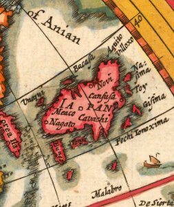
island of california on world maps
tresor des cartes geographiques (1659)
latin-language maps
1660s maps of the world
atlas novus (blaeu)
maps of the ottoman empire by mercator-hondius
17th-century maps of the indian ocean
17th-century maps of iceland
copper engravings
17th-century maps of catalonia
coats of arms of catalonia
the generall historie of virginia (john smith)
17th-century maps of bermuda
17th-century maps of the world
maps by frederick de wit
17th-century maps of the world
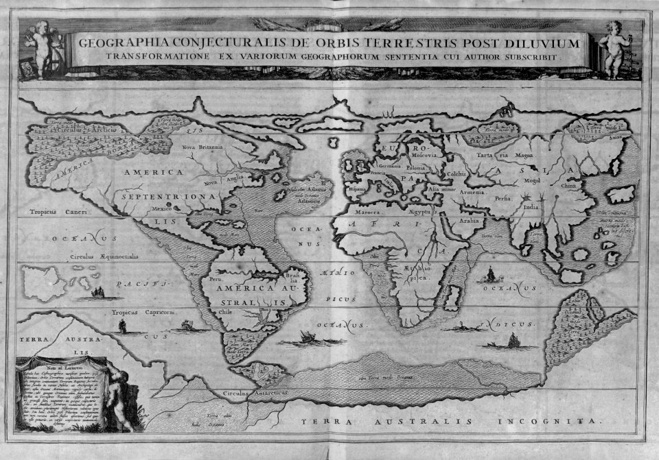
description de l'universe
maps made in the 17th century
old maps of the world
17th-century maps of the world
description de l'universe
vintage
maps
allegories of the four elements
islands of california
allegories of the four elements
islands of california
world
maps
maps made in the 17th century
maps by pieter schenk (i)
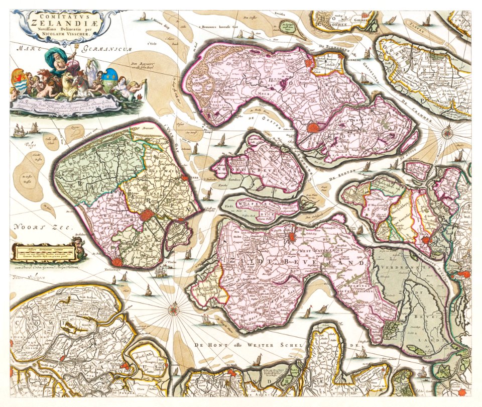
maps by nicolaes visscher i
claes jansz. visscher (ii)
maps by willem and johannes blaeu
atlas van loon
al-andalus
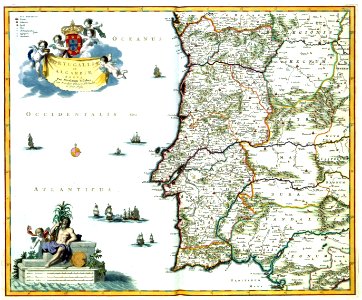
portugal
democritus by velazquez
baroque
illustrated title pages
1645 books
1690s maps of the world
copper engravings
maps by nicolaes visscher i
prints by nicolaes berchem
maps by willem and johannes blaeu
1660s maps of the world
maps by willem and johannes blaeu
novus atlas blaeu
island of california on world maps
1650s maps of the world
maps by hendrik hondius the younger
1640s maps of the world
1690s maps of the world
maps by carolus allard
willem schouten
willem blaeu
nypl lionel pincus and princess firyal map division
geographical atlases
tresor des cartes geographiques (1659)
1650s maps of india
1660s maps of the world
atlas maior
maps by jodocus hondius
copper engravings
tresor des cartes geographiques (1659)
17th-century maps of siberia
maps in the library of congress
1664 maps
atlas maior, vol 1 (northern europe, norway, and denmark) - joan blaeu, 1667 - bl 114.h(star).1
17th-century double hemisphere world maps
maps of the ottoman empire by mercator-hondius
eran laor cartographic collection
tresor des cartes geographiques (1659)
1650s maps of the world
maps by jodocus hondius
maps by petrus bertius
1645 maps of belgium
tournaisis
1630s maps of new york city
manatus map
maps in the rijksmuseum amsterdam
maps by frederick de wit
17th-century double hemisphere world maps
1610s maps of the world
maps by hendrik hondius the younger
1630s maps of the world
17th-century maps of trinidad and tobago
animals on maps
tresor des cartes geographiques (1659)
17th-century maps of silesia
maps of the ottoman empire by mercator-hondius
eran laor cartographic collection
atlas minor gerardi mercatoris (1614, maps)
17th-century double hemisphere world maps
still-life paintings of musical instruments
bartolomeo bettera
maps of the ottoman empire by mercator-hondius
eran laor cartographic collection
maps of the ottoman empire by mercator-hondius
eran laor cartographic collection
maps by willem and johannes blaeu
17th-century maps of sumatra
17th-century maps of the indian ocean
maps by willem and johannes blaeu
17th-century maps of the indian ocean
maps by willem and johannes blaeu
17th-century maps of the malay archipelago
tresor des cartes geographiques (1659)
tresor des cartes geographiques (1659)
17th-century maps of the arctic
tresor des cartes geographiques (1659)
17th-century maps of scandinavia
tresor des cartes geographiques (1659)
17th-century celestial maps
tresor des cartes geographiques (1659)
17th-century maps of morocco
tresor des cartes geographiques (1659)
17th-century maps of the british isles
tresor des cartes geographiques (1659)
17th-century maps of morocco
maps by willem and johannes blaeu
17th-century maps of the world
maps of the ottoman empire by mercator-hondius
eran laor cartographic collection
maps of the ottoman empire by mercator-hondius
eran laor cartographic collection
atlas ou representation du monde universel t. 1 (1633)
17th-century double hemisphere world maps
maps of the palatinate of the rhine
maps by willem and johannes blaeu
maps in the library of congress
1690s maps of the world
maps by willem and johannes blaeu
17th-century maps of france
17th-century maps of the mediterranean sea
portolan charts made in the 17th century
arnold van langren map of southwest africa
1600 maps of africa
atlas van der hagen (volume 4)
people with animals in art
17th-century double hemisphere world maps
mercator 1587 world map
17th-century maps of silesia
coats of arms on maps
old maps of trinidad and tobago
17th-century maps of venezuela
coats of arms of the kingdom of navarre
coats of arms of the crown of aragon
maps by willem and johannes blaeu
17th-century maps of the world
engravings by romeyn de hooghe
engravings by jan luyken
old maps of nassau
salomon rogiers
maps of île-de-france by françois de la guillotière
context files from gallica
maps by joachim bormeester
1680s maps of the world
1740s maps of the world
maps by emanuel bowen
maps of the ottoman empire by mercator-hondius
map
maps by willem and johannes blaeu
1640s maps
17th-century paintings in the amsterdam museum
paintings by pieter isaacsz
atlas ou representation du monde universel t. 2 (1633)
17th-century maps of southeast asia
cartography
maps
17th-century maps of the mediterranean sea
1610 maps of europe
17th-century maps of the indian ocean
maps by willem and johannes blaeu
riga in the 17th century
old maps of riga
17th-century maps of the indian ocean
maps by willem and johannes blaeu
18th-century double hemisphere world maps
1730s maps of the world
18th-century double hemisphere world maps
1730s maps of the world
17th-century double hemisphere world maps
description de l'universe
17th-century maps of thuringia
atlas novus (blaeu)
pieter verbiest (ii)
maps from gallica
atlas ou representation du monde universel t. 2 (1633)
nicolaes visscher i
17th-century maps of the indian ocean
maps by willem and johannes blaeu
mappe-monde geo-hydrographique (sanson and jaillot, 1674)
cartography of france
old maps of the western hemisphere
jacob van meurs
sanson maps of the netherlands
alexis-hubert jaillot
1650s maps of the americas
1658 maps
cartouches by alexis-hubert jaillot
cartouches by sanson family
maps of saint paul's journeys
maps by pieter van der keere
atlas ou representation du monde universel t. 1 (1633)
17th-century maps of scandinavia
1 - 100 of 128
Next page
/ 2


![Treasure of geographical maps of the main states of the universe [...], 1659](https://cdn.creazilla.com/illustrations/10000992784/treasure-of-geographical-maps-of-the-main-states-of-the-universe-1659-md.jpg)


![Treasure of geographical maps of the main states of the universe [...], 1659](https://cdn.creazilla.com/illustrations/10001176343/treasure-of-geographical-maps-of-the-main-states-of-the-universe-1659-md.jpg)
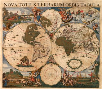
![[Nova et accuratissima totius terrarum orbis tabula]., Joan Blaeu, 1664](https://cdn.creazilla.com/illustrations/10001308540/nova-et-accuratissima-totius-terrarum-orbis-tabula-joan-blaeu-1664-md.jpg)


![Treasure of geographical maps of the main states of the universe [...], 1659](https://cdn.creazilla.com/illustrations/10001492378/treasure-of-geographical-maps-of-the-main-states-of-the-universe-1659-md.jpg)


![Treasure of geographical maps of the main states of the universe [...], 1659](https://cdn.creazilla.com/illustrations/10000859170/treasure-of-geographical-maps-of-the-main-states-of-the-universe-1659-md.jpg)


![Treasure of geographical maps of the main states of the universe [...], 1659](https://cdn.creazilla.com/illustrations/10000757788/treasure-of-geographical-maps-of-the-main-states-of-the-universe-1659-md.jpg)
![Treasure of geographical maps of the main states of the universe [...], 1659](https://cdn.creazilla.com/illustrations/10001044907/treasure-of-geographical-maps-of-the-main-states-of-the-universe-1659-md.jpg)
![Treasure of geographical maps of the main states of the universe [...], 1659](https://cdn.creazilla.com/illustrations/10000436833/treasure-of-geographical-maps-of-the-main-states-of-the-universe-1659-md.jpg)
![Treasure of geographical maps of the main states of the universe [...], 1659](https://cdn.creazilla.com/illustrations/10000284064/treasure-of-geographical-maps-of-the-main-states-of-the-universe-1659-md.jpg)
![Treasure of geographical maps of the main states of the universe [...], 1659](https://cdn.creazilla.com/illustrations/10000171002/treasure-of-geographical-maps-of-the-main-states-of-the-universe-1659-md.jpg)
![Treasure of geographical maps of the main states of the universe [...], 1659](https://cdn.creazilla.com/illustrations/10001373480/treasure-of-geographical-maps-of-the-main-states-of-the-universe-1659-md.jpg)
![Treasure of geographical maps of the main states of the universe [...], 1659](https://cdn.creazilla.com/illustrations/10000859165/treasure-of-geographical-maps-of-the-main-states-of-the-universe-1659-md.jpg)


![Gerardi Mercatoris and I. Hondii Atlas or Representation of the Universal World, and of the Parts of It, Made in Tables and Descriptions Very Ample, and Exact: Divided into Two Volumes [...]. [t. 1].](https://cdn.creazilla.com/illustrations/10000622971/gerardi-mercatoris-and-i-hondii-atlas-or-representation-of-the-universal-world-and-of-the-parts-of-it-made-in-tables-and-descriptions-very-ample-and-exact-divided-into-two-volumes-t-1-md.jpg)


![Titelblad] AFRICA](https://cdn.creazilla.com/illustrations/10000408184/titelblad-africa-sm.webp)


![Gerardi Mercatoris and I. Hondii Atlas or Representation of the Universal World, and of the Parts of It, Made in Tables and Very Ample Descriptions. [t. 2].](https://cdn.creazilla.com/illustrations/10000597422/gerardi-mercatoris-and-i-hondii-atlas-or-representation-of-the-universal-world-and-of-the-parts-of-it-made-in-tables-and-very-ample-descriptions-t-2-md.jpg)


![Gerardi Mercatoris and I. Hondii Atlas or Representation of the Universal World, and of the Parts of It, Made in Tables and Very Ample Descriptions. [t. 2]., Nicolaes Visscher](https://cdn.creazilla.com/illustrations/10000298847/gerardi-mercatoris-and-i-hondii-atlas-or-representation-of-the-universal-world-and-of-the-parts-of-it-made-in-tables-and-very-ample-descriptions-t-2-nicolaes-visscher-sm.webp)


![Gerardi Mercatoris and I. Hondii Atlas or Representation of the Universal World, and of the Parts of It, Made in Tables and Descriptions Very Ample, and Exact: Divided into Two Volumes [...]. [t. 1].](https://cdn.creazilla.com/illustrations/10001541341/gerardi-mercatoris-and-i-hondii-atlas-or-representation-of-the-universal-world-and-of-the-parts-of-it-made-in-tables-and-descriptions-very-ample-and-exact-divided-into-two-volumes-t-1-md.jpg)