Log in
All resources
Create a design
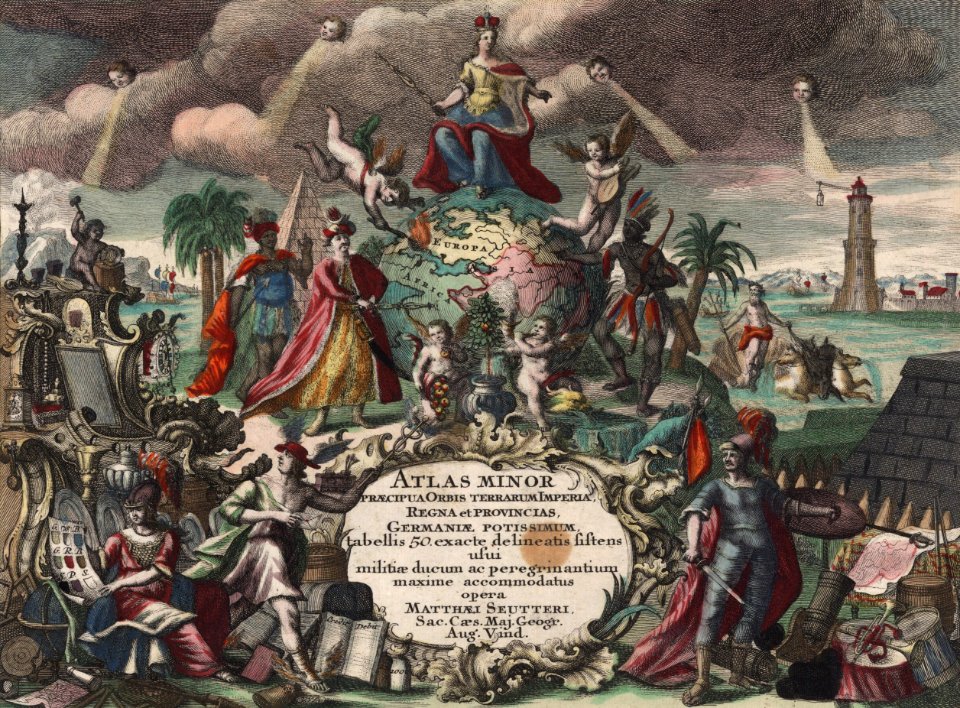
63 Free Artworks of Maps With Angels
bibliothèque nationale de france
angels on maps
maps with figures
maps with cartouches
guillaume sanson
copper engraving print
joan blaeu
atlas van der hagen
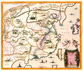
novus atlas sinensis
maps by pieter van der keere
people
maps
charts and maps of the royal museums greenwich
1682 maps
17th-century maps of france
maps with cartouches
maps with cartouches
atlas van der hagen
engravings of angels
fairies in art
color engravings
cornucopia
expressionism,symbolism,bauhaus
photos of mercury by messenger
maya angelou
travel maps
atlas maior, vol 11 (asia) - joan blaeu, 1667 - bl 114.h(star).11
1667 maps
atlas van der hagen (volume 4)
atlas van der hagen
island of california on world maps
1650s maps of the world
carta hydrographica y chorographica de las yslas filipinas
baroque painting
curt teich postcard archives
map postcards
18th-century maps of rome
neoclassicism
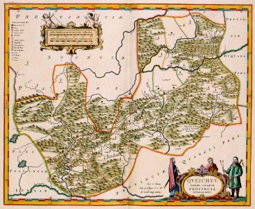
cartouches by sanson family
pierre mariette i
maps with cartouches
old maps of fujian
atlas maior, vol 1 (northern europe, norway, and denmark) - joan blaeu, 1667 - bl 114.h(star).1
17th-century double hemisphere world maps
paintings by rembrandt in the rijksmuseum amsterdam
dutch golden age painting
atlas maior, vol 11 (asia) - joan blaeu, 1667 - bl 114.h(star).11
1667 maps
maps by pieter van der keere
maps by abraham ortelius
18th-century maps of japan
works after jan goeree
atlas van der hagen (volume 4)
old maps of guizhou
maps in the british museum
1610s maps of ireland
barcelona in the 1800s
maps by juan lopez
map of the circle of austria by sanson
1700s maps of austria
1810s maps of portugal
maps by tomas lopez
1610s maps of the holy roman empire
jacques surhon
maps of the land of valkenburg
guillaume sanson
old maps of norway
guillaume sanson
ranchos of los angeles county, california
lucien labaudt
sanson map of the german empire (17th century)
sanson maps of the circles of germany
sanson map of the german empire (17th century)
sanson maps of the circles of germany
sanson map of the german empire (17th century)
sanson maps of the circles of germany
maps in the british museum
prints by albert flamen
cartography
maps
old maps of the county of ravensberg
burg limberg
german renaissance,northern renaissance
maps in the british museum
descriptio daciarum (17th-century map)
maps by pieter van der keere
maps by nicolaes visscher i
maps by daniel stoopendaal
history of puebla, puebla
biblioteca palafoxiana
maps by willem and johannes blaeu
old maps of capitanata
1667 sanson map of africa
1702 maps of africa
17th-century maps of the holy roman empire
maps by pieter van der keere
maps in the rijksmuseum amsterdam
18th-century maps of japan
veteris novae que urbis amstelodamensis ichnographia, continens publica aedificia ; veterem subnigrioribus... delineata auctore d. stalpaert - btv1b53212660h
bibliothèque nationale de france
veteris novae que urbis amstelodamensis ichnographia, continens publica aedificia ; veterem subnigrioribus... delineata auctore d. stalpaert - btv1b53212660h
bibliothèque nationale de france
johann christian wentzinger
baroque
old maps of norway
guillaume sanson
bibliothèque nationale de france
maps of wales by humphrey llwyd
bibliothèque nationale de france
guillaume sanson
old maps of norway
guillaume sanson
map of the circle of swabia by sanson
bibliothèque nationale de france
maps of lake geneva by jacques goulart
bibliothèque nationale de france
maps of lake geneva by jacques goulart
bibliothèque nationale de france
bibliothèque nationale de france
guillaume sanson
old maps of norway
guillaume sanson
bibliothèque nationale de france
1667 sanson map of africa
bibliothèque nationale de france
maps of wales by humphrey llwyd
prints by albertus clouwet in the rijksmuseum amsterdam
nicolau cotoner i d’olesa
maps by jean-baptiste bourguignon d'anville
1750s maps of the caribbean
portrait paintings by carl fredric von breda
maps of africa in art
equestrian engravings of monarchs
antoon van der does
maps in the rijksmuseum amsterdam
tower of babel in engravings
1 - 63 of 63
/ 1