Log in
All resources
Create a design
26,489 Free Artworks of Map
bibliothèque nationale de france
maps by willem and johannes blaeu
maps of spain by tomas lopez
maps in the library of congress
joan blaeu
details of old maps, defaced
the turkish empire in europe, asia and africa (1752)
baroque
paper
british museum
naval battles involving the ottoman empire in art
bombardment of algiers (1783)
bird's eye view maps of pennsylvania
p.s. duval & son
old maps of rennes
adolphe périaux
maps by alexis-hubert jaillot
old maps of the tyrol
old maps of siberia
erik palmqvist
old maps of siberia
erik palmqvist
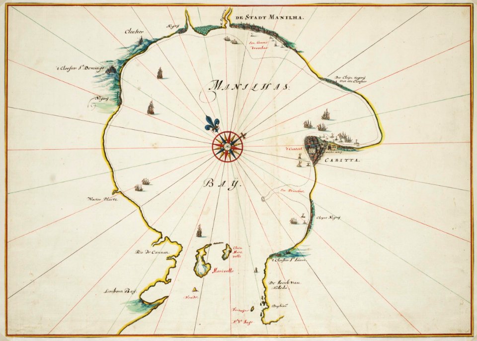
old maps of kobe
1872 in kobe
topographia braunschweig lüneburg (merian)
baroque
maps of wachtendonk
atlas van loon
maps of impact craters on mars
maps of hellas quadrangle
lawrence h. slaughter collection of english maps, charts, globes, books and atlases
maps by claude joseph sauthier
palatinatus rheni (merian)
baroque
africa and its inhabitants, vol. ii
charles eugène perron
africa and its inhabitants, vol. ii
charles eugène perron
old maps of washington, d.c.
pre-raphaelite brotherhood
turgot map of paris, david rumsey historical map collection – derivative files
petit-gentilly
la virginea pars
secotan
old maps of asturias
1777 maps of spain
old maps of asturias
1777 maps of spain
old maps of the region of murcia
maps of spain by tomas lopez
old maps of asturias
1777 maps of spain
maps of spain by tomas lopez
1768 maps of spain
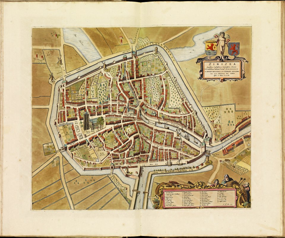
old maps of zierikzee
copper engravings
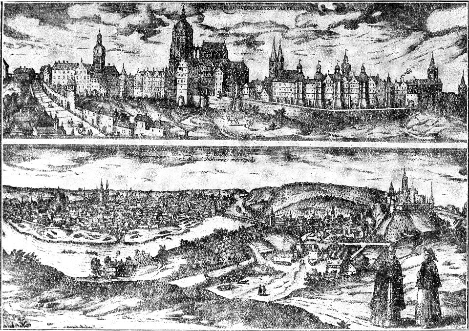
the story of prague (1920)
prague in art
map of maastricht by willem and johannes blaeu (1649)
jezuïetenwal (maastricht)
maps in the library of congress
1777 maps of new york (state)
flemish prints in the british museum
coenraed lauwers
maps from university of amsterdam special collections
atlas der neederlanden
atlas vingboons
1665
maps in the library of congress
pre-raphaelite brotherhood
maps in the library of congress
1850 maps of new york (state)
old maps of veliky novgorod
maps of velikiy novgorod
details of old maps, defaced
old maps of samsun
the turkish empire in europe, asia and africa (1752)
historical maps of adana
the turkish empire in europe, asia and africa (1752)
maps of the history of turkey
details of old maps, defaced
maps of erzurum province
the turkish empire in europe, asia and africa (1752)
old maps of baghdad
sanborn maps of manhattan published in 1903
art nouveau
maps of galicia by mercator-hondius
kingdom of bohemia (1867–1918)
20th-century maps of bohemia
eran laor cartographic collection
caspar merian
eran laor cartographic collection
jacob peeters
sheets of stamps of russia, 2023
stamps of russia, 2023
gemeente atlas van nederland - utrecht
maps of houten
atlas maior, vol 2 (sweden, russia, poland, eastern europe, and greece) - joan blaeu, 1667 - bl 114.h(star).2
1667 maps of russia
maps in the amsterdam museum
1690s maps of palestine
atlas maior, vol 1 (northern europe, norway, and denmark) - joan blaeu, 1667 - bl 114.h(star).1
1667 maps
géographie générale; physique, politique et économique (1876)
1870s maps of germany
nouvelle géographie universelle, vol. xii
old maps of la gomera
thomas robert macquoid
maps of the ardennes
19th-century maps of southern africa
1890s maps of africa
maps from the earth and its inhabitants, vol. v
19th-century maps of scandinavia
géographie générale; physique, politique et économique (1876)
1870s maps of china
1880s maps of the netherlands
1880s maps of belgium
historical maps of baía de todos os santos
maps by willem and johannes blaeu
historical maps of baía de todos os santos
maps by willem and johannes blaeu
voyages and travels to india, ceylon, the red sea, abyssinia, and egypt, vol. 2
henry cooper (engraver)
maps from the earth and its inhabitants, vol. iv
topographic maps of scotland
maps of brest from bibliothèque nationale de france
lithographs of brest, france
maps of bremen by braun & hogenberg
maps of mitte (bremen)
maps by willem and johannes blaeu
old maps of alkmaar
maps by willem and johannes blaeu
old maps of enkhuizen
maps by willem and johannes blaeu
old maps of dokkum
maps by willem and johannes blaeu
old maps of gouda
maps by willem and johannes blaeu
old maps of nijmegen
1760s maps of the americas
1760 maps
maps in the library of congress
plan de roussel
mapa del principado de cataluña (1776)
18th-century maps of catalonia
17th-century maps of sardinia
maps by gerard valck
maps in the library of congress
birds-eye view of seattle, 1884
19th-century maps of the mediterranean sea
the bottom of the sea (1870)
maps from university of amsterdam special collections
atlas der neederlanden
maps from university of amsterdam special collections
atlas der neederlanden
18th-century maps of western europe
1754 maps of europe
17th-century maps of the mediterranean sea
portolan charts made in the 17th century
jean-baptiste-henri delahaye
philippe buache
avignon in the 17th century
atlas van loon
mandrud dynasty paintings
yushan school
maps of county armagh
1760s maps of ireland
geographia universalis (1545) in the british museum
german renaissance,northern renaissance
geographia universalis (1545) in the british museum
german renaissance,northern renaissance
1869 advertisements
1869 in boston
kanonenteich (leipzig)
adolf eltzner
maps by abraham ortelius
old maps of zeeland
maps of hulsterse bolwerken
history of axel
st. johanniskloster (hamburg-altstadt)
maps of hamburg by braun & hogenberg
maps of the napoleonic wars
emery walker
maps from the earth and its inhabitants, vol. iv
maps of glenmore
the cruise of the marchesa (1889)
19th-century maps of new guinea
maps of goa by linschoten
baroque
australia (1873) by booth
1870s maps of australia
maps in the phoebus foundation
1662 maps
gemeente atlas van nederland - north holland
maps of egmond aan zee
maps of rottnest island
daisy bates
maps from the earth and its inhabitants, vol. x
1890 maps of africa
lechenich
baroque
turgot map of paris, norman b. leventhal map center – derivative files
sheet 9 of the turgot map of paris
maps of amersfoort by braun & hogenberg
rce suggested: stadsplattegrond
maps of amersfoort by braun & hogenberg
rce suggested: stadsplattegrond
bodleian maps collection
pictorial maps
6201 - 6300 of 26,489
Next page
/ 265