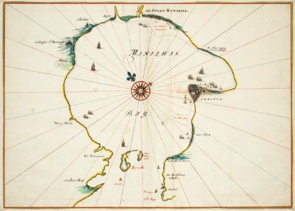
Map of the bay of Manila, Johannes Vingboons, circa 1665
Title in the leupe catalogue (na): kaart van de baai van manilla. Map of the bay of manila. Remarks: the chart forms part of the vingboons atlas. This map corresponds to the chart contained in f. Valentijn, oud en nieuw oost-indien i, p. 148. Date: circa 1665. Dimensions: height: 65 cm (25.5 in); width: 46 cm (18.1 in). Medium: watercolour on paper. Collection: Nationaal Archief. AMH-6764-NA Map of the bay of Manila