Log in
All resources
Create a design
26,489 Free Artworks of Map
bibliothèque nationale de france
beschreibung und contrafactur der vornembster stät der welt, liber primus civitates orbis terrarum
tresor des cartes geographiques (1659)
baroque
maps of paris from bibliothèque nationale de france
maps from the earth and its inhabitants, vol. xiv
géographie générale; physique, politique et économique (1876)
maps from the earth and its inhabitants, vol. iv
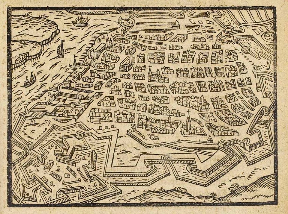
merian plan of paris
david rumsey historical map collection
miscellaneous items in high demand, ppoc, library of congress
maps by claude joseph sauthier
carte figurative de l'instruction populaire de la france
maps from gallica
beschreibung und contrafactur der vornembster stät der welt, liber primus civitates orbis terrarum
maps of vienna by braun & hogenberg
tresor des cartes geographiques (1659)
1650s maps of the ottoman empire
17th-century maps of the malay archipelago
tresor des cartes geographiques (1659)
beschreibung und contrafactur der vornembster stät der welt, liber primus civitates orbis terrarum
maps of lisbon by braun & hogenberg (1572)
maps of candia by ortelius and mercator
tresor des cartes geographiques (1659)
beschreibung und contrafactur der vornembster stät der welt, liber primus civitates orbis terrarum
maps of toledo by braun & hogenberg
tresor des cartes geographiques (1659)
17th-century celestial maps
tresor des cartes geographiques (1659)
maps of guinea by mercator-hondius
tresor des cartes geographiques (1659)
17th-century maps of morocco
tresor des cartes geographiques (1659)
old maps of the whole peloponnese
tresor des cartes geographiques (1659)
1650s maps of the iberian peninsula
beschreibung und contrafactur der vornembster stät der welt, liber primus civitates orbis terrarum
maps of gorinchem by braun & hogenberg
beschreibung und contrafactur der vornembster stät der welt, liber primus civitates orbis terrarum
maps of écija by braun & hogenberg
beschreibung und contrafactur der vornembster stät der welt, liber primus civitates orbis terrarum
maps of prague by braun & hogenberg
beschreibung und contrafactur der vornembster stät der welt, liber primus civitates orbis terrarum
maps of burgos by braun & hogenberg
tresor des cartes geographiques (1659)
17th-century maps of scandinavia
tresor des cartes geographiques (1659)
17th-century maps of morocco
tresor des cartes geographiques (1659)
17th-century maps of the arctic
beschreibung und contrafactur der vornembster stät der welt, liber primus civitates orbis terrarum
maps of mons (hainaut) by braun & hogenberg
beschreibung und contrafactur der vornembster stät der welt, liber primus civitates orbis terrarum
maps of marburg by braun & hogenberg
beschreibung und contrafactur der vornembster stät der welt, liber primus civitates orbis terrarum
maps of genoa by braun & hogenberg
beschreibung und contrafactur der vornembster stät der welt, liber primus civitates orbis terrarum
maps of frankfurt (oder) by braun & hogenberg
maps of barbary coast by mercator-hondius
tresor des cartes geographiques (1659)
maps of prague by braun & hogenberg
maps of cheb by braun & hogenberg
beschreibung und contrafactur der vornembster stät der welt, liber primus civitates orbis terrarum
maps of dresden by braun & hogenberg
beschreibung und contrafactur der vornembster stät der welt, liber primus civitates orbis terrarum
maps of lübeck by braun & hogenberg
beschreibung und contrafactur der vornembster stät der welt, liber primus civitates orbis terrarum
maps of tours by braun & hogenberg
tresor des cartes geographiques (1659)
maps of cyprus by mercator-hondius
beschreibung und contrafactur der vornembster stät der welt, liber primus civitates orbis terrarum
maps of sion by braun & hogenberg
beschreibung und contrafactur der vornembster stät der welt, liber primus civitates orbis terrarum
maps of famagusta by braun & hogenberg
beschreibung und contrafactur der vornembster stät der welt, liber primus civitates orbis terrarum
maps of lisbon by braun & hogenberg (1572)
beschreibung und contrafactur der vornembster stät der welt, liber primus civitates orbis terrarum
maps of rouen by braun & hogenberg
tresor des cartes geographiques (1659)
17th-century maps of the british isles
bibliothèque nationale de france
guillaume sanson
1667 sanson map of africa
1667 maps of africa
beschreibung und contrafactur der vornembster stät der welt, liber primus civitates orbis terrarum
maps of arras by braun & hogenberg
tresor des cartes geographiques (1659)
1650s maps of the holy roman empire
maps of barbary coast by mercator-hondius
tresor des cartes geographiques (1659)
merian sueviae
baroque
navigantium atque itinerantium bibliotheca
1744 fleurons
incidents of travel in central america, chiapas, and yucatan (1858)
romanticism
orientalist painting
old maps of dakar
topographischer atlas der schweiz
maps of aletschgletscher
maps of antwerp by braun & hogenberg
theatrum urbium (1610)
prints by ambrogio brambilla
old maps of parma
volume 12 of le tour du monde
academic art
maps of paris from bibliothèque nationale de france
baroque
maps of paris from bibliothèque nationale de france
baroque
lutetia parisiorum urbs, toto orbe celeberrima notissimaque caput regni franciæ by sebastian münster
maps of paris from bibliothèque nationale de france
maps of buenos aires
aduana taylor
largo di palazzo (naples)
mannerism
maps of paris from bibliothèque nationale de france
baroque
lutetia parisiorum urbs, toto orbe celeberrima notissimaque caput regni franciæ by sebastian münster
maps of paris from bibliothèque nationale de france
17th-century maps of the americas
maps by jodocus hondius
old maps of atlantis
island of california
eran laor cartographic collection
pierre mortier
eran laor cartographic collection
alexis-hubert jaillot
maps of brest, france by antoine aveline
brest (france) in the 1700s
british library - off the map alice collection - wonderland
british library - off the map alice collection
maps from the earth and its inhabitants, vol. iv
topographic maps of scotland
korte beschryvinghe (1686)
old maps of tripoli
maps by johannes vingboons
old maps of south holland
map of paris by claes jansz. visscher - derivate files
île de la cité in art
james reynolds (publisher)
john emslie
jewish cemetery battonnstraße
fabers belagerungsplan
david rumsey historical map collection
1794 maps of the holy roman empire
david rumsey historical map collection
1790s maps of the holy roman empire
engravings by matthäus merian
baroque
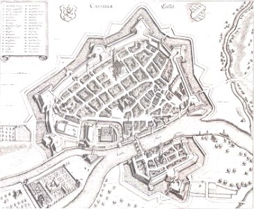
maps of goa by braun & hogenberg
old goa
sanson maps of the holy land
old maps of canaan
johann stridbeck the younger
old maps of the tyrol
maps from university of amsterdam special collections
atlas der neederlanden
malta (galleria delle carte geografiche)
old maps of malta
jean-fréderic phélypeaux
guillaume dheulland
maps by herman moll
john perry
jean-fréderic phélypeaux
guillaume dheulland
nouveau cours d'instruction primaire de géographie (1886)
topographic maps of france
picturesque burma, past and present (1897)
1890s maps showing history
maps from the earth and its inhabitants, vol. xiv
1890s maps of indonesia
maps from the earth and its inhabitants, vol. xiv
1890s maps of australia
maps from the earth and its inhabitants, vol. xiv
1890s maps of new zealand
géographie générale; physique, politique et économique (1876)
old maps of rivers of france
géographie générale; physique, politique et économique (1876)
1870s maps of australia
physical geography (1899) by davis
1899 maps of oregon
maps from the earth and its inhabitants, vol. iv
maps of balmoral castle
maps from the earth and its inhabitants, vol. x
1880s maps of egypt
nouveau cours d'instruction primaire de géographie (1886)
1886 maps of europe
maps from the earth and its inhabitants, vol. xiv
1890 maps of africa
maps from the earth and its inhabitants, vol. xiv
old maps of adelaide
géographie générale; physique, politique et économique (1876)
1870s maps of the atlantic ocean
maps from the earth and its inhabitants, vol. iv
old maps of hastings, england
maps from the earth and its inhabitants, vol. iv
old maps of cardiff
géographie générale; physique, politique et économique (1876)
hydrographic maps of argentina
maps of the rocky mountains
1810s maps of canada
géographie générale; physique, politique et économique (1876)
1876 maps of italy
19th-century maps of cornwall
19th-century maps of devon
maps of the west indies federation
1810s maps of the caribbean
picturesque burma, past and present (1897)
1890s maps showing history
12301 - 12400 of 26,489
Next page
/ 265