Log in
All resources
Create a design
26,489 Free Artworks of Map
bibliothèque nationale de france
géographie générale; physique, politique et économique (1876)
eran laor cartographic collection
sanson maps of north america
island of california
latin-language maps
maps by thomas kitchin
thomas kitchin
frans hogenberg
nieuwe en beknopte hand-atlas (1754)
géographie générale; physique, politique et économique (1876)
19th-century maps of borneo
nouveau cours d'instruction primaire de géographie (1886)
economic maps of france
géographie générale; physique, politique et économique (1876)
19th-century maps of pomerania
physical geography (1899) by davis
1899 maps of oregon
géographie générale; physique, politique et économique (1876)
19th-century maps of the nile river
maps of the seine river
1886 maps of france
géographie générale; physique, politique et économique (1876)
1870s maps of austria
picturesque burma, past and present (1897)
1890s maps showing history
nouvelle géographie universelle, vol. v
maps of orenburg oblast
a system of modern geography (1810)
1810 maps of germany
physical geography (1899) by davis
1899 maps of pennsylvania
picturesque burma, past and present (1897)
19th-century maps of myanmar
géographie générale; physique, politique et économique (1876)
18th-century maps of alpes-maritimes
géographie générale; physique, politique et économique (1876)
1876 maps of turkey
la palestine (1883, by chardin)
travel maps of palestine
géographie générale; physique, politique et économique (1876)
19th-century maps of java
maps from the earth and its inhabitants, vol. iii
1880s maps of vienna
maps of wallachia by gerardus mercator
maps by willem and johannes blaeu
carte particulière des environs de paris
maps of saint-denis (seine-saint-denis)
nouvelle géographie universelle, vol. xii
old maps of saint-louis (senegal)
maps of eckernförde by braun & hogenberg
frans hogenberg
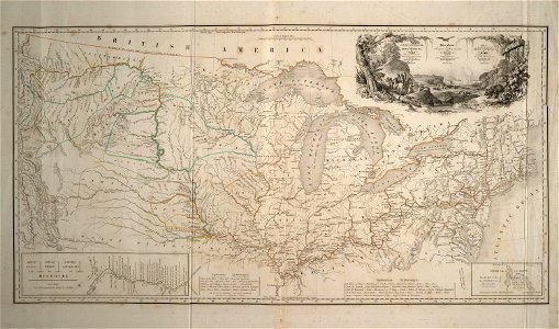
maps of the united states
barbizon school
maps from the earth and its inhabitants, vol. ix
old maps of samsun
maps of bremen by braun & hogenberg
maps made in the 16th century
maps by nicolaes visscher i
1660s maps of europe
maps by george w. boynton
1840s maps of boston
maps from encyclopædia britannica
emery walker
nieuwe en beknopte hand-atlas (1754)
old maps of curaçao
civitates orbis terrarum. de praecipuis totius universi urbibus. liber secundus
maps of tunis and la goleta by braun & hogenberg
andalusia in the 1590s
1590s maps of spain
old maps of lima
joseph mulder
ptolemy's first projection
ortelius oval projection
eran laor cartographic collection
gerard valck
eran laor cartographic collection
pieter van der keere
map collection of leibniz-institut für ost- und südosteuropaforschung
1733 maps of europe
eran laor cartographic collection
jacob van meurs
zur geschichte der kartographie nordalbaniens (map reconstructions)
coding da vinci: süd 2019
eran laor cartographic collection
willem blaeu
eran laor cartographic collection
joan blaeu
eran laor cartographic collection
nathaniel whittock
eran laor cartographic collection
william henry toms
prints by matteo greuter in the statens museum for kunst
copper
media from accademia delle scienze di torino
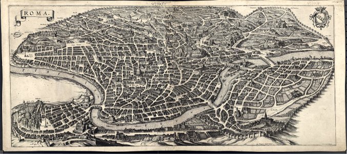
17th-century maps of rome
franz müller
carl schütz
old maps of scotland from the norman b. leventhal map center
old maps of ireland from the norman b. leventhal map center
van langren map of southeast asia
1595 maps of asia
maps in the stadsarchief amsterdam
carolus allard
a map of the british empire in america with the french and spanish settlements adjacent thereto
1730s maps of the caribbean
a map of the british empire in america with the french and spanish settlements adjacent thereto
1730s maps of the caribbean
a map of the british empire in america with the french and spanish settlements adjacent thereto
1730s maps of central america
maps by johann baptist homann
sanson maps of the holy land
sanson maps of north america
1674 maps of north america
sanson maps of north america
island of california
sanson maps of north america
island of california
sanson maps of north america
island of california
sanson maps of north america
island of california
sanson maps of north america
island of california
antoine-françois tardieu
maps from gallica
eberhard kieser
maps of barth
maps of the history of amsterdam
1670s engravings
maps from university of amsterdam special collections
atlas der neederlanden
historical images of bieraście
erik dahlbergh
dunkerque in art
eberhard kieser
maps of elmina by braun & hogenberg
elmina in the 1570s
atlas des anciens plans de paris by imprimerie nationale, 1880 from bhvp
maps of paris by braun & hogenberg
chicago and the midwest, newberry library
maps by rand mcnally
18th-century portrait paintings in the national maritime museum, london
john francis rigaud
maps by hendrik hondius the younger
1631 maps of africa
maps of the gulf of bothnia
ambroise tardieu
paris vers 1530 (plan de georges braun, "aux trois personnages")
maps of paris from bibliothèque nationale de france
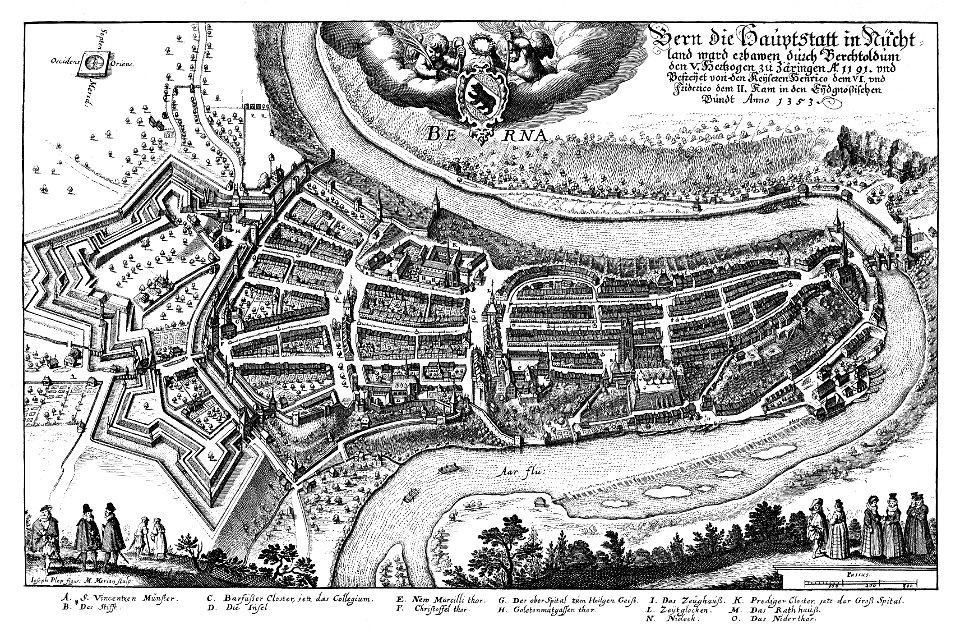
old maps of strasbourg
place broglie
fortifications of the eighty years' war
atlas van loon
a map of the provinces of new york and new jersey, with a part of pennsylvania and the province of quebec
old maps of valletta
baroque
maps by willem and johannes blaeu
17th-century maps of chile
18th-century maps of kent
maps by thomas kitchin
old maps of northumberland
maps by thomas kitchin
an accurate map of england and wales , drawn from all the particular surveys hitherto publish'd. illustrated with many additional improvements, and regulated by numerous astronomical observations made by... - btv1b53181614s
maps by thomas kitchin
an accurate map of england and wales , drawn from all the particular surveys hitherto publish'd. illustrated with many additional improvements, and regulated by numerous astronomical observations made by... - btv1b53181614s
maps by thomas kitchin
engravings of topographia helvetiae, rhaetiae et valesiae
baroque
danubius pannonico-mysicus
mehadia, caraș-severin
john rocque's 1748 map of london and adjacent country
remigius parr
north carolina algonquin
la virginea pars
bibliothèque nationale de france
maps by tomas lopez
maps of the course of the rhine by guillaume sanson
maps by nicolas sanson
maps by jodocus hondius
1590s maps of the world
16th-century maps of hispaniola
cornelius aurelius world map
royal city in polish–lithuanian commonwealth
maps of lviv by braun & hogenberg
nieuwe en beknopte hand-atlas (1754)
18th-century maps of panama
maps from the earth and its inhabitants, vol. iii
dobracz
nieuwe en beknopte hand-atlas (1754)
1754 maps of quebec
sconces in the netherlands
maps by isaak tirion
maps in the stadsarchief amsterdam
romeyn de hooghe
maps in the stadsarchief amsterdam
daniël veelwaard (i)
17th-century maps of rome
renaissance
gemeente atlas van nederland - south holland
maps of zevenhuizen
media contributed by university of illinois urbana-champaign university library
1794 maps of africa
history of bernkastel-kues
historic views of boppard
gemeente atlas van nederland - north brabant
andel, netherlands
old maps of trentino
1659 maps
12401 - 12500 of 26,489
Next page
/ 265