Log in
All resources
Create a design
27,441 Free Images of Maps
maps of africa
bibliothèque nationale de france
maps from the earth and its inhabitants, vol. xii
africa in the 1890s
koninklijke bibliotheek
gemeente atlas van nederland - south holland
1860s maps of south holland
colored engraving on paper
university of texas at arlington
map - museu antônio parreiras
old maps of leopoldstadt
old maps of brigittenau
eran laor cartographic collection
willem blaeu
maps by richard william seale
1750 maps of africa
drawings in the museu antônio parreiras
crayon
drawings in the museu antônio parreiras
crayon
gemeente atlas van nederland - south holland
maps of delfshaven
maps in the british museum
john cooke
old maps of former departments of france
maps from gallica
maps by willem and johannes blaeu
old maps of loiret
maps by jacques chiquet
1719 maps of africa
old county maps of the north riding of yorkshire
maps made in the 17th century
old maps of former departments of france
maps from gallica
map of the circle of the rhineland by sanson
1700s maps of rhineland-palatinate
maps by jacques chiquet
1719 maps of africa
17th-century maps of cheshire
old county maps of cheshire
1749 maps of the russian empire
hendrik de leth
maps from the earth and its inhabitants, vol. xii
africa in the 1890s
maps from the earth and its inhabitants, vol. xii
africa in the 1890s
maps from the earth and its inhabitants, vol. xi
africa in the 1890s
maps from the earth and its inhabitants, vol. xi
africa in the 1890s
maps from the earth and its inhabitants, vol. xii
africa in the 1890s
maps from the earth and its inhabitants, vol. xiii
africa in the 1890s
maps from the earth and its inhabitants, vol. xii
maps of africa
maps from the earth and its inhabitants, vol. xii
africa in the 1890s
maps from the earth and its inhabitants, vol. xii
maps of africa
maps from the earth and its inhabitants, vol. xii
africa in the 1890s
maps from the earth and its inhabitants, vol. xii
maps of africa
maps from the earth and its inhabitants, vol. xii
maps of africa
description de l'universe
old maps of asia
maps by pieter van der keere
old maps of utrecht
1600s maps of belgium
old maps of flanders
maps of the west-indische compagnie
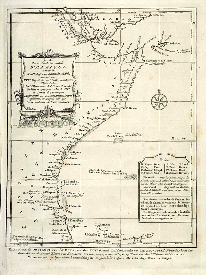
1705 maps of africa
19th-century maps of nord (department)
19th-century maps of pas-de-calais
maps by pieter van der keere
willem barentsz
maps by william home lizars
maps by daniel lizars
maps in the library of congress
1877 maps of the united states
john rocque 1746 london map (216 parts)
st paul's churchyard
map of bruges by marcus gheeraerts (i)
drawings in the groeningemuseum
maps of landrecies by braun & hogenberg
maps of beaumont by braun & hogenberg
map of bruges by marcus gheeraerts (i)
drawings in the groeningemuseum
map of bruges by marcus gheeraerts (i)
drawings in the groeningemuseum
map of bruges by marcus gheeraerts (i)
drawings in the groeningemuseum
geographic overlays
baroque
siege of steenwijk 1592
maps of steenwijk
media from accademia delle scienze di torino
high renaissance
paintings by antônio parreiras in the museu antônio parreiras
portrait paintings by antônio parreiras
media from accademia delle scienze di torino
1633 in rome
maps by girolamo porro
1596 maps of africa
maps by abraham ortelius
maps by petrus schenk
maps of spain by tomas lopez
1784 maps of spain
maps from the mechanical curator collection available to georeference
maps from the mechanical curator collection
1786 maps of spain
maps of el bierzo
old maps of fictional countries
the lost princess of oz
typus orbis terrarum
1572 maps
old maps of the ionian islands
the odyssey (butler)
atlas van der hagen (volume 3)
atlas van der hagen
brazilian paintings in the museu antônio parreiras
antônio rafael pinto bandeira
eran laor cartographic collection
avraham leib monsohn
description de l'universe
1710s maps of china
old maps of the eastern hemisphere
1710s maps of the world
maps of augsburg by braun & hogenberg
16th-century maps of augsburg
curt teich postcard archives
postcards of arizona
the geographical distribution of animals (book)
nearctic
the geographical distribution of animals (book)
neotropic
the geographical distribution of animals (book)
indomalayan fauna
map of ghent by foppens
map of ghent by foppens
old maps of the dutch gold coast
maps by johannes vingboons
maps in the staats- und universitätsbibliothek hamburg
1841 maps of hamburg
carte de la mer mediterranée (1764) by roux
eran laor cartographic collection
atlas van der hagen (volume 4)
german renaissance
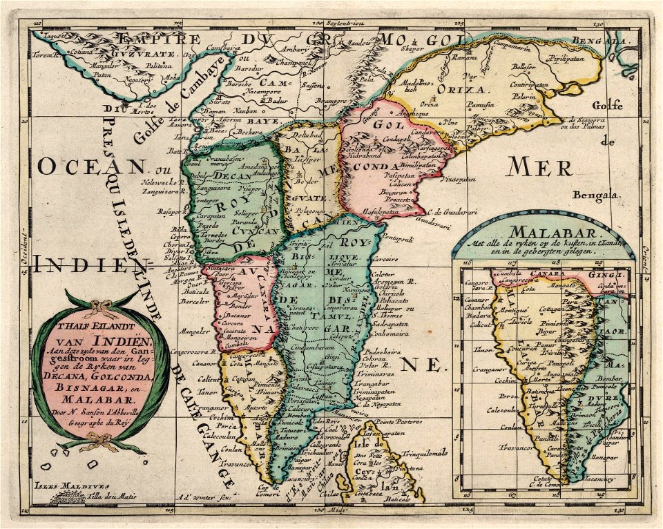
maps of the dutch east india company - india
1705
copper engravings by benjamin cole
maps of the city of westminster
maps of bremen by braun & hogenberg
maps of stade by braun & hogenberg
1840s maps of palestine
old maps of israel
gemeente atlas van nederland - south holland
1860s maps of south holland
maps by willem and johannes blaeu
old maps of schoonhoven
1880s maps of tunisia
tunisia in the 1880s
maps of ceylon by petrus plancius
ketheeswaram temple
cartes de franz schrader
1894 maps of france
18th-century maps of ireland
old maps of dublin
gemeente atlas van nederland - south holland
giessen (river south-holland)
18th-century maps of antwerp
maps of antwerp city walls
gemeente atlas van nederland - south holland
giessen (river south-holland)
gemeente atlas van nederland - south holland
maps of waddinxveen
incidents of travel in central america, chiapas, and yucatan (1841)
romanticism
gemeente atlas van nederland - south holland
1860s maps of south holland
maps of nieuw-helvoet
nieuw-helvoet
guide joanne espagne et portugal-1906
french-language maps of spain
old maps of north america from the norman b. leventhal map center
1740 maps of north america
maps by emanuel bowen
negroland
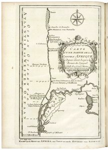
maps of the senegal river
1747 maps of africa
old maps of the dutch east india company - africa
1747 maps of africa
maps of the west-indische compagnie
1757 maps of south america
maps of the dutch east india company - indonesia
18th-century maps of java
maps of the course of the rhine by guillaume sanson
bibliothèque nationale de france
france
maps
maps from the earth and its inhabitants, vol. xi
1800s maps of algeria
maps from valentine's manual
george hayward
maps from the earth and its inhabitants, vol. xiii
africa in the 1890s
4101 - 4200 of 27,441
Next page
/ 275