Log in
All resources
Create a design
27,441 Free Images of Maps
miniature speed atlas (1627) pieter van den keere
pieter van den keere
bibliothèque nationale de france
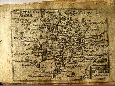
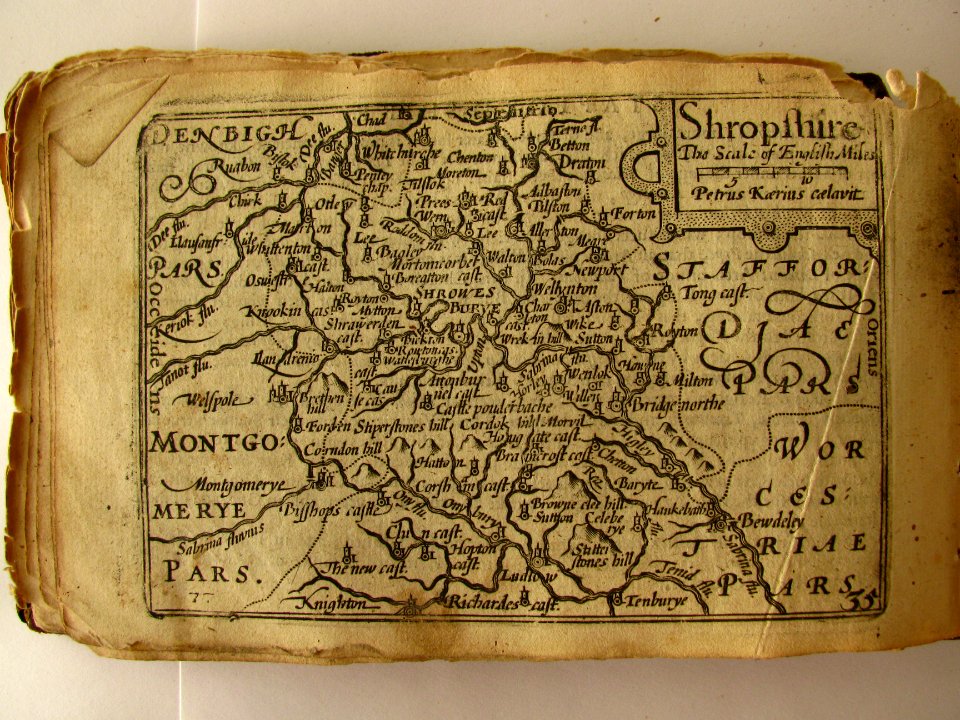
county maps of england by john speed
maps by willem and johannes blaeu
gemeente atlas van nederland - south holland
1860s maps of south holland
maps from university of amsterdam special collections
atlas der neederlanden
copperplate print
maps by willem and johannes blaeu
1640 maps
1747 persia map by emanuel bowen
1740s maps of georgia
maps of lithuania by gerardus mercator
1630s maps of lithuania
gemeente atlas van nederland - south holland
1860s maps of south holland
media contributed by the frick collection
naïve art
maps from university of amsterdam special collections
atlas der neederlanden
eran laor cartographic collection
emanuel bowen
eran laor cartographic collection
emanuel bowen
munich in the 17th century
baroque
maps by willem and johannes blaeu
siege of 's-hertogenbosch
city map of regensburg (1700)
obermünster (regensburg)
history of bernkastel-kues
city walls of bernkastel
1739 maps of france
plan de turgot
1739 maps of france
louis bretez
maps by willem and johannes blaeu
joan blaeu
maps from university of amsterdam special collections
atlas der neederlanden
maps from university of amsterdam special collections
atlas der neederlanden
maps of paris from the open data hauts-de-seine
1710s maps of paris
maps from university of amsterdam special collections
atlas der neederlanden
maps from the mechanical curator collection available to georeference
maps from the mechanical curator collection
georges barthélemy médéric flamand
chotts
engravings by jan luyken
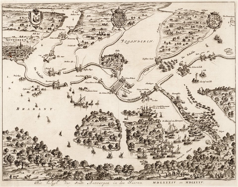
old maps of antwerp
church towers in hamburg
jan diricks van campen
maps in the staats- und universitätsbibliothek hamburg
1852 maps of hamburg
maps by frederick de wit
old maps of vollenhove
maps of sterrenburg (utrecht)
atlas van loon
media from atlas of mutual heritage on dutch east india company
1724
antoine-françois tardieu
pierre antoine tardieu
maps in the library of congress
1863 maps
encyclopédie méthodique - géographie physique
ambroise tardieu
coats of arms of perpignan
baroque painting,baroque
parts of old maps of hamburg
maps of hamburg-sternschanze
miniature speed atlas (1627) pieter van den keere
county maps of england by john speed
description de l'universe
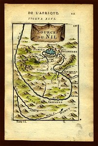
old maps of the nile
miniature speed atlas (1627) pieter van den keere
maps of wales by john speed
miniature speed atlas (1627) pieter van den keere
county maps of england by john speed
miniature speed atlas (1627) pieter van den keere
county maps of england by john speed
miniature speed atlas (1627) pieter van den keere
county maps of england by john speed
miniature speed atlas (1627) pieter van den keere
county maps of england by john speed
miniature speed atlas (1627) pieter van den keere
county maps of england by john speed
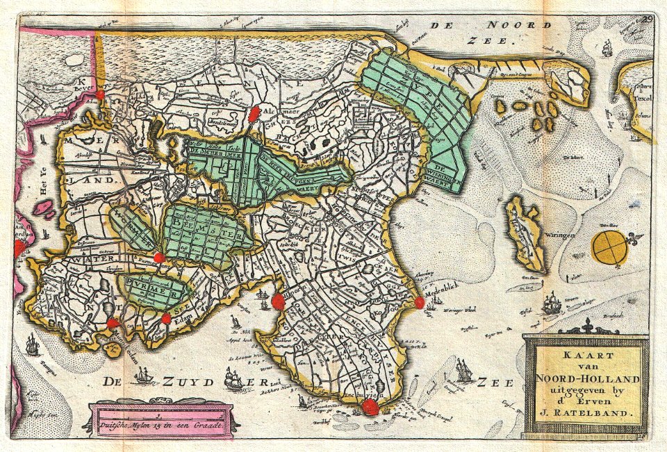
old maps of north holland
daniel de la feuille
1803 in berlin
1803 maps
18th-century maps of veneto
1700s maps of slovenia
maps from gallica
old maps of psarà
john rocque 1746 crops from library of congress
john rocque
media from the national library of finland
classicism
maps from the earth and its inhabitants, vol. xii
africa in the 1890s
maps from the earth and its inhabitants, vol. xi
1891 maps of africa
maps of the ottoman empire by mercator-hondius
map
maps by john cary
1799 maps
cornell: persuasive cartography: the pj mode collection
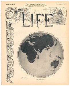
james montgomery flagg's life covers
prints in the staats- und stadtbibliothek augsburg
16th-century maps of augsburg
1942 watercolor paintings
works by eric ravilious
images of places from encyclopædia britannica
1910s maps of london
old maps of constantinople
emery walker
17th-century maps of slovenia
1640 maps
curt teich postcard archives
postcards of texas
the geographical distribution of animals (book)
afrotropic
maps of polders in south holland
old maps of westland
maps by jodocus hondius
maps by petrus bertius
old maps of narva
1700 maps
fine prints in the library of congress
impressionism
map of ghent by hadrianus barlandus
maps of ghent by braun & hogenberg
maps of paris from the david rumsey historical map collection
1778 in paris
old maps of england
1860 maps
19th-century maps of ghana
thomas edward bowdich
algeria in the 1880s
old maps of oran
1570s maps of russia
frans hogenberg
cartes de franz schrader
old maps of france
19th-century maps of ille-et-vilaine
1847 maps of france
maps of the history of sweden
maps of the kalmar union
bibliothèque municipale de reims, chgg 9
maps of châlons-en-champagne
guide joanne normandie-1912
1912 maps of france
hoogheemraadschap van rijnland
maps of woubrugge
daniel de la feuille
old maps of bavaria
18th-century maps of azerbaijan
maps by isaak tirion
old maps of siberia
erik palmqvist
maps of aegadian islands
the odyssey (butler)
maps of the west-indische compagnie
1705
print room of the university of antwerp
citadel van antwerpen
turgot map of paris, kyoto university library – derivative files
collège du plessis
map of paris by braun & hogenberg - derivative files
rue des archives (paris)
maps of london by sebastian münster
1598 maps of europe
old county maps of essex
christopher saxton
maps of nieuwpoort, south-holland
vestingwerken nieuwpoort
gemeente atlas van nederland - south holland
1860s maps of south holland
1857 maps of illinois
1850s maps of chicago
africa and its inhabitants, vol. ii
charles eugène perron
eran laor cartographic collection
latin-language maps
floor plans of fortresses
daugavgrīva castle
geografia tavole moderne di geografia de la maggior parte del mondo di diversi avtori raccolte et messe secondo l'ordine di tolomeo con i disegni di molte città et fortezze di diverse provintie
maps in the library of congress
maps of spain by tomas lopez
old maps of guadeloupe
portrait paintings by michele gordigiani
scapigliatura
sigismund's map of moscow
moscovia (region)
maps from the earth and its inhabitants, vol. xiii
exploration of africa
maps from the earth and its inhabitants, vol. x
1910s maps of somalia
old maps of south africa
maps of transvaal
carte figurative de l'instruction populaire de la france
choropleth map
maps by willem and johannes blaeu
old maps of leiden
turgot map of paris – derivative files
ville l'évêque (paris)
4001 - 4100 of 27,441
Next page
/ 275