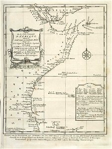
Map of part of the east coast of africa. Kaart van de oostkust van afrika, van den xiiie graad zuiderbreedte, tot den xvie graad noorderbreedte. Carte de la coste orientale d'afrique, depuis le xiiie degré de latitude merid: jusqu'au xvie degré de latitude septentr:
bottom right an explication of the abbreviations used. Date: 1747. Dimensions: height: 14.5 cm (5.7 in); width: 19.5 cm (7.6 in). Medium: engraving on paper. Collection: Koninklijke Bibliotheek. AMH-7925-KB Map of part of the east coast of Africa
Loading...