Log in
All resources
Create a design
27,441 Free Images of Maps
maps in the library of congress
joan blaeu
maps with figures
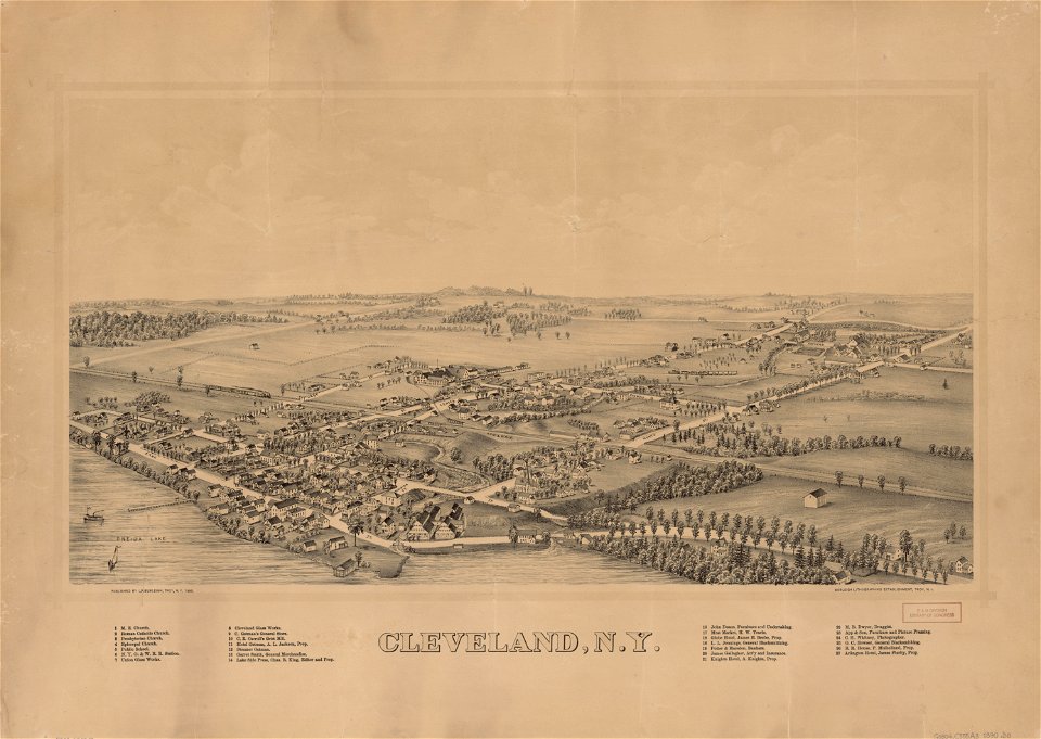
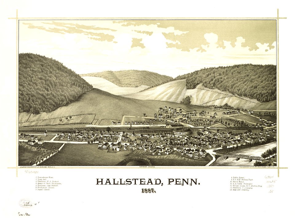
town maps by l. r. burleigh
l. r. burleigh
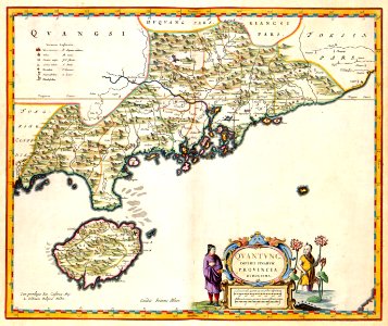
novus atlas sinensis
koninklijke bibliotheek
maps by willem and johannes blaeu
coats of arms on maps
latin-language maps
old county maps of middlesex
maps by thomas kitchin
maps by abraham ortelius
maps by jodocus hondius
charlotte brontë
branwell brontë
maps of the world with orthographic projection
maps of the world without antarctica
glaciers and glaciation (1910)
maps of yakutat bay
1890s maps of the united states
maps of the thousand islands
maps in the library of congress
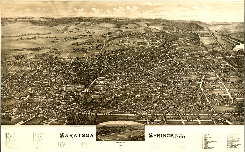
1891 maps of new york (state)
hendrik van langren map of south asia
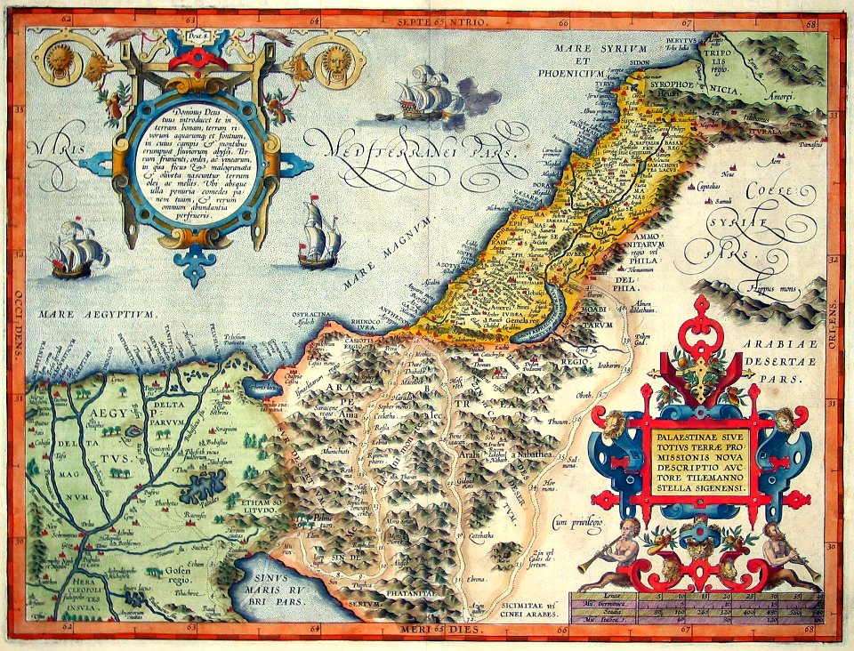
16th-century maps of the near east
maps in the library of congress
1890 maps of new york (state)
maps of saguaro national park
oro valley
maps of mars by the mars global surveyor moc
argyre planitia
maps in the library of congress
fort lyon (virginia)
maps in the staats- und universitätsbibliothek hamburg
daniel frese
maps in the library of congress
old maps of anniston, alabama
atlas van der hagen (volume 4)
atlas van der hagen
1650s maps of china
1655 maps of asia
maps in the library of congress
1655 maps of asia
maps by john cary
1799 maps
1770s maps of alaska
robert de vaugondy
impact craters on mars
gill (martian crater)
maps by girolamo porro
leonardo cernoti
maps of the duchy of courland and semigallia
old maps of livonia
maps by willem and johannes blaeu
maps by jodocus hondius
maps of the west-indische compagnie
1758 maps
maps in the library of congress
1888 maps of new york (state)
old maps of the sea of japan
rangaku
1860s maps of new york (state)
maps showing 1776
illustrations from claudius bombarnac by léon benett
1890s maps of china
carte de barbarie, nigritie, guinée par guillaume delisle (1707)
maps in the library of congress
19th-century maps of the black sea
g. h. swanston
historical maps of ethnic groups in romania
nouvelle géographie universelle
17th-century maps of the black sea
maps by willem and johannes blaeu
atlas van der hagen (volume 4)
atlas van der hagen
maps by thomas kitchin
andrew dury
maps in the library of congress
1885 maps of new york (state)
old maps of the south china sea
1680 maps of asia
turgot map of paris, kyoto university library – derivative files
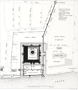
palais du louvre on old maps
maps of spain by tomas lopez
history of el bierzo
maps by willem and johannes blaeu
maps of the county of nice
maps in the library of congress
1887 maps of pennsylvania
maps in the library of congress
1883 maps of massachusetts
americae 1562 by diego gutiérrez and hieronymus cock
renaissance
churches in rome in art
renaissance
james bruce (explorer)
hiob ludolf
james bruce (explorer)
hiob ludolf
spanish-language maps
1780s maps of panama
old maps of the punjab region
old maps of uttarakhand
engravings of louvre by theodor hoffbauer
lithographs of paris
maps showing 19th-century history
19th-century maps of south asia
atlas van der hagen (volume 4)
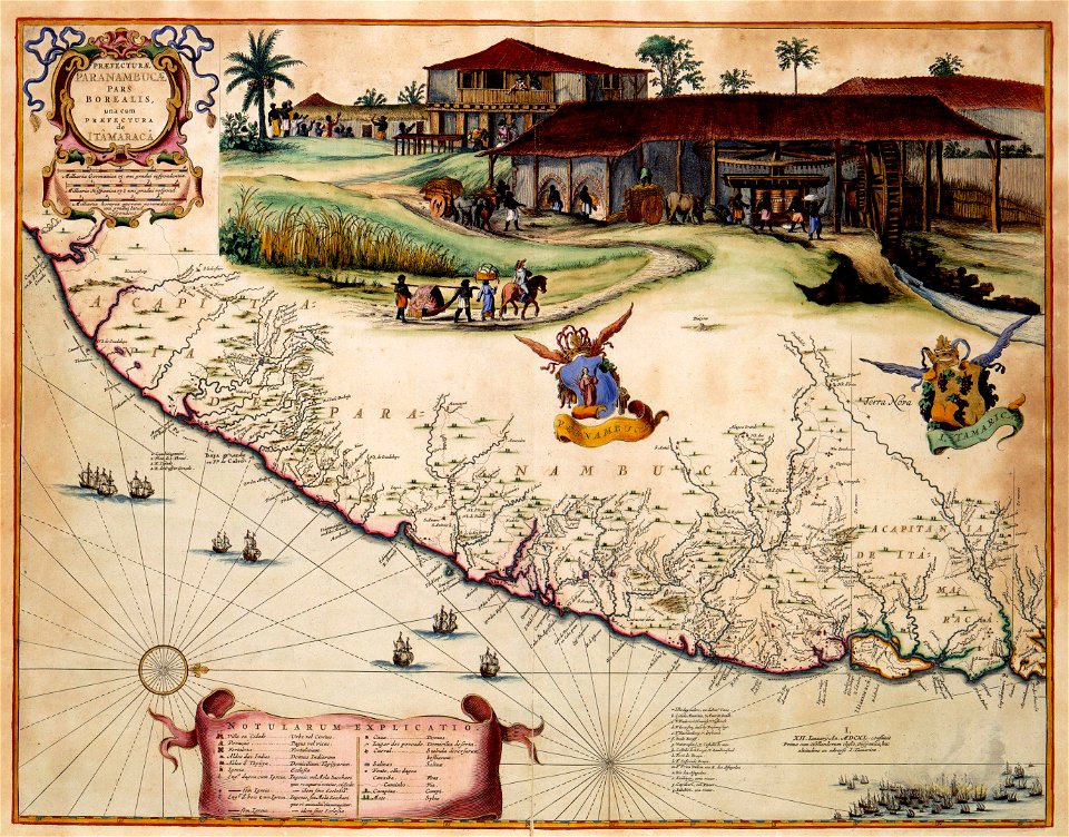
1660s maps of pernambuco
maps made in the 17th century
maps by jodocus hondius
map of europe by guillaume delisle (1700)
1789 maps of europe
danubius pannonico-mysicus
1720s maps of transylvania
1690s maps of eastern europe
maps by carolus allard
maps of the dutch east india company - sri lanka
maps of the dutch east india company - burma
a plan of the operations of the king's army under the command of general sr. william howe, k.b. in new york and east new jersey, against the american forces commanded by general washington, from the 12th. of october, to the 28th. of november 1776
old maps of new york (state) from the norman b. leventhal map center
old maps of haarlem
museum haarlem
atlas de jacoubet, bibliothèque historique de la ville de paris
collège stanislas (paris)
maps of san juan, puerto rico
san juan bay, puerto rico
st andrew's church (roman catholic, manhattan)
sanborn maps of manhattan published in 1905
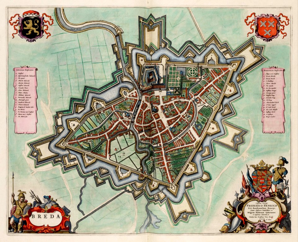
old maps of breda, netherlands
atlas van loon
atlas maior, vol 1 (northern europe, norway, and denmark) - joan blaeu, 1667 - bl 114.h(star).1
1667 maps
atlas maior, vol 11 (asia) - joan blaeu, 1667 - bl 114.h(star).11
1667 maps
jacques-nicolas bellin
1773 maps of africa
topographia austriacarum (merian)
baroque
personifications of england
augusto grossi
jaroslav zdeněk
josef farský
files based of data provided by the czech office for surveying and cadastre
maps of the franciscan cadaster of bohemia
hildesheim see coat of arms
coats of arms on maps
old cartoon maps of europe
1870 cartoons
latin-language maps
emery walker
1710s maps of moldova
daniel de la feuille
maps of ciudad colonial
caribbean sea in art
french-language maps from ios map collection
old maps of carinthia
maps in the library of congress
bird's eye view maps of alabama
maps by willem and johannes blaeu
old maps of upper lusatia
colonial history of the united states
old maps of new york (state)
maps by jodocus hondius
1595 maps
english-language maps
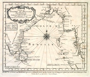
1747 maps of asia
media from the national library of finland
classicism
old maps of zhejiang
maps with cartouches
maps from traité de la police, bibliothèque nationale de france
second map of paris from traité de la police
1645 maps of belgium
tournaisis
old maps of french guiana
old maps of venezuela
navigantium atque itinerantium bibliotheca
18th-century maps of south asia
old maps of cities in texas
maps of fort worth, texas
old maps of rhineland-palatinate
old maps of alsace
maps by willem and johannes blaeu
old maps with mercator projection
old maps of venice
erhard reuwich
old maps of edinburgh
maps by john rocque
daniel de la feuille
1710 maps of africa
maps of paris from the david rumsey historical map collection
map of paris by jouvin de rochefort (boutier 133)
maps by peter lesley
maps by james hall
history of heilbad heiligenstadt
baroque
eran laor cartographic collection
cornelis van baarsel
maps of munich by braun & hogenberg
eran laor cartographic collection
old maps of gelderland
old maps of zutphen
old maps of barcelona
1806 maps of spain
the hague in the 1570s
siege of leiden
18th-century maps of the malay archipelago
18th-century maps of sulawesi
1101 - 1200 of 27,441
Next page
/ 275