Log in
All resources
Create a design
27,441 Free Images of Maps
bibliothèque nationale de france
eran laor cartographic collection
latin-language maps
maps by willem and johannes blaeu
richard william seale
theatri praecipvarvm totivs mvndi vrbivm : liber sextvs (1618)
national library of poland
maps in the library of congress
paper
british museum
atlas maior, vol 8 (france ii and switzerland) - joan blaeu, 1667 - bl 114.h(star).8
1667 maps
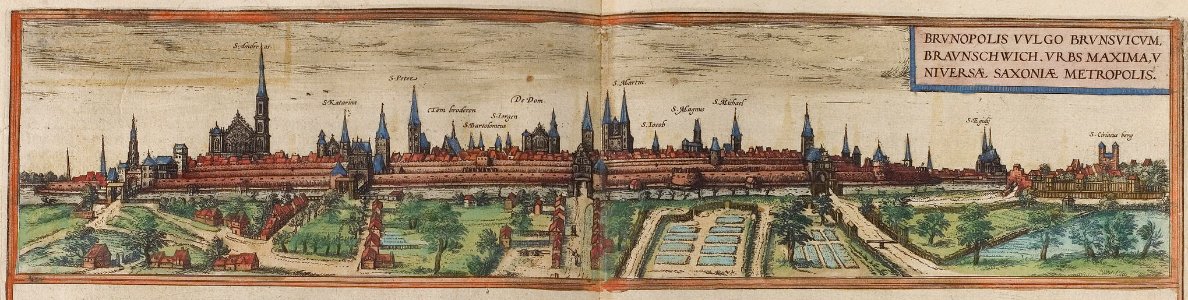
maps of braunschweig by braun & hogenberg
braunschweig
maps of linz by braun & hogenberg
linz
maps in the rijksmuseum amsterdam
17th-century maps of south asia
bibliothèque nationale de france
1667 sanson map of africa
bibliothèque nationale de france
1667 sanson map of africa
maps of the iberian peninsula by mercator-hondius
maps by pieter van der keere
town of bamberg (world heritage site)
maps of bamberg by braun & hogenberg
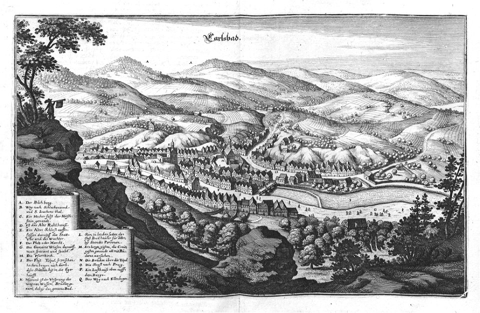
engravings of topographia bohemiae moraviae et silesiae
baroque
pierre i lepautre
claude perrault
maps in the rijksmuseum amsterdam
18th-century maps showing history
old submaps of paris 1er arrondissement
plans of the palais-royal
maps of mons (hainaut) by braun & hogenberg
city walls of arras
algeria in the 1880s
old maps of algeria
coats of arms of grand duchy of lithuania
magni ducatus lithuaniae
eran laor cartographic collection
richard william seale
eran laor cartographic collection
bernardino amico
eran laor cartographic collection
richard william seale
eran laor cartographic collection
philippe de la rué
eran laor cartographic collection
alexis-hubert jaillot
eran laor cartographic collection
johann ulrich krauß
eran laor cartographic collection
richard william seale
eran laor cartographic collection
jacob peeters
eran laor cartographic collection
richard william seale
georg balthasar probst (1732-1801)
eran laor cartographic collection
eran laor cartographic collection
johann ulrich krauß
a map of the valdichiana (rcin 912278)
high renaissance,renaissance
1750s portrait paintings from ireland
thomas hickey
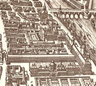
palais du louvre in the 1610s
palais du louvre on old maps
cosmographia (1588) by sebastian münster
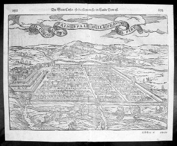
maps of cusco by braun & hogenberg
maps from the earth and its inhabitants, vol. xi
africa in the 1890s
gemeente atlas van nederland - south holland
old maps of gouda
18th-century maps of the dardanelles
1700s maps of turkey
maps in the library of congress
fidelity building (knoxville)
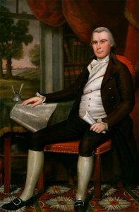
portrait paintings in the art institute of chicago
paintings by ralph earl
maps of abyssinia by mercator-hondius
historisk atlas (stockholm, norstedt & söner, 1880)
maps of 11th-century italy
curt teich postcard archives
map postcards
maps from the earth and its inhabitants, vol. x
19th-century maps of africa
matthäus merian der jüngere
great comet of 1680
maps from the mechanical curator collection
maps of regent's park
gemeente atlas van nederland - drenthe
maps of de wolden
maps of fortress of charlemont by braun & hogenberg
maps of givet and charlemont city walls
ceiling of the terrace of the geographical maps (uffizi gallery, florence)
ceiling of the terrace of the geographical maps (uffizi gallery, florence)
viktoriastraße (berlin-lichterfelde)
parts of old maps of berlin
prints by ambrogio brambilla
old maps of parma
ceiling of the terrace of the geographical maps (uffizi gallery, florence)
beschryving van 'sgraven-hage
the hague in the 1570s
military equipment of muscovite russia
details of sigismund's map of moscow
grenzkarte der preussischen, russischen und oestreichischen monarchien (1796)
maps of pomerania province
maps by pieter van der keere
old maps of friesland
theatri praecipvarvm totivs mvndi vrbivm : liber sextvs (1618)
maps of poznań by braun & hogenberg
mountains and lakes in cumberland and westmoreland (1808)
maps in the british museum
atlas vingboons
1665
maps in the library of congress
1790 maps
maps of ancient italy by philipp clüver
maps of samnium
theatri praecipvarvm totivs mvndi vrbivm : liber sextvs (1618)
maps of biecz by braun & hogenberg
mountains and lakes in cumberland and westmoreland (1808)
maps in the british museum
john rocque 1746 crops from library of congress
john rocque's maps of london
maps from gallica
old maps of rome
maps of the peloponnese by gerardus mercator
1640s maps of greece
old maps of bourbonnais
1660s maps of france
17th-century maps of savoie
old maps of savoie
17th-century maps of the netherlands
maps by pieter van der keere
old maps of antikythera
old maps of kythira
old maps of the shetland islands
old maps of the orkney islands
maps by hendrik hondius the younger
1632 maps of africa
theatri praecipvarvm totivs mvndi vrbivm : liber sextvs (1618)
maps of čáslav by braun & hogenberg
theatri praecipvarvm totivs mvndi vrbivm : liber sextvs (1618)
maps of eisenstadt by braun & hogenberg
maps by thomas starling
1842 maps
maps of blois by braun & hogenberg
urbanisation in loir-et-cher
maps of the islands of greece by marco boschini (1658)
old maps of lesbos
theatri praecipvarvm totivs mvndi vrbivm : liber sextvs (1618)
maps of dillenburg by braun & hogenberg
the new forest, its history and its scenery
symbolism
a.de la motraye's travels through europe, asia, and into part of africa (1723) by la mottraye
realism
the generall historie of virginia (john smith)
17th-century maps of virginia
gemeente atlas van nederland - groningen
maps of hoogezand
merian sueviae
baroque
eran laor cartographic collection
pierre françois tardieu
dominikanerkloster (frankfurt)
judengasse (frankfurt)
claes jansz. visscher (ii)
atlas van stolk
maps in the library of congress
emory place historic district
castles in landkreis biberach
uttenweiler
old maps of farmakonisi
old maps of agathonisi
maps by guillaume sanson
old maps of friesland
the british monarchy (1743)
maps in the british museum
maps by jean-baptiste bourguignon d'anville
1727 maps of africa
sanson maps of the netherlands
1680s maps of the netherlands
map of the upper rhenian circle by sanson
1670s maps of hesse
map of the upper rhenian circle by sanson
1700s maps of north rhine-westphalia
maps of the islands of greece by marco boschini (1658)
old maps of the peloponnese
maps of los palacios by braun & hogenberg
maps of las cabezas by braun & hogenberg
17th-century maps of the strait of magellan
1668 maps of south america
1780s maps of tunisia
1780s maps of libya
1698 map of evesché de meaux
robert cordier (engraver)
gemeente atlas van nederland - north holland
egmond-binnen
media contributed by university of illinois urbana-champaign university library
1631 maps of africa
geographia universalis (1545) in the british museum
german renaissance,northern renaissance
maps in the library of congress
1763 maps of north america
10501 - 10600 of 27,441
Next page
/ 275