Log in
All resources
Create a design
221 Free Images of 1850 Maps
maps by john tallis
bibliothèque nationale de france
maps in the rijksmuseum amsterdam
maps by john rapkin
shadows of the east; or, slight sketches of scenery, persons and customs, from observations during a tour in 1853 and 1854, in egypt, palestine, syria, turkey, and greece (1855) by tobin
published by frans buffa & zonen
chromolithographs in the rijksmuseum amsterdam
gezigten uit neerland's west-indien
english-language maps
maps of the dutch caribbean
history of visualization
dot maps
19th-century maps of tibet
1850s maps of china
17th-century maps of korea
1680s maps of china
robert wallis (engraver)
henry warren
portrait paintings by michele gordigiani
scapigliatura
1850s maps of ontario
maps by john tallis
robert wallis (engraver)
henry warren
maps by john tallis
maps by john rapkin
19th-century maps of china
richard jarman
1850s maps of the americas
maps by john tallis
karl ii zu schwarzenberg
eugen adam
old maps of prague
history of karlín
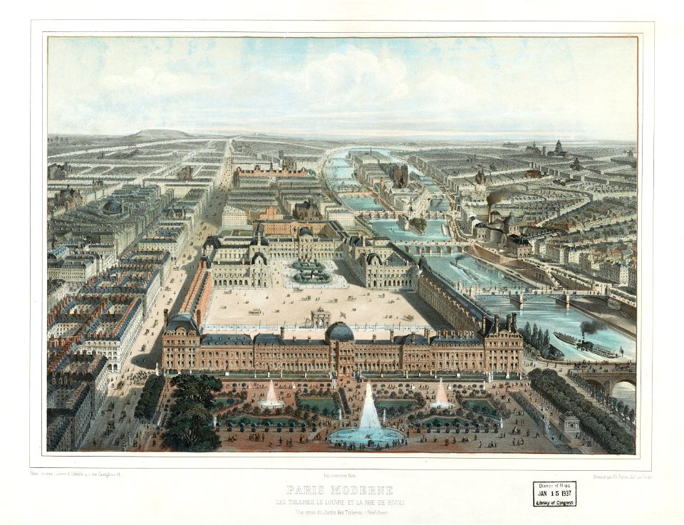
maps of paris from bibliothèque nationale de france
maps of paris in the 1850s
works of nathaniel dearborn
1850s maps of boston
maps of the great western railway
charles frederick cheffins
1849 maps of north america
old maps of canada
old rail transport maps of the united kingdom
charles frederick cheffins
1855 maps of the russian empire
1850s maps of crimea
landais & oberthur
maps from gallica
1857 maps of illinois
1850s maps of chicago
historical aerial views of the louvre
1850 in paris
vue (en relief et à vol d'oiseau) de paris by jacques-alphonse testard
maps of paris from bibliothèque nationale de france
racial type portraits
racial maps
maps from the mechanical curator collection
19th-century maps of the nile river
kanonenteich (leipzig)
adolf eltzner
london & birmingham railway
charles frederick cheffins
bibliothèque municipale de reims, chgg 9
maps of châlons-en-champagne
maps from the mechanical curator collection
1855 maps
old maps of visby
pehr arvid säve
1859 maps of hamburg
alster (river)
1858 van de velde maps of palestine and jerusalem
1850s maps of lebanon
panoramics in leipzig
adolf eltzner
19th-century maps of bohemia
maps of regions of bohemia
crystal palace in hyde park
victorian architecture
maps in the library of congress
1850 maps of new york (state)
victor levasseur - maps of the world
coats of arms of switzerland
voyage dans la russie méridionale et la crimée (1840-1842) par anatolii nikolaevich demidov
1853 maps of russia
joseph james forrester
alto douro vinhateiro
1858 van de velde maps of palestine and jerusalem
1850s maps of jerusalem
1851 maps of europe
edward lear
maps of hrodna by braun & hogenberg
historical images of hrodna
maps in the library of congress
augustus kollner
lawrence h. slaughter collection of english maps, charts, globes, books and atlases
nypl lionel pincus and princess firyal map division
eran laor cartographic collection
joseph schwarz
orientalist painting
old maps of dakar
1857 maps of illinois
1850s maps of chicago
old maps of the moon
johann georg heck
history of yokohama
maps of yokohama
old maps of leopoldstadt
old maps of brigittenau
maps in the rijksmuseum amsterdam
published by frans buffa & zonen
maps in the rijksmuseum amsterdam
published by frans buffa & zonen
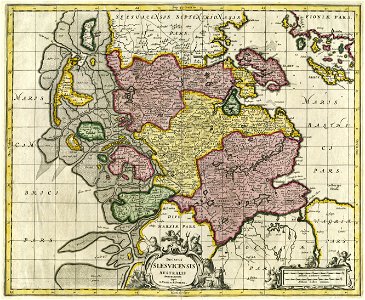
17th-century maps of schleswig-holstein
maps by pieter schenk (i)
maps of trenton, new jersey
gregory anthony perdicaris
gloucester, massachusetts, in the 19th century
massachusetts in the 1850s
victor levasseur - maps of the world
1850s maps of oceania
maps in the rijksmuseum amsterdam
published by frans buffa & zonen
1858 van de velde maps of palestine and jerusalem
eran laor cartographic collection
inspection générale des carrières
maps from gallica
shadows of the east; or, slight sketches of scenery, persons and customs, from observations during a tour in 1853 and 1854, in egypt, palestine, syria, turkey, and greece (1855) by tobin
1850s maps of palestine
shadows of the east; or, slight sketches of scenery, persons and customs, from observations during a tour in 1853 and 1854, in egypt, palestine, syria, turkey, and greece (1855) by tobin
1850s maps of palestine
maps in the rijksmuseum amsterdam
published by frans buffa & zonen
maps in the rijksmuseum amsterdam
published by frans buffa & zonen
bibliothèque municipale de reims, chgg 9
maps of châlons-en-champagne
eran laor cartographic collection
william hughes (geographer)
joseph lemercier
auguste logerot
manual of the corporation of the city of new york (1851)
maps from valentine's manual
prints in the british museum
charles baugniet
victor levasseur - maps of the world
french algeria
19th-century double hemisphere world maps
maps by alexandre vuillemin
18th-century maps of switzerland
daniel de la feuille
the comprehensive history of england (1876)
english-language maps showing history
old maps of genoa
nicolò armanino
arctic (ship, 1850)
ss arctic disaster
maps, prints and photographs in royal danish library
carl wilhelm wiehe
a & c black general atlas of the world
1850s maps of the world
eran laor cartographic collection
joseph schwarz
van de velde, 1857
gaza city in art
old maps of reims
ramparts of reims
lithographs in the rijksmuseum amsterdam
siege of 's-hertogenbosch
bibliothèque nationale de france
félix robaut
le sénégal. la france dans l'afrique occidentale (1889)
orientalist painting
lithographs in the british museum
jules géruzet
historical collections of the state of new jersey (1852)
1850s maps of new jersey
old maps of the nile delta
1850s maps of egypt
shadows of the east; or, slight sketches of scenery, persons and customs, from observations during a tour in 1853 and 1854, in egypt, palestine, syria, turkey, and greece (1855) by tobin
maps of upper egypt
incidents of travel in central america, chiapas, and yucatan (1858)
romanticism
maps in the rijksmuseum amsterdam
published by frans buffa & zonen
mountain height comparison diagrams
andriveau-goujon
manual of the corporation of the city of new york (1857)
1857 books
nineveh and babylon - a narrative of a second expedition to assyria during the years 1849, 1850, and 1851 (1882)
maps of babylon
nineveh and babylon - a narrative of a second expedition to assyria during the years 1849, 1850, and 1851 (1882)
maps of babylon
nineveh and babylon - a narrative of a second expedition to assyria during the years 1849, 1850, and 1851 (1882)
maps of nimrud
historical collections of the state of new jersey (1852)
1850s maps of new jersey
internet archive document dayswaysinoldbos00ross 0
days and ways in old boston (1915)
bibliothèque nationale de france
félix robaut
lithographs in the british museum
henry wyndham phillips
1100 block of royal street, french quarter
1885 in new orleans
tsūzoku suikoden gōketsu 108 nin no uchi (108 heroes of the popular water margin) by utagawa kuniyoshi
ukiyo-e
lithographs in the british museum
lemercier & cie.
recuerdos y bellezas de españa. reino de granada (1850)
maps of alhambra
1 - 100 of 221
Next page
/ 3