Log in
All resources
Create a design
58 Free Artworks of Old Maps Of New France
bibliothèque nationale de france
adriaen van der donck
maps made in the 17th century
1685 maps
maps of new england
old maps of new york (state)
maps of the hudson river
maps of nieuw nederland
new amsterdam
novi belgii, atlas maior
maps in the library of congress
adriaen van der donck
maps made in the 17th century
adriaen van der donck
1900 maps of russia
1900 maps of china
maps in the library of congress
adriaen van der donck
maps in the library of congress
adriaen van der donck
history of antwerp
renaissance
maps of the west-indische compagnie
1800 maps of the united states
maps in the library of congress
adriaen van der donck
maps in the library of congress
adriaen van der donck
lawrence h. slaughter collection of english maps, charts, globes, books and atlases
maps of nieuw nederland
1560s maps of north america
paolo forlani
a set of fifty new and correct maps of england and wales
old county maps of northamptonshire
maps by john cary
1799 maps
17th-century maps of asia
maps from gallica
maps by jacques-nicolas bellin
old maps of new france
maps by louis brion de la tour
french-language maps
maps of paris from bibliothèque nationale de france
maps of paris by louis-joseph mondhare
1777 maps of new york (state)
1777 maps of new jersey
maps of paris from bibliothèque nationale de france
maps of paris by louis-joseph mondhare
19th-century maps of bohemia
19th-century maps of silesia
1645 maps of belgium
tournaisis
landais & oberthur
maps from gallica
18th-century maps of north america
1708 maps of north america
old maps of bouvet island
bouvet island
maps of paris from bibliothèque nationale de france
nouveau plan de paris by louis brion de la tour
maps with cartouches
old maps of yunnan
1762 maps of north america
maps by tomas lopez
maps of paris from bibliothèque nationale de france
nouveau plan de paris by louis brion de la tour
maps of paris from bibliothèque nationale de france
nouveau plan de paris by louis brion de la tour
old maps of the bahamas
lucayas
old maps of périgueux
1660s maps of france
old maps of henan
maps with figures
old county maps of hertfordshire
maps by thomas kitchin
maps by alexis-hubert jaillot
maps by guillaume sanson
mainz in the 1730s
old maps of mainz
old maps of new france
1663 maps
1750s maps of central america
maps by tomas lopez
old maps of the viceroyalty of new spain
1570s maps of mexico
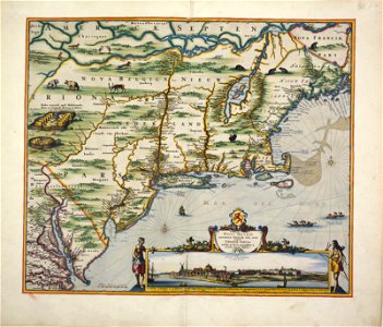
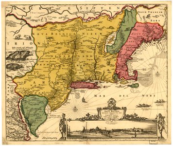
old maps of nova belgica et anglia nova
maps by willem and johannes blaeu
maps in the library of congress
1744 maps
old county maps of hertfordshire
maps by thomas kitchin
maps by thomas kitchin
old maps of scotland
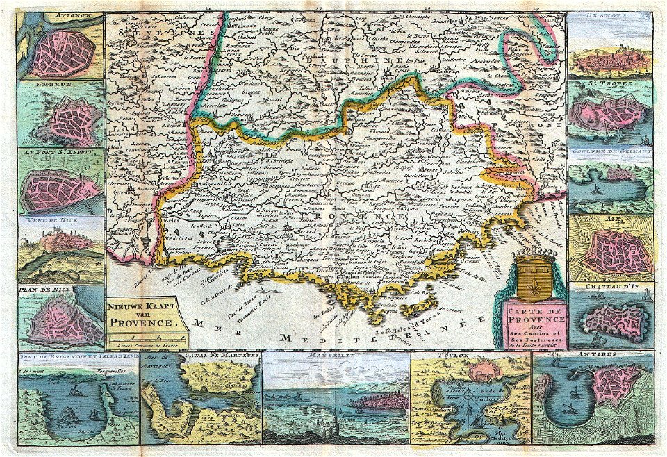
old maps of provence
1747 maps of france
maps of neuf-brisach city walls
leonhard christoph sturm
henri le roy (1579-)
diocese of aire
old maps of swabia
maps by john cary
old maps of northumberland
maps by thomas kitchin
maps by thomas kitchin
old maps of hampshire
old maps of oxfordshire
maps by thomas kitchin
considérations géographiques et physiques sur les nouvelles découvertes au nord de la grande mer
1750s maps of the russian empire
maps of paris from the david rumsey historical map collection
maps of île-de-france by françois de la guillotière
atlas, ou représentation du monde universel et des parties d'icelui, faicte en tables et descriptions très amples et exactes, divisé en deux tomes. édition nouvelle... - btv1b53103889w
maps facing west
napoleon i of france in art
academic art
old maps of the american civil war
1861 maps
considérations géographiques et physiques sur les nouvelles découvertes au nord de la grande mer
old maps of the yellow sea
old maps of mainz
baroque
maps of the captaincy general of cuba
maps of the history of florida
old maps of the viceroyalty of new spain
the spanish borderlands
1 - 58 of 58
/ 1