Log in
All resources
Create a design
74 Free Artworks of Maps Of New Jersey
maps in the library of congress
claude joseph sauthier
historical collections of the state of new jersey (1852)
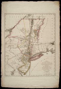
a map of the provinces of new york and new jersey, with a part of pennsylvania and the province of quebec
maps by claude joseph sauthier
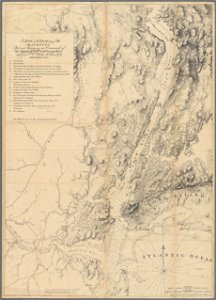
a plan of the operations of the king's army under the command of general sr. william howe, k.b. in new york and east new jersey, against the american forces commanded by general washington, from the 12th. of october, to the 28th. of november 1776
maps of the new york and new jersey campaign
george hayward
historical collections of the state of new jersey (1845)
maps from valentine's manual
1639 maps
1670 maps
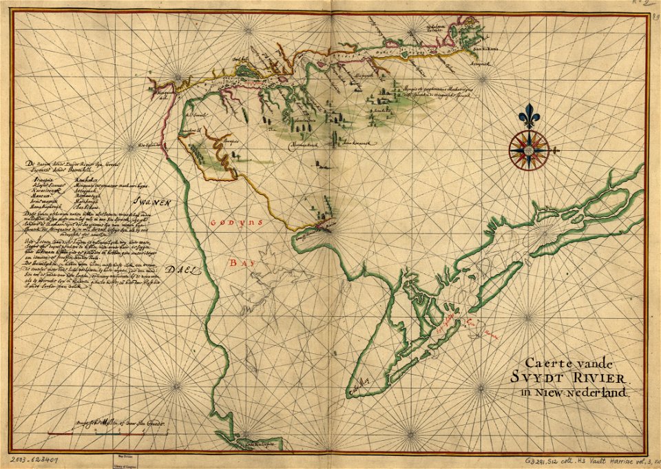
novi belgii, atlas maior
new netherland
city investing building
astor house building
west-indische compagnie
image restoration
maps by willem and johannes blaeu
hudson valley
a plan of the operations of the king's army under the command of general sr. william howe, k.b. in new york and east new jersey, against the american forces commanded by general washington, from the 12th. of october, to the 28th. of november 1776
old maps of new york (state) from the norman b. leventhal map center
maps by willem and johannes blaeu
new amsterdam
1860s maps of new york (state)
maps showing 1776
a plan of the operations of the king's army under the command of general sr. william howe, k.b. in new york and east new jersey, against the american forces commanded by general washington, from the 12th. of october, to the 28th. of november 1776
battle of white plains
19th-century maps of new jersey
maps of the delaware river
1777 maps of new york (state)
1777 maps of new jersey
maps of trenton, new jersey
gregory anthony perdicaris
1747 maps of new hampshire
english-language maps
maps in the library of congress
1747 maps of new jersey
manual of the corporation of the city of new york (1864)
maps showing 1776
maps of the new york and new jersey campaign
maps showing 1776
a map of the provinces of new york and new jersey, with a part of pennsylvania and the province of quebec
maps in the library of congress
maps in the library of congress
1776 maps of new jersey
a map of the provinces of new york and new jersey, with a part of pennsylvania and the province of quebec
lawrence h. slaughter collection of english maps, charts, globes, books and atlases
a map of the provinces of new york and new jersey, with a part of pennsylvania and the province of quebec
lawrence h. slaughter collection of english maps, charts, globes, books and atlases
a map of the provinces of new york and new jersey, with a part of pennsylvania and the province of quebec
lawrence h. slaughter collection of english maps, charts, globes, books and atlases
historical collections of the state of new jersey (1845)
maps facing west
a map of the provinces of new york and new jersey, with a part of pennsylvania and the province of quebec
maps in the library of congress
manual of the corporation of the city of new york (1858)
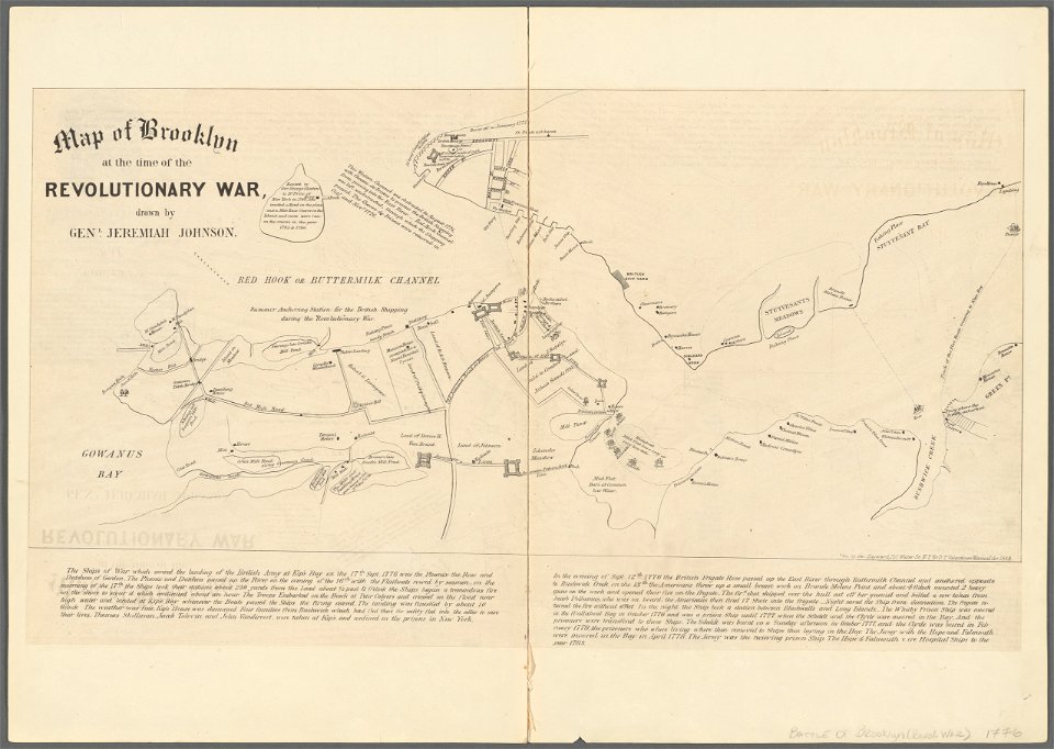
battle of long island
historical collections of the state of new jersey (1852)
1850s maps of new jersey
maps of the west-indische compagnie
maps by claude joseph sauthier
a plan of the operations of the king's army under the command of general sr. william howe, k.b. in new york and east new jersey, against the american forces commanded by general washington, from the 12th. of october, to the 28th. of november 1776
iona island (new york)
lawrence h. slaughter collection of english maps, charts, globes, books and atlases
de nieuwe en onbekende weereld
historical collections of the state of new jersey (1852)
1850s maps of new jersey
a map of the provinces of new york and new jersey, with a part of pennsylvania and the province of quebec
maps in the library of congress
a map of the provinces of new york and new jersey, with a part of pennsylvania and the province of quebec
lawrence h. slaughter collection of english maps, charts, globes, books and atlases
manual of the corporation of the city of new york (1858)
battle of long island
1670s maps of new york (state)
1670s maps of new jersey
a map of the provinces of new york and new jersey, with a part of pennsylvania and the province of quebec
historical collections of the state of new jersey (1845)
maps of newark, new jersey
18th-century maps of north america
1708 maps of north america
stony brook, new jersey
battle of princeton
maps in the library of congress
1776 maps of new jersey
maps in the library of congress
1778 maps of new jersey
historical collections of the state of new jersey (1852)
maps of newark, new jersey
burlington, new jersey in the 18th century
maps of burlington, new jersey
maps in the library of congress
old maps of new jersey
historical collections of the state of new jersey (1852)
maps of trenton, new jersey
historical collections of the state of new jersey (1868)
1860s maps of new jersey
historical collections of the state of new jersey (1845)
maps of burlington, new jersey
new york and brooklyn, with jersey city and hoboken water front
maps in the library of congress
new york and brooklyn, with jersey city and hoboken water front
maps in the library of congress
buildings in trenton, new jersey
prisons in new jersey
old maps of manhattan, new york city
croton aqueduct
a map of the provinces of new york and new jersey, with a part of pennsylvania and the province of quebec
maps in the library of congress
colonial history of the united states
old maps of new york (state)
maps of newark, new jersey
hudson river school
maps of newark, new jersey
hudson river school
maps of newark, new jersey
hudson river school
historical collections of the state of new jersey (1852)
prisons in new jersey
maps in the library of congress
1776 maps of new jersey
historical collections of the state of new jersey (1852)
1850s maps of new jersey
maps in the library of congress
1776 maps of new jersey
new york and brooklyn, with jersey city and hoboken water front
maps in the library of congress
zehn karten und ansichten den schlachtfelden des amerikanischen unabhängigkeitskreiges in den staaten pennsylvanien und new york
maps in the library of congress
1806 maps of the united states
maps by john cary
historical collections of the state of new jersey (1852)
1852 maps of the united states
historical collections of the state of new jersey (1852)
stony brook, new jersey
maps in the library of congress
augustus kollner
maps in the library of congress
old maps of new jersey
a plan of the operations of the king's army under the command of general sr. william howe, k.b. in new york and east new jersey, against the american forces commanded by general washington, from the 12th. of october, to the 28th. of november 1776
maps in the library of congress
historical collections of the state of new jersey (1852)
a plan of the operations of the king's army under the command of general sr. william howe, k.b. in new york and east new jersey, against the american forces commanded by general washington, from the 12th. of october, to the 28th. of november 1776
german-language maps
west-indische compagnie
image restoration
1821 maps of the united states
maps by john cary
1823 maps of new york city
circular maps
1690s maps of the caribbean
1690s maps of the americas
1860 valentine map of new york city
george hayward
a plan of the operations of the king's army under the command of general sr. william howe, k.b. in new york and east new jersey, against the american forces commanded by general washington, from the 12th. of october, to the 28th. of november 1776
maps in the library of congress
1 - 74 of 74
/ 1