Map of British Military Operations in New York and New Jersey in 1776 (6 MB), George Hayward, 1864

Map of British Military Operations in New York and New Jersey in 1776 (6 MB), George Hayward, 1864

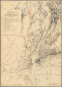
Title: a sketch of the operations of his majesty's fleet and army under the command of right honorable lord viscount howe and general sir william howe, k. B. In 1776. Lower left says: "communicated for the manual by george h. Moore, librarian of the new-york historical society. " lower left corner says: "copied from the original by g. Hayward 171 pearl st. N. Y. For d. T. Valentine's manual 1864. " lower right corner says: "published according to act of parliament january 17th 1777 by j. F. W. Des barres esq. " from: valentine, d. T. , ed. (1864) manual of the corporation of the city of new york, new york city: common council, pp. 668–69 (in between); map key 669–71 [aka valentine's manual (1864)]. Date: 1864.
Edit image
Published by:
Creazilla
Author: Joseph Frederick Wallet DesBarres, cartographerGeorge Hayward, lithographerSource: commons.wikimedia.org

Loading...

0 downloads
Loading...
maps showing 1776manual of the corporation of the city of new york (1864)maps from valentine's manualjoseph frederick wallet desbarresmaps of the new york and new jersey campaigngeorge hayward1860s maps of new york (state)1860s maps of new jersey

MORE LIKE THIS

Creazilla logo
Over 10 million free graphic resources for content creators and designers.
© 2018 - 2025 Creazilla
Our resourcesAll imagesPhotosDigital illustrationsClipartIconsPNG ImagesEmojisSilhouettesTraditional Art3D ModelsVectorsFontsColor namesColor palettesGradientsAudioAnimationVideosTemplates
InformationAbout CreazillaTerms of useTech teamPrivacy policyLicence Information
FeedbackContact Us