Map of Brooklyn and Lower Manhattan in September 1776 (4 MB), George Hayward, published in 1858

Map of Brooklyn and Lower Manhattan in September 1776 (4 MB), George Hayward, published in 1858

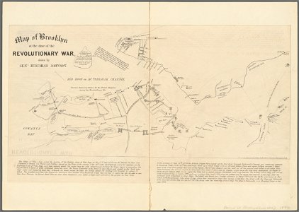
Map of brooklyn at the time of the revolutionary war, drawn by general jeremiah johnson from: valentine, d. T. , ed. (1858) manual of the corporation of the city of new york, new york city: common council, between pp. 112 and 113 [aka valentine's manual (1858)]. Date: published in 1858.
Edit image
Published by:
Creazilla
Author: George Hayward, lithographerSource: commons.wikimedia.org

Loading...

0 downloads
Loading...
battle of long islandmanual of the corporation of the city of new york (1858)maps from valentine's manualold maps of lower manhattanold maps of brooklyn, new york citygeorge hayward1776 maps of new york (state)1770s maps of new york citymaps of the new york and new jersey campaign

MORE LIKE THIS

Creazilla logo
Over 10 million free graphic resources for content creators and designers.
© 2018 - 2025 Creazilla
Our resourcesAll imagesPhotosDigital illustrationsClipartIconsPNG ImagesEmojisSilhouettesTraditional Art3D ModelsVectorsFontsColor namesColor palettesGradientsAudioAnimationVideosTemplates
InformationAbout CreazillaTerms of useTech teamPrivacy policyLicence Information
FeedbackContact Us