Log in
All resources
Create a design
26,489 Free Artworks of Map
bibliothèque nationale de france
eran laor cartographic collection
maps by willem and johannes blaeu
turgot map of paris, kyoto university library – derivative files
baroque
matthäus merian
paper
british museum
french-language maps
maps by pieter mortier
eran laor cartographic collection
caspar merian
map of bruges by marcus gheeraerts (i)
engravings
maps of lappland
1662
map of paris by claes jansz. visscher - derivate files
17th-century people of paris
hamburgische elbkarte von melchior lorichs
parts of old maps of hamburg
ptolemy maps by gerardus mercator
franciscus halma
maps by pieter mortier
old maps of rovigo
maps of paris by braun & hogenberg
maps of paris from paris musées
hamburgische elbkarte von melchior lorichs
old maps of ritzebüttel
hôtel de guénégaud (quai de nevers)
collège des quatre-nations
maps of roanoke island
theodor de bry
maps in the library of congress
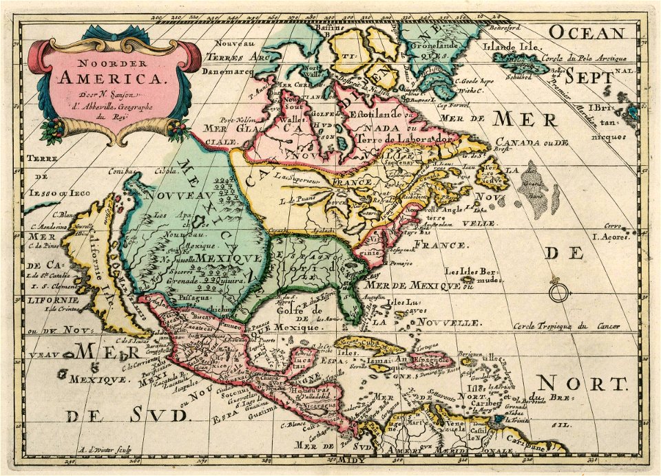
1752 maps of north america
lithographs of paris
floor plans of paris
paintings in private collections
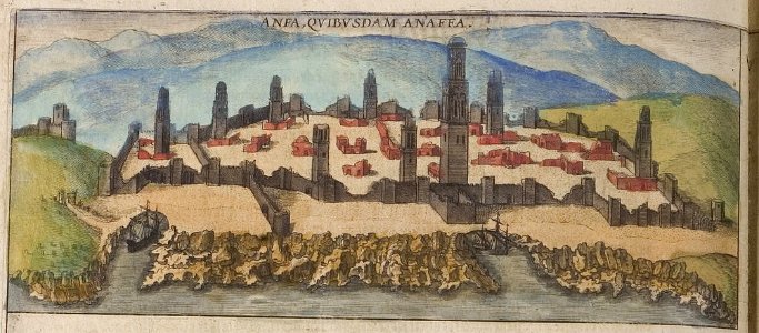
1570s engravings
eran laor cartographic collection
philippe de la rué
gemeente atlas van nederland - north holland
19th-century maps of amsterdam
historical images of île de la barthelasse
villeneuve-lès-avignon
eran laor cartographic collection
nicolas langlois
map of the circle of austria by sanson
1700s maps of austria
maps in the library of congress
old maps of latin america
map of the circle of the rhineland by sanson
1730s maps of rhineland-palatinate
maps of wissembourg by braun & hogenberg
maps of rouffach by braun & hogenberg
maps of casablanca by braun & hogenberg
casablanca
fourth and gill historic district
maps in the library of congress
city walls of lechenich
baroque
yokohama foreign settlement
history of yokohama
surveying in the united states
1854 maps of california
dripps maps of manhattan published in 1867
neoclassicism
maps of utrecht (city) city walls
old maps of utrecht (city)
atlas maior, vol 10 (spain and africa) - joan blaeu, 1667 - bl 114.h(star).10
1667 maps
avignon in the 17th century
atlas van loon
maps of 's-hertogenbosch by braun & hogenberg
maps by willem and johannes blaeu
maps by willem and johannes blaeu
1662 maps of norway
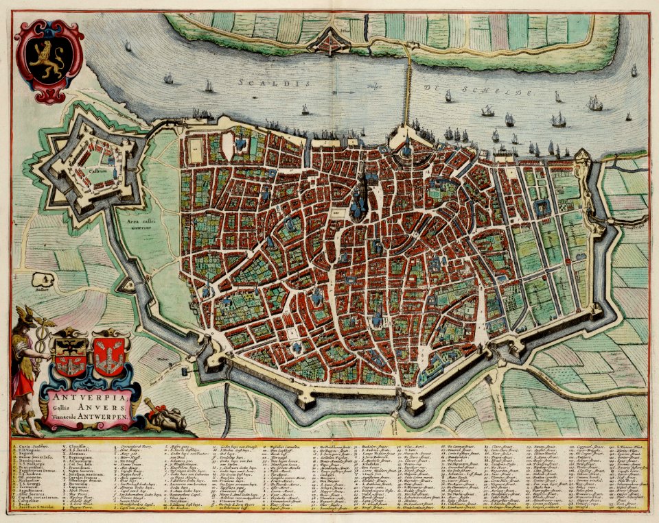
johannes blaeu - map of antwerp
atlas van loon
prints by agostino veneziano
old maps of tunis
files based of data provided by the czech office for surveying and cadastre
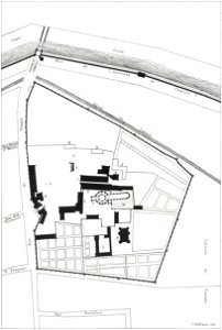
kačina
turgot map of paris, kyoto university library – derivative files
hôtel d'aumont
die grund-regeln der bau-kunst
old maps of southeast asia
turgot map of paris, kyoto university library – derivative files
hôtel de brionne
maps of the world without antarctica
film locations of star wars
turgot map of paris, kyoto university library – derivative files
hôtel de matignon
lawrence h. slaughter collection of english maps, charts, globes, books and atlases
1700 maps of the atlantic ocean
lawrence h. slaughter collection of english maps, charts, globes, books and atlases
1700 maps of the atlantic ocean
geographia universalis (1545) in the british museum
german renaissance,northern renaissance
old county maps of hertfordshire
maps by thomas kitchin
geographia universalis (1545) in the british museum
german renaissance,northern renaissance
geographia universalis (1545) in the british museum
german renaissance,northern renaissance
extra-ptolemaic maps of the americas (1540 design by münster)
german renaissance,northern renaissance
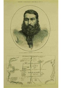
abdur rahman khan in art
thomas dewell scott
eran laor cartographic collection
tranquillo mollo
eran laor cartographic collection
joseph roux
hamburg in topographia saxoniae inferioris (merian)
baroque
eran laor cartographic collection
tranquillo mollo
eran laor cartographic collection
jaspar isaac
the hague in the 1720s
old maps of the hague
eran laor cartographic collection
guillaume sanson
mauritshuis in the 17th century
dutch baroque architecture
admiralty charts 2601-2800
tralee
turgot map of paris, kyoto university library – derivative files
foire saint-laurent
maps by willem and johannes blaeu
maps of rügen by eilhard lubinus
maps of dunkerque by braun & hogenberg
maps of bourbourg by braun & hogenberg
maps from gallica
baroque
maps by willem and johannes blaeu
old maps of dendermonde
galleria delle carte geografiche - ceiling
paintings of saint paul
maps from the earth and its inhabitants, vol. xiv
maps of the southern ocean
maps from the earth and its inhabitants, vol. x
maps with nicolosi globular projection
old maps of the sinai peninsula
1840s maps of arabia
maps in the rijksmuseum amsterdam
maps by pieter mortier
maps of the west-indische compagnie
1705
maps in the library of congress
plan de roussel
venezuela cum parte australi novae andalusiae - btv1b8596473x
maps by hendrik hondius the younger
old maps of périgueux
1660s maps of france
eran laor cartographic collection
isaak tirion
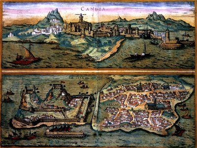
old maps of heraklion
baroque
eran laor cartographic collection
emanuel bowen
hôtel de choiseul (rue de richelieu)
salle favart i
maps of emden by braun & hogenberg
1575 in lower saxony
maps in the british museum
jan baptist berterham
old maps of westphalia
johannes gigas
panoramic maps of seville by braun & hogenberg
1635 in andalusia
atlas maior, vol 2 (sweden, russia, poland, eastern europe, and greece) - joan blaeu, 1667 - bl 114.h(star).2
17th-century maps of scandinavia
maps from the earth and its inhabitants, vol. iii
mining in austria
tian shan
alps
maps from the earth and its inhabitants, vol. xviii
colonialism
1590s maps of the world
cornelis de jode
moluccas in the 17th century
asia noviter delineata
maps from the earth and its inhabitants, vol. iv
brentford, england
old maps of delft
atlas van loon
old maps of verona
adriano cristofali
demolished churches in de barbari map
san stin (venice)
gemeente atlas van nederland - drenthe
maps of borger-odoorn
1800s maps of the netherlands
evert maaskamp
cartouches by tomas lópez
tomás lópez
maps of liège by johannes blaeu - derivative files
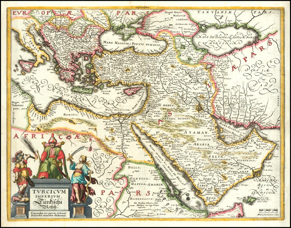
17th-century maps of the near east
baroque
the war between the united states and mexico illustrated
maps of the mexican-american war
hôtel de guénégaud (quai de nevers)
collège des quatre-nations
map of amsterdam by gerrit de broen (ii)
frederik willem greebe
maps by willem and johannes blaeu
17th-century maps of the world
media from regionaal archief alkmaar
schermerhorn
6701 - 6800 of 26,489
Next page
/ 265