Map of North and Central America, circa 1705

Map of North and Central America, circa 1705

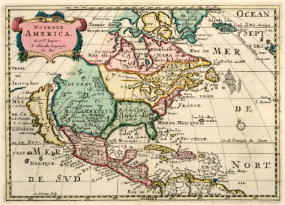
Map of north and central america. Noorder america. Although nieuw amsterdam had already passed into british hands in 1664, on this chart the city is indicated by both its old name (nieuw amsterdam) and its new name (new york). Date: circa 1705. Dimensions: height: 20.5 cm (8 in); width: 28.5 cm (11.2 in). Medium: coloured engraving on paper. Collection: Koninklijke Bibliotheek.
Edit image
Published by:
Creazilla
Author: Nicolas SansonSource: commons.wikimedia.org

Loading...

0 downloads
Loading...
maps of the west-indische compagnie1705anthonie de wintercoloured engraving on paperkoninklijke bibliotheek

MORE LIKE THIS

Creazilla logo
Over 10 million free graphic resources for content creators and designers.
© 2018 - 2025 Creazilla
Our resourcesAll imagesPhotosDigital illustrationsClipartIconsPNG ImagesEmojisSilhouettesTraditional Art3D ModelsVectorsFontsColor namesColor palettesGradientsAudioAnimationVideosTemplates
InformationAbout CreazillaTerms of useTech teamPrivacy policyLicence Information
FeedbackContact Us