Log in
All resources
Create a design
26,489 Free Artworks of Map
bibliothèque nationale de france
maps from the earth and its inhabitants, vol. x
maps in the library of congress
maps by willem and johannes blaeu
beschreibung der städt der welt - braun & hogenberg - btv1b52512111k
joan blaeu
atlas van loon
maps by gerard valck
gerard valck
maps from the mechanical curator collection
maps from the earth and its inhabitants, vol. x
1890 maps of africa
maps from the earth and its inhabitants, vol. xii
africa in the 1890s
20th-century maps of battles
battle of mondovi
maps of paris by braun & hogenberg
maps of paris from paris musées
gemeente atlas van nederland - south holland
maps of zuid-beijerland
maps of barbary coast by mercator-hondius
conquest of majorca
glaciers and glaciation (1910)
maps of glaciers of alaska
maps of the land of valkenburg
guillaume sanson
robert cordier (engraver)
maps by guillaume sanson
maps by pieter mortier
maps from gallica
landais & oberthur
maps from gallica
18th-century maps of veneto
1700s maps of slovenia
maps of the land of valkenburg
guillaume sanson
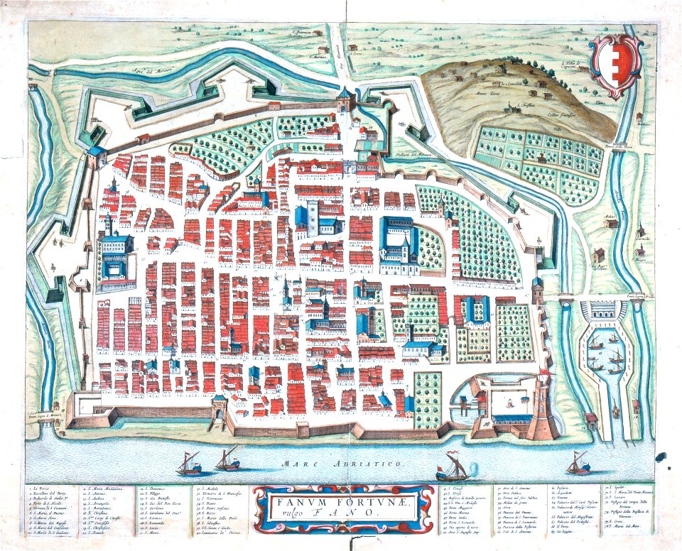
maps in the biblioteca federiciana
old maps of fano
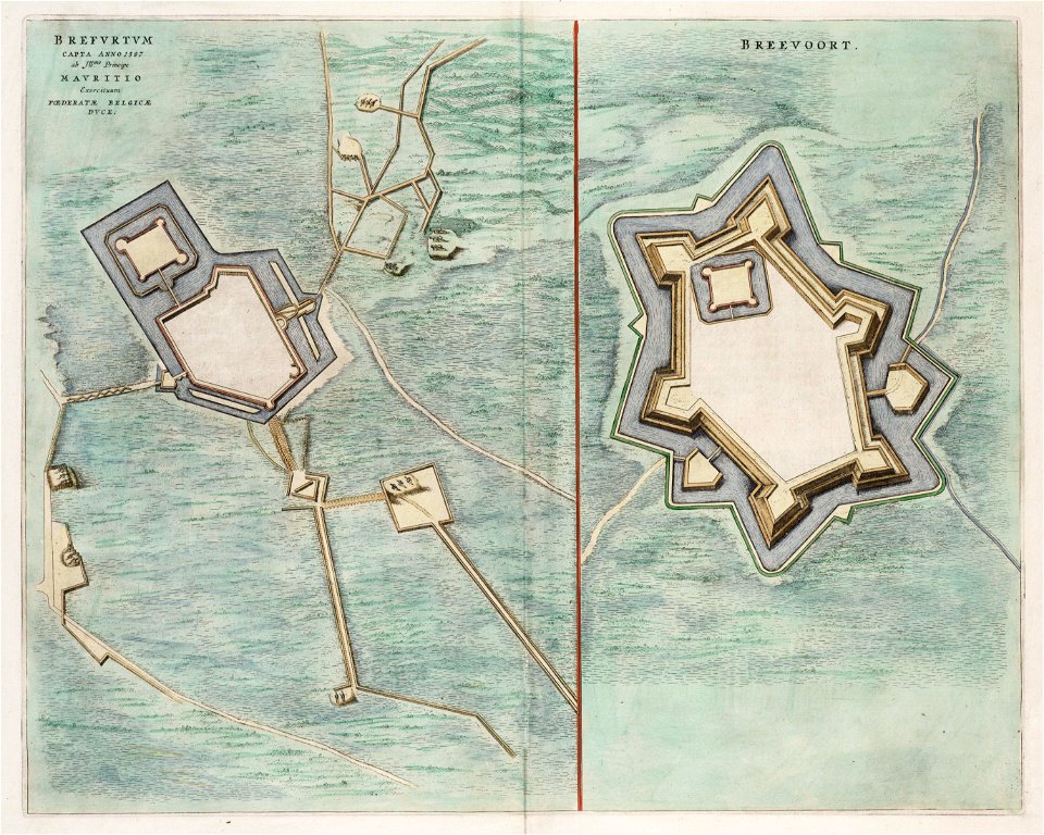
siege of bredevoort 1597
1597
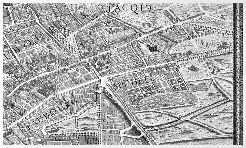
turgot map of paris, david rumsey historical map collection – derivative files
église sainte-marguerite (paris)
turgot map of paris, kyoto university library
proletarian literature
siberia and the exile system (1891)
maps of zabaykalsky krai
e. a. wallis budge
1920 maps
maps in the library of congress
18th-century maps of sumatra
maps of london by john norden (1593)
maps by pieter van der keere
history of alphen aan den rijn
maps of aarlanderveen
maps from the mechanical curator collection
australia (1873) by booth
description de l'universe
old maps of andros
lawrence h. slaughter collection of english maps, charts, globes, books and atlases
novi belgii, atlas maior
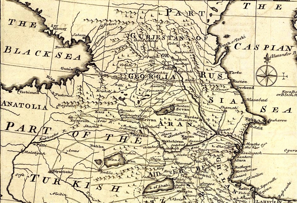
1747 persia map by emanuel bowen
details of old maps
1747 persia map by emanuel bowen
details of old maps
turgot map of paris, kyoto university library – derivative files
foire saint-germain on old maps
details of old maps of the united kingdom
cartouches by sanson family
maps of the land of oz
1914 maps
maps of the dutch east india company - indonesia
18th-century maps of borneo
maps of cities by vincenzo coronelli
old maps of livorno
maps in the library of congress
1849 maps
atlas van der hagen (volume 2)
atlas van der hagen
maps of košice by braun & hogenberg
1617 in hungary
map of ghent by hadrianus barlandus
map of ghent by hadrianus barlandus
nicolas desmarest
ambroise tardieu
old maps of the principality of minden
1840s maps of north rhine-westphalia
africa and its inhabitants, vol. ii
charles eugène perron
friedrich wilhelm delkeskamp
old maps of the rhineland
engravings by matthäus merian
baroque
walter riemer (illustrator)
1935 maps of germany
maps of 12th-century asia
maps of the crusades
maps from the earth and its inhabitants, vol. x
19th-century maps of africa
maps from the earth and its inhabitants, vol. x
19th-century maps of africa
curt teich postcard archives
map postcards
cartouches by sanson family
old maps of atlantis
ackermann's repository of arts/series 1/volume 01
1809 maps of the russian empire
svg maps of fictional places or locations
maps of the land of oz
maps from the earth and its inhabitants, vol. x
19th-century maps of africa
topographischer atlas der schweiz
old maps of fribourg
johann heinrich schmidt (fornaro)
baroque
17th-century maps of france
loudun (territorio)
beschreibung und contrafactur der vornembster stät der welt, liber primus civitates orbis terrarum
panoramic maps of seville by braun & hogenberg
beschreibung der städt der welt - braun & hogenberg - btv1b52512111k
maps of tunis by braun & hogenberg
beschreibung der städt der welt - braun & hogenberg - btv1b52512111k
maps of 's-hertogenbosch by braun & hogenberg
beschreibung der städt der welt - braun & hogenberg - btv1b52512111k
maps of münster (westfalen) by braun & hogenberg
maps by willem and johannes blaeu
1640 maps of africa
maps from the mechanical curator collection available to georeference
maps from the mechanical curator collection
beschreibung der städt der welt - braun & hogenberg - btv1b52512111k
panoramic maps of seville by braun & hogenberg
old and new london, illustrated (1873) by walter thornbury and edward walford - bl 1887 copy
maps from the mechanical curator collection
peregrinatio in terram sanctam (reuwich, 1486, latin)
1486 illustrations
dutch 17th-century prints in the rijksmuseum amsterdam
siege of moers 1597
maps in the library of congress
1750s maps of the caribbean
maps from the earth and its inhabitants, vol. iv
halifax, yorkshire
engravings by matthäus merian
baroque
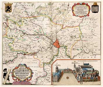
maps of the duchy of berg
maps by gerard valck
maps of paris by braun & hogenberg
maps of paris from paris musées
maps in the library of congress
1769 maps of europe
maps by willem and johannes blaeu
maps of montfoort
maps of valenciennes city walls
old maps of valenciennes
french renaissance
kartli
kingdom of bohemia (1627-1740)
17th-century maps of bohemia
eran laor cartographic collection
thesaurus philopoliticus
maps of liège by johannes blaeu - derivative files
palais curtius
atlas maior, vol 12 (america) - joan blaeu, 1667 - bl 114.h(star).12
1667 maps
maps from university of amsterdam special collections
atlas der neederlanden
eran laor cartographic collection
1667 sanson map of africa
16th-century maps of the north sea
16th-century maps of england
french-language maps of the world
1700s maps of the world
civitates orbis terrarum. urbium praecipuarum totius mundi. liber quartus
maps of sloten by braun & hogenberg
civitates orbis terrarum. urbium praecipuarum totius mundi. liber quartus
maps of harlingen by braun & hogenberg
civitates orbis terrarum. urbium praecipuarum totius mundi. liber quartus
maps of malmö by braun & hogenberg
maps in the library of congress
1755 maps
maps by john cary
1811 maps
daniel de la feuille
1747 maps of belgium
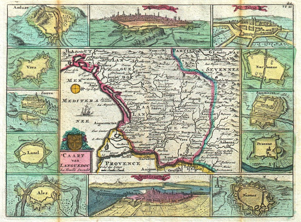
old maps of languedoc
daniel de la feuille
lawrence h. slaughter collection of english maps, charts, globes, books and atlases
covens en mortier
maps of archaeological sites in italy
storia degli antichi popoli italiani
map of ghent by jan blaeu
atlas van loon
maps from the earth and its inhabitants, vol. x
1890 in cairo
maps by willem and johannes blaeu
old maps of zierikzee
old maps of the stations of the exodus
joan blaeu
1912 maps of the ottoman empire
1910s maps of the balkans
flandria illustrata
old maps of lille
historical images of somalia
fra mauro map details
gemeente atlas van nederland - north holland
old maps of edam
gemeente atlas van nederland - north holland
old maps of alkmaar
prints by jan luyken in the rijksmuseum amsterdam
maps in the rijksmuseum amsterdam
4401 - 4500 of 26,489
Next page
/ 265