Log in
All resources
Create a design
338 Free Artworks of Maps Of The United States
maps in the library of congress
map postcards
oil on canvas
curt teich postcard archives
maps in portrait paintings
maps of the united states in art
portrait
new amsterdam
old maps of the united states
maps of nieuw nederland
claes jansz. visscher (i)
joannes van doetecum (i)
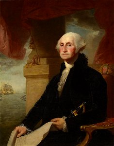
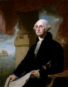
george washington (constable-hamilton portrait)
neoclassicism
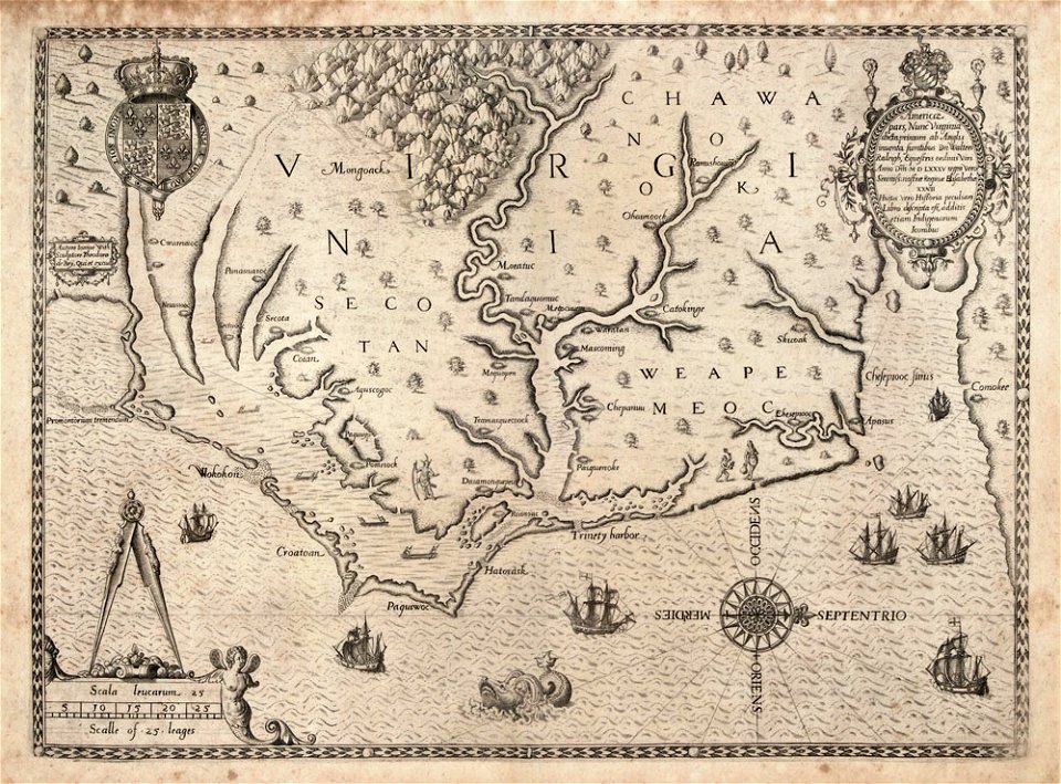
the generall historie of virginia (john smith)
17th-century maps of bermuda
1660 in new york city
fort amsterdam
portrait paintings in the kimbell art museum
portrait paintings by louis-léopold boilly
james monroe in art
clyde osmer deland
west-indische compagnie
image restoration
1805 maps of the united states
maps by john cary
pemberton square
scollay square
maps by willem and johannes blaeu
hudson valley
old constellation maps
maps by samuel dunn
cornell: persuasive cartography: the pj mode collection
gerrymandering in the united states
curt teich postcard archives
map postcards
paintings by ezra ames
simeon de witt
old maps of the united states
old maps of virginia
1892 in the united states
laredo, texas
lansdowne portrait of george washington
neoclassicism
jacques le moyne de morgues
1591
maps of the west-indische compagnie
1800 maps of the united states
cadastral maps of the united states
maps of mount vernon
media contributed by the frick collection
naïve art
operation passage to freedom
anti-communist propaganda
1895 maps of new york (state)
old maps of albany, new york
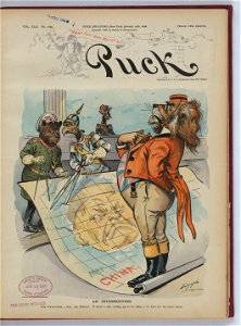
1898 covers of puck magazine
drawings of scissors
maps of the history of the united kingdom
maps of voyages
maps of saguaro national park
oro valley
maps in the library of congress
adriaen van der donck
st andrew's church (roman catholic, manhattan)
sanborn maps of manhattan published in 1905
16th-century maps of north carolina
theodor de bry
cecil calvert, 2nd baron baltimore
works by gerard soest
maps in the library of congress
fortifications of port hudson
maps in the library of congress
1877 in ohio
glaciers and glaciation (1910)
maps of yakutat bay
1630s maps of new york city
manatus map
1898 covers of puck magazine
drawings of scissors
curt teich postcard archives, curt teich & company
map postcards
old maps of the united states
copper engravings
bird's eye view of knoxville, tennessee, 1886
maps in the library of congress
collections of the museum of the american revolution
david martin (artist)
1890s maps of the united states
maps of the thousand islands
maps in the library of congress
1849 maps of philadelphia
curt teich postcard archives
postcards of texas
old maps of the united states
copper engravings
charles frederick cheffins
1841 maps of texas
1841 maps of the united states
maps by george w. boynton
curt teich postcard archives
postcard collecting
statue of josé gervasio artigas (washington, d.c.)
maps of washington, d.c.
old maps of the united states
sanson maps of north america
curt teich postcard archives
map postcards
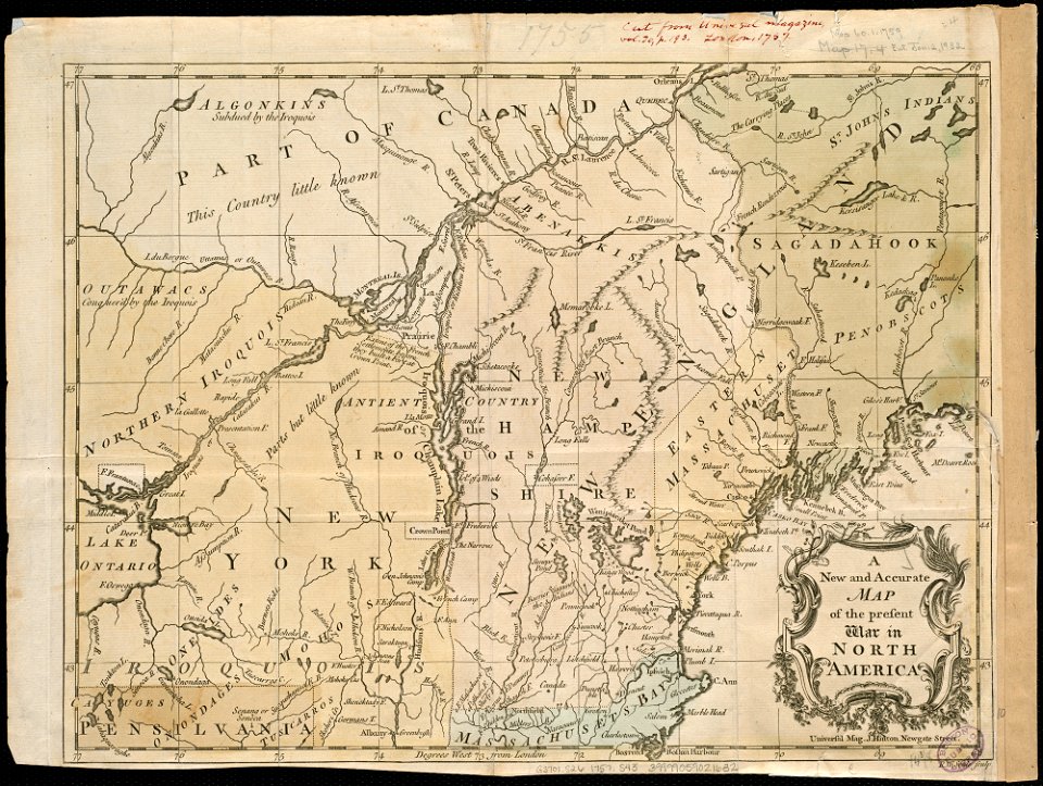
1777 maps of new york (state)
1777 maps of new jersey
curt teich postcard archives, curt teich & company
map postcards
1747 maps of north carolina
maps by emanuel bowen
2008 u.s. presidential election maps, democratic primary
2008 iowa election maps
lawrence h. slaughter collection of english maps, charts, globes, books and atlases
nypl lionel pincus and princess firyal map division
portrait paintings of men in the rijksmuseum amsterdam
american paintings in the rijksmuseum amsterdam
charts and maps of the royal museums greenwich
1778 maps of new york (state)
everett d. graff collection of western americana
cherokee nation
maps in the library of congress
1898 maps of spain
maps by gouverneur k. warren
maps by edwin freyhold
chicago and the midwest, newberry library
illinois & michigan canal
1849 maps of north america
old maps of canada
glaciers and glaciation (1910)
hubbard glacier
curt teich postcard archives
postcards of muncie, indiana
1830 maps of pennsylvania
battle of brandywine
maps by willem and johannes blaeu
new amsterdam
maps by peter lesley
maps by james hall
old maps of the united states from the norman b. leventhal map center
old maps of canada from the norman b. leventhal map center
eran laor cartographic collection
daniel friedrich sotzmann
19th-century solar eclipse maps
solar eclipse of 1900 may 28
pierre antoine tardieu
maps from gallica
new york state supreme court 60 centre street
bromley maps of manhattan published 1955–56
curt teich postcard archives
map postcards
everett d. graff collection of western americana
stephen f. austin
bromley maps of manhattan published 1955–56
court square building
curt teich postcard archives
postcard collecting
1850s maps of the americas
maps by john tallis
old maps of georgia (u.s. state)
maps in the library of congress
1895 maps of new york (state)
old maps of albany, new york
maps in the library of congress
1861 maps of the united states
1810 maps of north america
1810 maps of mexico
portrait paintings in the art institute of chicago
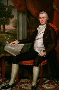
paintings by ralph earl
curt teich postcard archives
map postcards
maps in the library of congress
1877 maps of the united states
old maps of st. augustine, florida
john white (colonist and artist)
maps in the library of congress
1861 maps of the united states
glaciers and glaciation (1910)
maps of glacier bay
new york state supreme court 60 centre street
columbus park (manhattan)
1806 maps of the united states
maps by john cary
old maps of montana
julius bien
ross township, butler county, ohio
hill forts in the united states
charts and maps of the royal museums greenwich
1777 maps of new york (state)
bird's eye view maps of vermont
history of bennington, vermont
potsdam conference on stamps
stamps of russia, 1995
maps in the library of congress
1773 maps of the united states
albert levering
puck, 1910
chicago and the midwest, newberry library
maps by rand mcnally
old maps of georgia (u.s. state)
maps in the library of congress
maps of battles
1862 maps
hudson river in the 19th century
steamboats of the united states
the loyal west in the times of the rebellion
1803 maps of the united states
1 - 100 of 338
Next page
/ 4